Yosemite National Park – Veteran’s Day, National Free Forest Service, and National Park day always prompt me to think of Yosemite National Park. Yosemite continues to capture my spirit and call me to try new trails, view new heights and challenge my will to complete the climb. On Veterans Day, I skipped the parades. Instead, I decided to enjoy the very freedoms given to me by so many brave individuals. My 16-year-old son (Cade) chose the day hike for us today. Sunrise Lakes is the halfway point for many to Clouds Rest. I had spoken to several hikers this summer while exploring Cathedral Lakes that the Sunrise Camp and Lakes loop was one that I should commit to doing. So when Cade suggested we take the West Trail off Tenaya Lake and climb to the Sunrise Lakes, I knew it would be a great day. The reviews on this Trail focus, if not feature, a gnarly set of switchbacks about halfway along this Trail. Rightfully so, as I will explain a little later.
But this Trail has a lot to offer someone looking for a great Yosemite day trip adventure. Starting at the parking area on the West edge of Tenaya Lake, you will need to pay attention to where the trailhead is; easy to mistakenly take the west Trail, which heads to the May Lake area. The Trail to Sunrise Lakes and Sunrise Camp is on the East edge of the parking area. It follows a rather ragged path that may be under some construction towards Tenaya Lake. Being November, we didn’t have to worry about crossing any water in the meadow. Still, in early summer, you may need to do a little rock hopping or wading across a stream.
The Trail follows the stream for a bit, and I assume that in the spring and early summer, this is a delightful area to hike as the water flows. Just after turning from the creek, you will walk upon a Boulder area to the right, begging you to climb up and look. Highly suggested as you get a great view of the Tenaya Canyon, a peak at a little unnamed body of water at the base of one of the cliffs. Once you pass this area, you will start downhill for just a bit as you head for the base of what one hiker yesterday referred to as “The WALL.”
The “Wall”
A vertical climb of approximately 1 mile over a gnarly set of switchbacks with over 1000′ ft in elevation gain. “The Wall” is a challenging section of Trail that thousands do each year heading to Clouds rest. For beginners, however, You will be glad you wore your hiking boots, brought your water and gave yourself time to complete it. This part of the path is like climbing a staircase in a skyscraper. Your legs will burn.
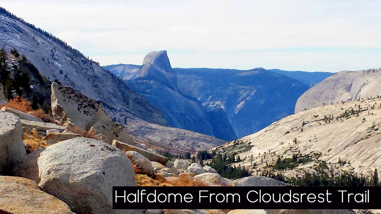
On your ascent up “The Wall,” we did find a hidden treasure. About 1/3 of the way up the climb, we came to rest on a corner of one of the west switchbacks. In your view, there is a huge Ponderosa Pine all by itself to the west of the Trail. Looking back across the canyon, you can see that you are just about at the height of Olmsted Point and that it is directly across the canyon. If you venture toward that tree across the face of the mountain, you will capture a glimpse and a great picture spot of Half Dome. This location is only about 50 yards off the path, but you will need to be careful of your footing, and the slope could cause a little trouble. If your heading to Clouds rest, then no need to stop here, but is Sunrise Lakes is your destination. Not only is it a good break spot, but it is also a fantastic view. The switchbacks in November are a bit tricky as ice from the first snow has settled in on several areas of the Trail, so footing and the right gear are essential. My only recommendation is to pace, take your time, watch your step, take lots of breaks and drink your water. It is a long climb, but you can do it, and it is worth it. Once you complete” The Wall you reach a junction on top of the mountain; take a moment and catch your breath and get your barring.
Sunrise Lakes
Sunrise Lakes is to the Left. Straight ahead will lead you to the Trail for Clouds Rest. The Signs don’t say Sunrise Lakes. They instead point you to Sunrise Camp, which is another 2.5 miles. Sunrise Lakes are only about a half mile from the junction.
The Trail will wind you right next to the first and third lakes. The small climb from the First to the third as you go up along the ridge. The second Lake is off to the left; you need to watch for it as if you are focused on going up the hill, you will miss it. It is about 100 yards off the path through a small set of trees. The Sunrise lakes are smaller than the Cathedral lakes in comparison. The mountain peaks are probably less spectacular than other hikes. However, still, the granite domes reflect in this high mountain lake water just the same and they are so peaceful. Short trips around the lakes give you some great photo ops. On the First and Second Lake we walked over to the ridge overlooking the Tenaya Canyon which we just hiked through for a great panoramic view across the North Face of the Canyon, which includes Tuolumne Peak and MT Hoffman. Another great feature of this hike is the Granite Tallas piles at the base of each Lake. So fascinating to see the large chunks of broken rock that have been shaven off the face by weather and ice.

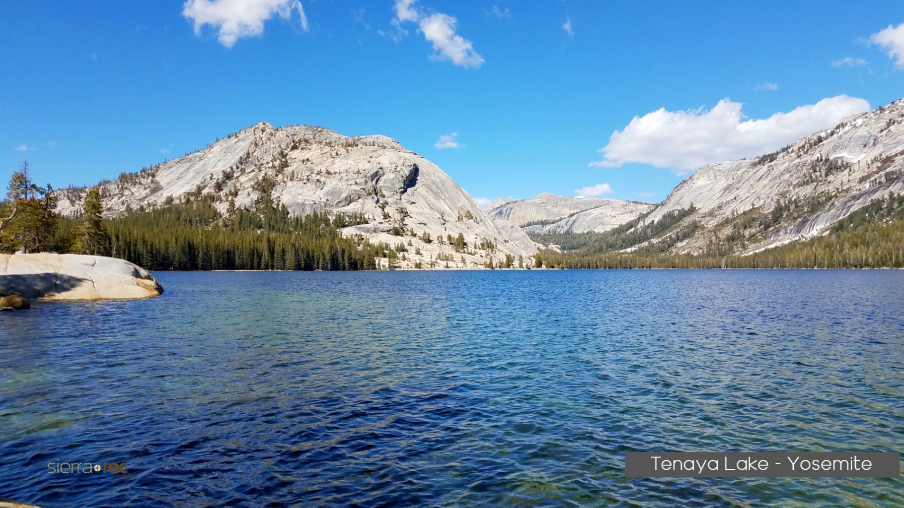
Once you have your fill of the lakes and start to head back on your day trip, the thoughts of going down are much more pleasant than going up the wall. Watch your steps coming down, as this is where the twisted ankle comes into play. Our trip was about 2.5 hours up and 1.5 hours down, which might help you gauge your time. I plan on 4-6 hours for this trip. Once you get back to the Tenaya Lake area, take time to go over to Tenaya Lake shores for a few great photo ops from the west edge, this is an excellent area for soaking feet and lounging on the granite by the Lake. In the summer season, I always make it to this side of the Lake for an afternoon swim after a long day on the Trail.

Sierra REC enjoys sharing our day trip adventures and hope is helps you be inspired to try a new adventure or to explore an old favorite. The tips and suggestions we present ours from our personal perspective. We always suggest you stay on the trails unless you are comfortable with direction and safety concerns that can arise by going off trail in areas. Please stay safe and enjoy your next adventure to the Sierra. We do hope you will share your photos and stories with us at sierrarecinfo@gmail..com or on our Facebook and Pinterest pages


Comments 2