Discover More Outdoor in the Lakes Basin – Plumas National Forest
Located nine miles southwest of Graeagle, California, the Lakes Basin recreation area well known for its rugged beauty and special geological features. There is breathtaking scenery and over 20 small lakes nearby, most of which are accessible by hiking trails and a considerable number of them right next to the road.. This area provides a multitude of recreational activities including camping, fishing, boating, hunting, mountain biking, horseback riding, picnicking, hiking, backpacking, swimming, windsurfing and nature study. In the winter visitors can snowmobile, cross-country ski and snowshoe.
Over thirty miles of hiking, trails meander next to crystal clear glacially carved lakes. Most trails in the Basin are approved for Hikers, Bikers and Horseback trail riders.
Recreational Trails in the Lakes Basin
- Bear Lakes Loop Trail
- Frazier Falls Trail – No Bikes or Horseback on the Frazier Falls Trail
- Gray Eagle Creek Trail
- Jamison Creek Trail
- Long Lake Trail
- Mt. Elwell Trail and Loop
- Round Lake Trail and Loop
- Silver Lake and Mud Lake Trails
- Smith Lake Trail
Bear Lakes Loop Trail
Discover the Beauty of Bear Lakes Loop Trail
The Bear Lakes Loop Trail, spanning two miles, stands as one of the most cherished hiking routes within the Lakes Basin Recreation Area. This trail promises a delightful journey with captivating vistas of four glacially carved alpine lakes, weaving through a diverse conifer forest, all set against the backdrop of towering peaks. Let’s embark on this remarkable trail adventure, starting from the trailhead on the south end of the parking lot.
Trail Highlights:
- Trailhead: Your Bear Lakes Loop adventure begins at the south end of the parking lot, where the trailhead eagerly awaits your arrival.
- Initial Ascent: The first leg of the journey encompasses a gentle 0.6-mile climb through a mixed conifer forest, leading you to the serene Big Bear Lake. This section of the trail is known for its vibrant wildflowers, offering a colorful display of nature’s beauty. Approximately 0.1 mile before reaching the lake, veer right at the intersection with the Round Lake Connector Trail.
- Exploring the Lakes: Continue your hike, covering 0.8 miles as you pass by Big Bear, Little Bear, and Cub Lakes, before connecting with the Silver Lake Trail. Most of this stretch maintains a gradual uphill grade, and the lakes provide opportunities for exploration and relaxation. Beyond Cub Lake, the trail inclines slightly. At the intersection with the Silver Lake Trail, bear right and continue for 0.3 miles to reach the Long Lake Connector trail. For those interested in visiting Long Lake, refer to the Notes section for additional guidance.
- Return to the Parking Area: From the Long Lake Connector, embark on a 0.3-mile descent, which will lead you back to the parking area. Be mindful that this is the steepest part of the loop, so take your time and prioritize safety.
Additional Information:
- Intersecting Trails: The Lakes Basin Recreation Area boasts numerous intersecting trails, offering you the chance to explore and create unique hiking adventures.
- Long Lake Viewpoint: A wonderful view of Long Lake awaits just 0.2 miles south on the Silver Lake Trail.
Plan Your Lakes Basin Adventure:
Whether you’re drawn to the allure of alpine lakes, the charm of wildflowers, or the mesmerizing beauty of the surrounding peaks, the Bear Lakes Loop Trail promises an unforgettable hiking experience.
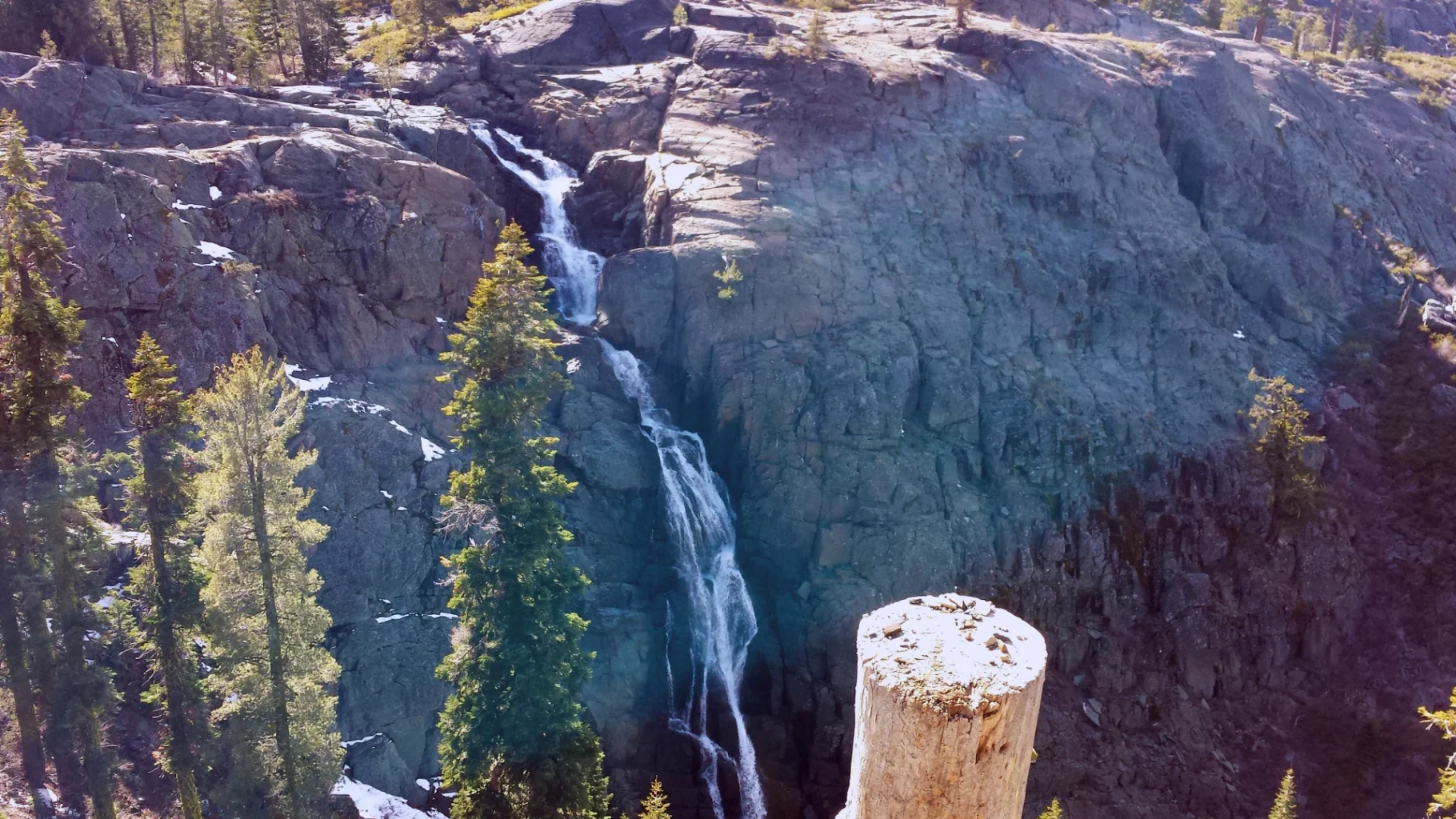
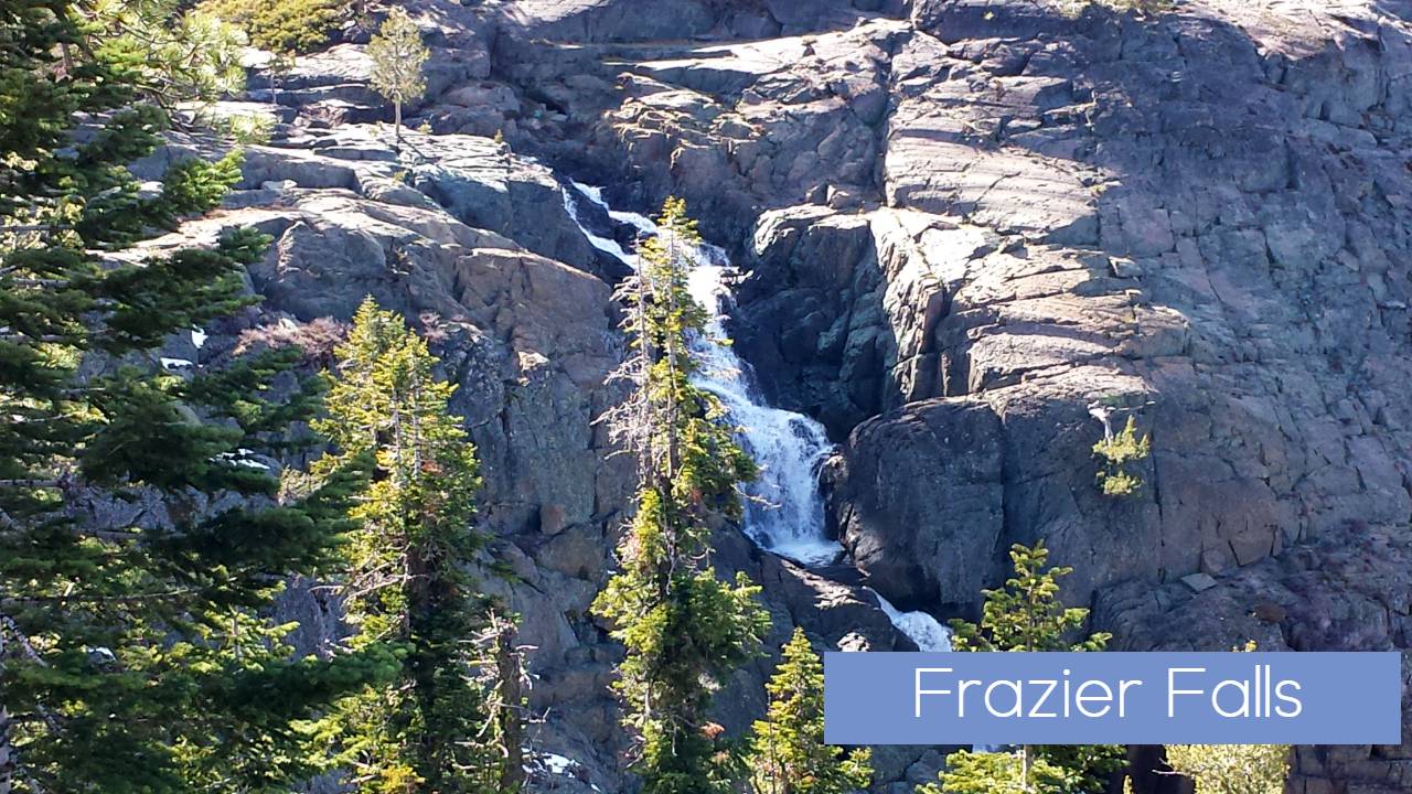
Frazier Falls Trail
An extraordinary adventure waiting to unfold just a short drive from Graeagle, California at Frazier Falls. This beautifully paved accessible trail spans half a mile, guiding you through the enchanting landscape of glacially carved granite terraces. Your journey culminates at a breathtaking vantage point that overlooks the awe-inspiring Frazier Falls, a natural wonder that announces itself with a thunderous roar.
Trail Highlights:
- Spectacular Waterfall: As you approach the viewpoint, you’ll be captivated by the sight of Frazier Falls, a stunning cascade of white water that plummets 178 feet into the canyon below. When the sun graces the falls just right, vibrant rainbows dance within the mist, creating a scene straight out of a dream.
- Accessible Adventure: This trail is thoughtfully designed for accessibility, ensuring that visitors of all abilities can enjoy the natural beauty of the area. The paved path meanders gently away from the forested trailhead, with a manageable grade of less than 14%. Along the way, informative displays offer insights into the region’s history and natural wonders.
- Tranquil Stopovers: For moments of reflection or simply to catch your breath, wooden benches dot the trail, providing peaceful spots to pause and take in the surroundings. Approximately halfway through the trail, a sturdy wooden bridge spans Frazier Creek, which carries the outflow from Gold Lake. This area, just upstream from the falls, demands caution due to its swiftly moving waters.
- Trailhead Picnic Area: After your exhilarating journey, make the most of the trailhead picnic area, a perfect place to unwind. Five picnic tables, trash containers, and restroom facilities are conveniently available for your comfort.
Trail Safety and Tips:
- Frazier Falls Height: Frazier Falls boasts an impressive height of 178 feet, making it a sight to behold.
- Accessibility: Please note that Frazier Falls Trail is open exclusively to foot traffic and wheeled accessible traffic, including motorized scooters.
- Pet-Friendly: If you’re bringing your furry companion, ensure they are under control at all times to maintain the safety and serenity of the trail.
- Parking Etiquette: Be considerate when parking and refrain from crushing vegetation or obstructing traffic.
- Stay Vigilant: The swift waters of Frazier Creek, especially near the top of the falls, can be deceptively strong. Exercise caution, especially with children and pets.
- Safety Barriers: For your safety, do not venture beyond the designated barriers at the overlook.
- Water Treatment: Avoid drinking from natural water sources without proper treatment. Be sure to bring sufficient water to stay hydrated during your visit.
- Weather Preparedness: Be ready for changing weather conditions by dressing in layers. It’s advisable to check the weather forecast before embarking on your hike.
- Trail Maintenance: The Frazier Falls Trail is lovingly maintained with the support of the Lions Club, ensuring a pristine and enjoyable experience for all.
Directions: To embark on your Frazier Falls adventure, drive south from Graeagle on Highway 89 for approximately 1.5 miles. Take a right onto Gold Lake Highway and continue for another 1.5 miles. Then, make a left turn onto Frazier Falls Road and journey 4 miles along this narrow paved road to reach the trailhead parking area.
Prepare for an unforgettable excursion into the heart of nature’s splendor at Frazier Falls Trail.
Explore the Rich Diversity of Gray Eagle Creek Trail
Embark on a captivating journey through the bountiful riparian zone, where wildflowers bloom abundantly, and wildlife thrives. Gray Eagle Creek Trailhead, situated at the northeast end of the parking area, serves as your gateway to this enchanting hiking experience.
Trail Highlights:
- Riparian Beauty: Gray Eagle Creek Trail is a natural wonderland, boasting a vibrant riparian zone that enchants hikers with its lush wildflowers and diverse wildlife. This unique ecosystem is a narrow transitional strip of land between upland habitats and bodies of water, in this case, the scenic Gray Eagle and Smith Creeks. The overhanging vegetation helps maintain cool water temperatures, providing a habitat for aquatic creatures, including the endangered Sierra Nevada Yellow Legged Frog.
- Connector Options: Your adventure begins with a gradual descent from the trailhead, covering a distance of 2.1 miles. At the 2-mile mark, you’ll encounter the Smith-Gray Eagle Connector, offering access to the Gray Eagle Creek/Smith Creek Loop. Continue along Gray Eagle Creek Trail for an additional 0.1 mile to reach a pivotal fork in the path.
- Exploration Choices: At the fork, you have two enticing options. The trail to the left extends 2.3 miles, primarily along a road over private property, leading you to the charming town of Graeagle. Conversely, the 0.5-mile trail to the right guides you across a creek bridge, concluding your journey at Gold Lake Highway.
- Loop Adventure: For those seeking a loop adventure, a gradual ascent of 1 mile over the ridgeline brings you to Smith Creek Trail. Turn left and continue for 0.7 miles, where you’ll connect to Smith Lake Trail. Take a left here, and you’ll ascend through the forest before descending along the hillside, ultimately leading you back to the parking area.
Discover the Riparian Zone: The Gray Eagle Creek Trail’s most compelling feature is undoubtedly the riparian zone it traverses. These zones are incredibly productive and biologically diverse ecosystems, serving as the crucial transition between upland habitats and bodies of water. Gray Eagle and Smith Creeks are the prominent water bodies here, and the overhanging vegetation plays a vital role in maintaining cool water conditions, making it an ideal habitat for aquatic creatures, including the endangered Sierra Nevada Yellow Legged Frog.
As you explore, you’ll encounter several fens—wetlands characterized by flora adapted to water and peat soils. These soils are rich in dissolved minerals but low in plant nutrients, adding yet another layer of biodiversity to this already fascinating environment.
Trail Logistics:
- Accessibility: Gray Eagle Creek Trail and its loop are open to foot traffic, mountain biking, and horseback riding, ensuring accessibility to a wide range of outdoor enthusiasts.
- Parking Etiquette: Please be considerate when parking, avoiding damage to vegetation and obstructing traffic. Remember to pack out all trash to preserve the pristine surroundings.
- Restroom Facilities: A restroom is available at the parking area for your convenience.
- Hydration and Safety: Refrain from drinking from naturally occurring water sources without proper water treatment. Keep your dogs under control throughout your hike, and be mindful of changing weather conditions by dressing in layers.
Directions: To embark on your Gray Eagle Creek Trail adventure, travel south from Graeagle on Highway 89 for approximately 1.5 miles. Take a right onto Gold Lake Highway, continue for 4 miles, and then turn right at Gray Eagle Lodge. Just before reaching the lodge, follow the signs toward Smith Lake Trail, and you’ll find Gray Eagle Creek Trailhead at the northeast end of the parking area.
Prepare to immerse yourself in the wonders of the riparian world as you explore Gray Eagle Creek Trail.
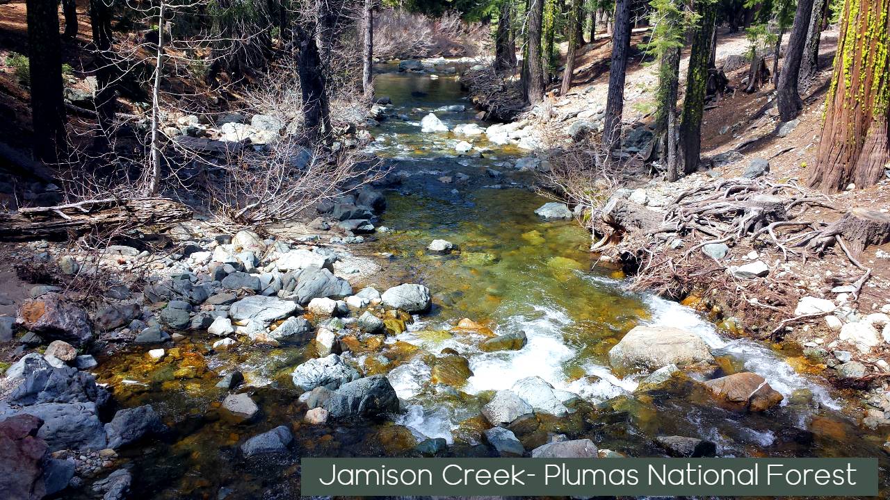
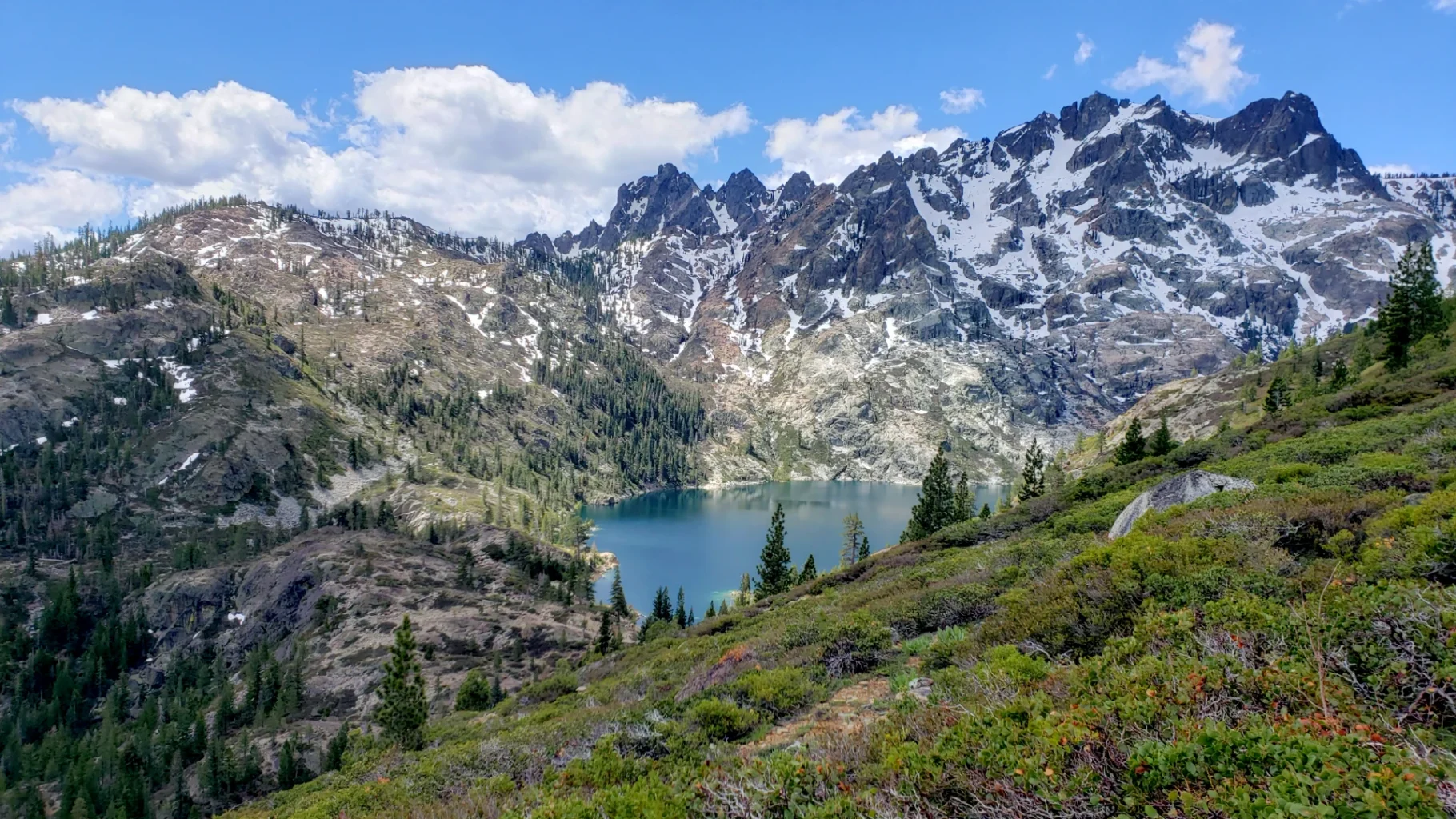
Embark on a Scenic Journey Along the Jamison Creek Trail
Prepare to be captivated by the stunning 3.7-mile in-and-back Jamison Creek Trail, an adventure that leads you from the heart of Plumas Eureka State Park to the iconic Pacific Crest Trail. Along this enchanting path, you’ll encounter pristine alpine lakes, majestic Red Fir forests, refreshing water crossings, vibrant summer wildflowers, and the golden hues of autumn aspens—a journey that promises to leave an indelible mark on your memory.
Trail Highlights:
- Picturesque Alpine Lakes: Your trek begins within the picturesque confines of Plumas Eureka State Park, near the historic remnants of Jamison Mine. The trail closely follows the course of Little Jamison Creek, guiding you past a series of captivating alpine lakes that glisten like jewels in the rugged terrain.
- The Stairway to Heaven: In the initial half-mile of your adventure, you’ll encounter a section known as ‘The Stairway to Heaven,’ characterized by imposing rock steps. This challenging ascent is a testament to the trail’s grandeur, rewarding your efforts with breathtaking views.
- Intersection with Smith Lake Trail: Approximately one mile into your journey, you’ll reach an intersection with the Smith Lake Trail. This trail originates near Gray Eagle Lodge in the Lakes Basin Recreation Area, offering an alternative route for exploration.
- Lakes Basin Transition: Around the one-mile mark, the Jamison Creek Trail leaves the state park and enters the Lakes Basin Recreation Area. Here, a short trail to the right leads you to the enchanting Little Jamison Falls, a hidden gem waiting to be discovered.
- Wildflower Haven: As you continue your hike, you’ll skirt Grass Lake, a wildflower haven throughout the summer months. The vibrant blooms against the backdrop of the Sierra Nevada Mountains create a picture-perfect scene.
- Trail Intersections: Your journey leads to a series of trail intersections, including the Jamison Lake Trail, a 0.8-mile route leading to the 0.2-mile Rock Lake Trail, which in turn connects to a trail leading to Wades Lake. This intricate trail network offers multiple exploration options, all with their unique charms and water crossings.
- Mt. Washington and the Pacific Crest Trail: Just 0.4 miles away from your current location lies the intersection with the Mt. Washington Trail. And, a mere 0.2 miles further, you’ll reach the legendary Pacific Crest Trail—a must-visit spot for avid hikers and outdoor enthusiasts.
Trail Logistics:
- Accessibility: The Jamison Creek Trail is open to foot, biking, and equestrian traffic. Please note that wheeled vehicles, including bikes, are not allowed on the Pacific Crest Trail.
- Camping Opportunities: Backpackers are welcome to camp along this trail, creating the perfect opportunity for a serene backcountry experience. However, it’s essential to pack out all trash and adhere to backcountry safety tips, including water treatment, sanitation, and bear awareness.
- Pet-Friendly: If you’re bringing your four-legged companion, ensure they are under control at all times to maintain the serenity of the trail.
Directions: To embark on your Jamison Creek Trail adventure, begin by heading south from Graeagle on Highway 89 for approximately 1.5 miles. Make a right turn onto Gold Lake Highway, and continue for 4 miles. Just before reaching Gray Eagle Lodge, follow the signs toward Smith Lake Trail, where you’ll discover the Jamison Creek Trailhead, ready to usher you into the heart of the Plumas National Forest.
Prepare to be mesmerized by the diverse natural beauty that surrounds you as you explore the Jamison Creek Trail. Whether you’re hiking, biking, or riding on horseback, this trail offers a gateway to the Sierra Nevada’s pristine wilderness, where every step reveals a new facet of the natural world.
Discover the Beauty of Long Lake Trail
Prepare to immerse yourself in the captivating Long Lake Trail, a six-mile out-and-back hike that begins near Gray Eagle Lodge in the Plumas National Forest’s Beckwourth Ranger District. This scenic adventure takes you on a journey filled with natural wonders, including cascading waterfalls, vibrant summer and fall wildflowers, encounters with local wildlife, access to serene lakes, and breathtaking vistas that will leave you spellbound.
Trail Highlights:
- Long Lake Dam: Your hike commences at the southwest end of the parking area, where you’ll quickly find yourself skirting around Gray Eagle Lodge. Within the first 2.2 miles, you’ll reach the picturesque Long Lake Dam, a tranquil spot offering a taste of the beauty that Lakes Basin has to offer.
- Natural Wonders: As you progress along the trail, you’ll have the opportunity to explore a multitude of natural attractions. This includes access to mesmerizing waterfalls, a symphony of summer and fall wildflowers, and sightings of local wildlife that call this wilderness home.
- Lake Vistas: The trail provides access to several pristine lakes and offers stunning vistas that showcase the serene beauty of the Lakes Basin Recreation Area.
- Long Lake Connector Trail: As you approach the eastern side of the dam, you’ll encounter the 0.8-mile Long Lake Connector Trail, which leads to the popular Bear Lakes Loop—a delightful side adventure for those seeking more.
- Mt. Elwell Trail and Mud Lake Trail: Continuing on the west side of Long Lake, the trail skirts the lake’s edge before ascending to an intersection with the Mt. Elwell Trail and Mud Lake Trail. These trails offer additional exploration opportunities and panoramic views of the surrounding landscape.
- Lakeside Retreat: On your return journey, take some time to relish the cool waters of Long Lake. It’s the perfect spot to enjoy a relaxing lakeside lunch and soak in the serene atmosphere.
Trail Logistics:
- Access and Terrain: Long Lake Trail follows an out-and-back route, making it accessible for hikers of various skill levels. The terrain features a mix of natural surfaces and well-maintained pathways.
Directions: To embark on your Long Lake Trail adventure, start by heading south from Graeagle on Highway 89 for approximately 1.5 miles. Make a right turn onto Gold Lake Highway and continue for 4 miles. Just before reaching Gray Eagle Lodge, follow the signs toward Smith Lake Trail. The trailhead for Long Lake Trail is located at the southwest end of the parking area.
Explore the Majestic Beauty of Mt. Elwell Trail
Prepare for an unforgettable journey through stunning panoramas, dense forests, rugged outcrops, wildflower-dotted meadows, and breathtaking fall foliage as you embark on the Mt. Elwell Trail. This epic 12-mile out-and-back hike, leading to the renowned Pacific Crest Trail, offers a profound connection with nature. Alternatively, the Mt. Elwell Loop presents an 8-mile alternate route that winds its way back via the Long Lake Trail.
Trail Highlights:
- Starting Point: Your adventure begins at the Smith Lake Trailhead, located at the northern end of the parking area. Within the first mile, take a left at the intersection with the Smith Creek Trail. A short distance further, bear left onto the Mt. Elwell Trail, setting the stage for your ascent into a captivating fir and Sugar Pine forest.
- Maiden Lake: Around the halfway point of the three-mile ascent, you’ll encounter the picturesque Maiden Lake, a tranquil gem amidst the wilderness. From this point onward, the trail’s challenge level gradually intensifies, with several craggy outcrops marking the crest of Mt. Elwell. Caution is advised when navigating these rocks due to steep drop-offs and strong winds.
- Panoramic Viewpoints: The rewards of your climb include stunning panoramic viewpoints that reveal the grandeur of the surrounding landscape. Gaze upon prominent landmarks such as Mt. Shasta, Mt. Lassen, the Feather River Valley to the north, Sierra Buttes, Bear Lakes, Silver Lake, and Round Lake to the south, Smith Peak Lookout, Gold Lake, Beckwourth Peak, and Sierra Valley to the east, and Table Mountain and Mt. Fillmore to the west. Keep an eye out for remnants of an old fire lookout; these historical artifacts should be preserved and not disturbed.
- Descent and Options: Following your peak experience, the trail descends less than a mile to intersect with the Long Lake Trail. As you descend, you’ll have the opportunity to spot Jamison Lake, Rock Lake, and Wades Lake to the northwest. For those opting for the Mt. Elwell Loop, the Long Lake Trail serves as the return path. Mt. Elwell Trail, on the other hand, continues for 1.1 mile until it connects with the Pacific Crest Trail.
- Long Lake Trail: This segment skirts the north side of Long Lake, leading to the dam. Many hikers choose to cool off in the pristine waters of the lake. Below the dam, you’ll encounter wet areas teeming with wildflowers, providing a captivating sight from spring through fall. The trail ultimately leads back to the parking area, covering a distance of two miles.
Trail Logistics:
- Accessibility: The Mt. Elwell Trail is open to foot, bike, and equestrian traffic, making it accessible to a variety of outdoor enthusiasts.
Directions: To embark on your Mt. Elwell Trail adventure, start by heading south from Graeagle on Highway 89 for approximately 1.5 miles. Make a right turn onto Gold Lake Highway and continue for 4 miles. Just before reaching Gray Eagle Lodge/Smith Lake Trail, turn right to access the parking area and trailheads.
Additional Information:
- Restroom Facilities: A restroom is conveniently available at the parking area.
- Safety and Preparedness: Always be prepared for changing weather conditions by dressing in layers and staying hydrated. It’s advisable to carry a map and exercise caution during lightning events.
- Environmental Responsibility: Respect the environment by avoiding human waste within 100 feet of any trail, road, campsite, or water source. Properly bury solid human waste at a depth of 8 to 12 inches and pack out all tissue. Remember to pack out all trash to leave the wilderness pristine for future generations.
Discover the Beauty of Round Lake Trail
Round Lake Trail offers two enchanting hiking options to immerse yourself in the splendor of nature. You can embark on the 4.8-mile out-and-back Round Lake Trail or opt for the 4.0-mile Round Lake Loop, which returns to the trailhead, ensuring a satisfying adventure for all types of hikers.
Trail Highlights:
- Beginning of the Journey: Both hiking options commence with a serene 0.8-mile stroll through a fragrant pine forest. This leisurely walk guides you near snowmelt ponds and a tapestry of vibrant wildflowers. Following this tranquil introduction, you’ll encounter a 0.9-mile moderate-level uphill segment that leads you to the site of the Round Lake Mine. Here, interpretive signs share the fascinating history of the mine and the gold mining legacy in this region.
- Choosing Your Path: At this juncture, you have two trail options. The uphill trail leading to the south is Round Lake Trail—a challenging 0.75-mile ascent that ultimately connects with the Pacific Crest Trail. Opting for this route rewards you with sweeping panoramic views of several picturesque lakes and the surrounding majestic peaks.
- The Round Lake Loop: Alternatively, you can choose the downhill trail leading west, which is part of the Silver Lake – Round Lake Connector and an essential component of the Round Lake Loop. Starting from the old mine site, this trail extends an additional 2.3 miles, guiding you past six glacially carved alpine lakes, each offering its unique charm and serenity. The 0.9-mile connector section allows you to traverse the shores of Round and Silver Lakes before intersecting with the Silver Lake Trail.
- Breathtaking Views: As you progress along this loop, you’ll also venture onto the Bear Lakes Trail, which extends for 0.8 mile past Cub, Little Bear, and Big Bear Lakes. The captivating views along this section are complemented by a wonderful sight of Long Lake. Many hikers choose to take a refreshing break in the serene waters of Big Bear Lake.
- Completing the Loop: Just below Big Bear Lake, turn right onto the Round Lake Connector for the final 0.5-mile uphill stretch, which brings you back to the trailhead. This satisfying return journey allows you to relish the natural beauty of the surrounding landscape one last time.
Trail Logistics:
- Accessibility: Round Lake Trail and the Round Lake Loop are open to foot traffic, making them accessible for hikers eager to explore the wilderness.
Directions: To embark on your Round Lake Trail adventure, head south from Graeagle on Highway 89 for approximately 1.5 miles. Make a right turn onto Gold Lake Highway and continue for 8 miles. When you reach Gold Lake Lodge, you’ll find the trailhead at the northwest end of the parking area. The upper trail leading south is Round Lake Trail, while the lower trail is the Round Lake Connector, marking the endpoint of the Round Lake Loop.
Additional Information:
- Restroom Facilities: Restrooms are available at the parking area for your convenience.
- Safety and Preparedness: Be prepared for changing weather conditions by dressing in layers and staying hydrated. Ensure you carry a map and remain cautious during lightning events.
- Environmental Responsibility: Respect the environment by adhering to the Leave No Trace principles. Ensure you pack out all trash and properly dispose of waste.

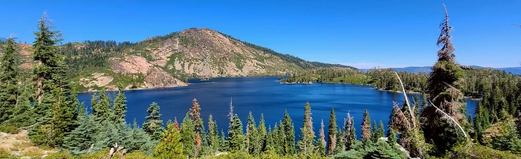
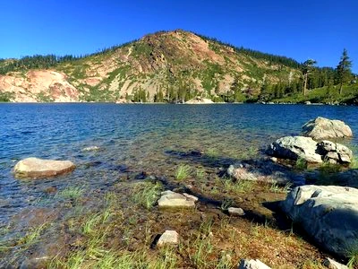
Silver Lake: A Serene Gem in Lakes Basin Recreation Area
Silver Lake, nestled within the Lakes Basin Recreation Area, stands as one of the true treasures of this picturesque region. Its tree-lined shores, adorned with countless picturesque coves, beckon photographers, nature enthusiasts, and seekers of solitude alike. If you crave adventure, follow the trail to uncover expanded horizons and even more natural wonders.
Hidden Trail Gems: Trails like Silver Lake Trail and Mud Lake Trail, while not possessing dedicated trailheads, are the unsung heroes that make Lakes Basin Recreation Area a beloved and diverse hiking destination. They connect to other trails, ensuring that there’s almost always another place to explore or an alternate path to take. By putting in a little extra planning and effort, you can transform out-and-back hikes into captivating loop adventures, each offering a unique experience when traversed in the opposite direction.
Trail Description: This description begins at the Bear Lakes Loop Trailhead, leading south from the parking area. After an easy 1.4-mile ascent, bear right at the Round Lake Connector and continue your journey past the three charming Bear Lakes. Following Cub Lake, the trail gradually ascends, eventually leading you to the Silver Lake Trail.
Turn left onto Silver Lake Trail. A mere 100 yards from this point, you’ll be treated to a breathtaking vista of Long Lake, with just another quarter-mile separating you from the shimmering Silver Lake itself. Here, you’ll encounter the Round Lake-Silver Lake Connector trail branching off to the left, but for now, stay on Silver Lake Trail as it begins a steeper ascent, spanning 2 miles and ultimately connecting with the Pacific Crest Trail.
Around 1.2 miles from Silver Lake, the Mud Lake Trail joins from the right, offering a beautiful 1.2-mile hike along granite terraces, accompanied by enchanting views of Mud Lake. This trail eventually leads to a junction with the Mt. Elwell Trail, adding to the hiking possibilities in this diverse area.
Getting There: To embark on your Silver Lake adventure, start by heading south from Graeagle on Highway 89 for approximately 1.5 miles. Take a right turn onto Gold Lake Highway and drive for 5 miles. When you reach Lakes Basin Campground, turn right and continue past the campground. At the end of the road, you’ll find the trailheads and parking area. Please note that trailers and large vehicles are not allowed.
Additional Information:
- Trail Connections: The beauty of these lesser-known trails lies in their connectivity to various other routes, allowing for endless hiking possibilities within the Lakes Basin Recreation Area.
- Exploring in Different Directions: Don’t hesitate to experience these trails in different directions, as each loop hike offers a distinct adventure.
Plan Your Lakes Basin Escape: Silver Lake and its surrounding trails offer a tranquil retreat in the heart of nature. Whether you’re an avid photographer, a seeker of solitude, or simply someone who loves the great outdoors, this area promises an enriching experience, with the promise of new discoveries around every bend in the trail.
Explore the Scenic Beauty of Smith Lake Trail
The Smith Lake Trail, located within the Lakes Basin Recreation Area, offers a captivating hiking experience that extends 2.5 miles, ultimately connecting with the Jamison Creek Trail in Plumas Eureka State Park. Along the way, hikers are treated to diverse opportunities, from visiting the serene Smith Lake to enjoying panoramic ridgeline vistas that overlook Smith Lake and the picturesque valleys of the Middle Fork of the Feather River.
Trail Highlights:
- Trailhead: The Smith Lake Trailhead is conveniently situated at the northwest corner of the parking area. This same trailhead provides access to Mt. Elwell and serves as the return leg of the Gray Eagle Creek / Smith Creek Loop.
- Initial Ascent: The trail embarks on a steady ascent, traversing the hillside and leading hikers to an initial climb. At the conclusion of this early ascent, the trail descends to reach Smith Creek. Here, at the intersection with Smith Creek Trail, turn left and cross the bridge over the creek. A little over a quarter of a mile from this point, you’ll arrive at the tranquil Smith Lake. Along the way, you’ll encounter the Mt. Elwell Trail intersecting from the left, and soon after, the trail splits. Both of these trails bear the name Smith Lake Trail. One of them grants access to Smith Lake itself, while the other continues onward to the Jamison Creek Trail.
- Smith Lake: Take some time to explore the scenic beauty of Smith Lake, and consider following the trail along its south shore for added adventure.
- Scenic Ridgeline Views: After your visit to Smith Lake, continue your journey toward Plumas Eureka State Park. The initial part of this section guides you along a ridgeline, offering breathtaking views of Smith Lake, the surrounding peaks, and the valleys below. Keep an eye out for hunting eagles and Osprey soaring over the lake. As you proceed, you’ll encounter the highest point of the trail before descending through alpine meadows and thick forest, eventually arriving at the Jamison Creek Trail. As the trail enters the State Park, it becomes slightly rocky and steep.
Getting There: To begin your Smith Lake Trail adventure, travel south from Graeagle on Highway 89 for approximately 1.5 miles. Then, make a right turn onto Gold Lake Highway and continue for 4 miles. When you reach Gray Eagle Lodge, turn right just before the lodge, following the signs toward Smith Lake Trail. The Smith Lake Trailhead can be found at the northwest end of the parking area.
Additional Information:
- Backpacking Opportunities: Backpacking is allowed at Smith Lake and in areas accessible via the Jamison Creek Trail, offering the chance for extended outdoor exploration and camping.
Embark on Your Smith Lake Adventure: Smith Lake Trail invites you to immerse yourself in the serene beauty of the Lakes Basin Recreation Area and Plumas Eureka State Park. Whether you’re drawn to the calm waters of Smith Lake, the sweeping vistas from the ridgeline, or the diverse natural landscapes, this trail promises an enriching outdoor experience. Pack your hiking boots and camera and set out to discover the wonders that await along this captivating trail.
Embark on a Sierra Buttes Hiking Adventure
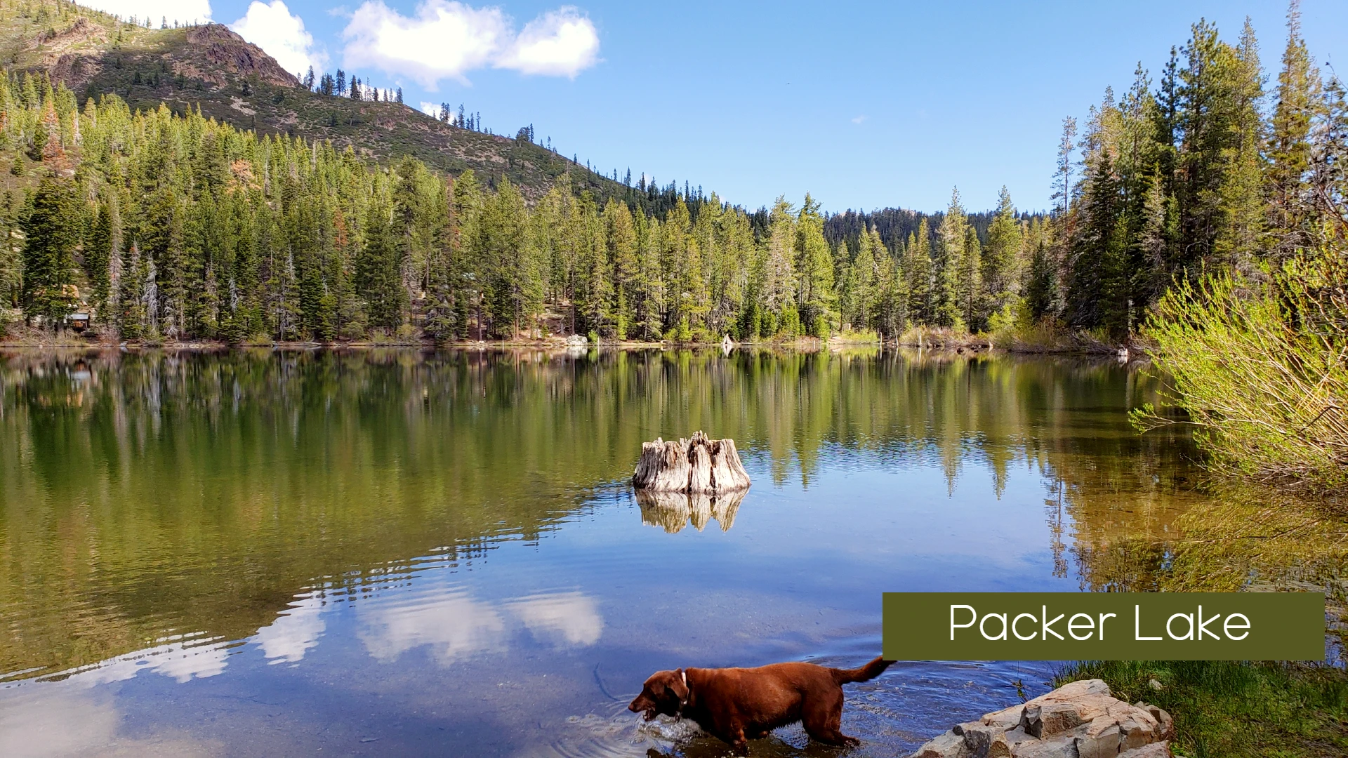
The Sierra Buttes hiking trail offers an exciting and picturesque journey through the heart of the Sierra Nevada mountain range. This iconic trail is renowned for its stunning vistas, alpine lakes, and the opportunity to conquer Sierra Buttes, a prominent peak that provides breathtaking panoramic views. Let’s explore this remarkable trail, starting from the trailhead near Packer Lake.
Trail Highlights:
- Trailhead: Begin your Sierra Buttes hiking adventure from the trailhead near Packer Lake, where the trail beckons you to explore its natural wonders.
- Initial Climb: The trail commences with a steady ascent as it winds its way through a forested landscape. As you ascend, take in the tranquil surroundings and the scent of pine in the air.
- Packer Saddle: After a challenging but rewarding climb, you’ll reach Packer Saddle. This is a great spot to catch your breath, soak in the views, and recharge before continuing your journey.
- Summiting Sierra Buttes: The highlight of this trail is the opportunity to summit Sierra Buttes. The final stretch to the summit involves a steep ascent, but the effort is well worth it. Once at the top, you’ll be treated to unparalleled vistas that stretch as far as the eye can see. Take time to savor the beauty and snap some memorable photos.
- Upper and Lower Lakes: On your descent, you’ll encounter Upper and Lower Lakes, offering cool, pristine waters perfect for a refreshing break. These alpine lakes are excellent spots for a picnic or simply to enjoy the serenity of the high mountain environment.
- Return to the Trailhead: After a memorable hike and exploration of Sierra Buttes, you’ll make your way back to the trailhead near Packer Lake. The descent provides a different perspective of the landscape and a chance to appreciate the surrounding wilderness.
Additional Information:
- Trail Variations: Depending on your preferences and time, you can choose to explore additional trails or loop options in the area, creating a personalized hiking adventure.
- Wildlife Encounters: Keep an eye out for wildlife such as marmots, deer, and a variety of bird species as you traverse this pristine mountain terrain.
Plan Your Sierra Buttes Expedition:
The Sierra Buttes hiking trail promises an immersive experience in the heart of the Sierra Nevada, combining challenging terrain with breathtaking scenery. Whether you’re an avid hiker or simply seeking a memorable outdoor adventure, this trail offers a rewarding journey through nature’s splendor. Prepare your hiking gear, bring your camera, and be prepared to be captivated by the majesty of Sierra Buttes.
Getting There:
To reach the trailhead near Packer Lake, follow the designated route, which typically involves taking scenic mountain roads. Detailed driving directions can be obtained from local resources or trail guides.
Explore Sierra Buttes and Beyond:
Beyond the Sierra Buttes trail, numerous opportunities for outdoor exploration await in the surrounding Sierra Nevada region. Whether you’re interested in discovering more hiking trails, fishing in alpine lakes, or simply enjoying the tranquility of the mountains, there’s no shortage of adventures to embark on in this remarkable area.

Leave a Reply