Discovering New Trail Experiences For the Family


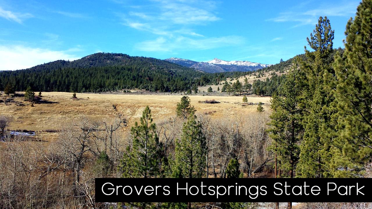
Sierra Rec Magazine – Trail Review by Tom Trelenberg – This trailhead is accessed off of Hot Springs Road, approximately 3 miles out of Markleeville, CA, about a mile before reaching Grover’s Hot Springs. The trailhead is outside the state park and adds about 20 minutes (one way) to the hike, but does avoid Grover’s day use fee if that is important to you. The path to Grover’s is not overly difficult and my arrival at the trailhead inside the park was much quicker than I had anticipated. I do, however, believe that the mileage listed for Burnside Lake (6.5 mi.) is incorrect and upon completion of the hike, would estimate it should be closer to 5 miles This trailhead and its connection to the park can be found seen in the Grover’s Hot Springs park brochure (https://www.parks.ca.gov/pages/508/files/GroverHotSpringsSPWebLayout2015.pdf).

Upon arriving at the parking lot within Grover’s, the trail becomes a road for a time and is very flat and easy as it skirts the meadow central to the park. Eventually, the road and trail split (though the trail remains very wide) until reaching the fork leading to Burnside Lake. Not quite sure what the difference between Burnside Lake and Burnside Lake Road as the lake and the road to it from Hope Valley appear simultaneously at the end of the trail.
Following this junction the trail is easy to easy-moderate for half a mile or so, but then the challenge begins. The next mile consists of an unrelenting set of steep switchbacks that take you from a packed dirt trail through the trees to loose decomposed granite passing through manzanita bushes, all the while climbing aggressively. Having been to Grover’s during the summer months amid fairly warm temperatures, and given this hard climb and its unbroken exposure to the sun, I was glad to be making this trek in the cooler temperatures of early October. Which brings up the point of water. In spite of the cool temperatures, I went through more water than I normally do. While the easy portions are very easy, the hard parts require considerable exertion—I suggest packing a bit of additional water, especially if you are out on a warmer day. During the frequent rest pauses you will be making during this ascent, take the opportunity to look back into the valleys for some spectacular views.
Once the switchbacks end, the trail becomes a bit less steep and you reach the clearly marked Burnside Lake / Charity Valley split. Bearing right, you will be treated, briefly, to a relatively flat path. About 5 minutes down this path, a rock bridge crosses over a stream, providing the first shade you have had in a while and will have for a time moving forward—making it a great place to rest and have a snack.

The path then turns up into the valley that stream flows down, and remains fairly gentle except for the a short section connecting the bridge and the valley. Soon, however, the trail takes a westerly turn and begins to climb the valley wall. This section is even steeper than the earlier section but fortunately is shorter–taking me only about a half an hour as compared to close to an hour for the previous section. So steep is this path that on the return trip I took the same amount of time coming down (without slipping) as I did going up, even with all my rest stops. Additionally, though the trail is obvious (where your feet should go) the brush has begun to encroach heavily into where your body needs to be. I was again appreciative of my longer pants – my short-sleeved arms were significantly scratched.
Upon completing this section, the trail becomes so flat and easy, it is hard to believe the just-completed section existed. A fast and easy walk of about a mile will bring you to Burnside Lake; absolutely beautiful the day I was there and, surprisingly, without any other visitors.
While at the lake, you may want to go on a scavenger hunt for the Burnside Lake swing. My son and I found it 2 years ago while camping at the lake and he really enjoyed an unexpected swing. Take some time exploring the area east of the lake and maybe you can find it too
One of the things I try to assess on these hikes is how my sons, 10 and 13, would fare on them. They are reasonably good sports about length and difficulty, however, I think this would have been a bit much for them a year ago. But with some of their performances this past summer, I think that Burnside Lake would have been doable, but perhaps not enjoyable. By next summer, I think this will be hard, but enjoyable for them, being a bit older and more capable. They love to clamor over rocks and investigate nooks and crannies in them and there are ample opportunities here. Kids will need to be able to carry their own water as you will be carrying quite a bit just for yourself. Avid youngsters of 9 or 10 should be able to do this hike, but if your kids are like mine, I would suggest visiting the Grover’s waterfall until they are 11 or 12—by then I think they will be able to enjoy the sense of accomplishment of completing this trip. 


Comments 1