A central and historic part of Alpine County California, Markleville is a popular stop for travelers South of Lake Tahoe headed out for wilderness adventures and scenic drives. Highlighted by near by Carson Iceberg and Mokulumne Wilderness plus Markleville creek, Grover’s Hot Springs State park and the East Fork of the Carson river, locals and visitors have nearly unlimited options for camping in the region.
Alpine County as a whole has three dozen structured camping areas and thousands of acres of national forest, BLM land open to dispersed camping. on this page we will focus on Camping areas near the Town of Markleville and break out Paid location plus highlight a few of the regions most sought out dispersed camping spots.
A California Fire Permit is required for all campfires in this region. Gas stoves also may need a Campfire Permit. We suggest checking local restrictions with forest service before heading out. Campfire permits are available at the Visitors Center in Markleeville and online at www.preventwildfireca.org/campfire-Permit. Seasonal hours. Call for hours.
Regulated RV and Tent Camping Near Markleville
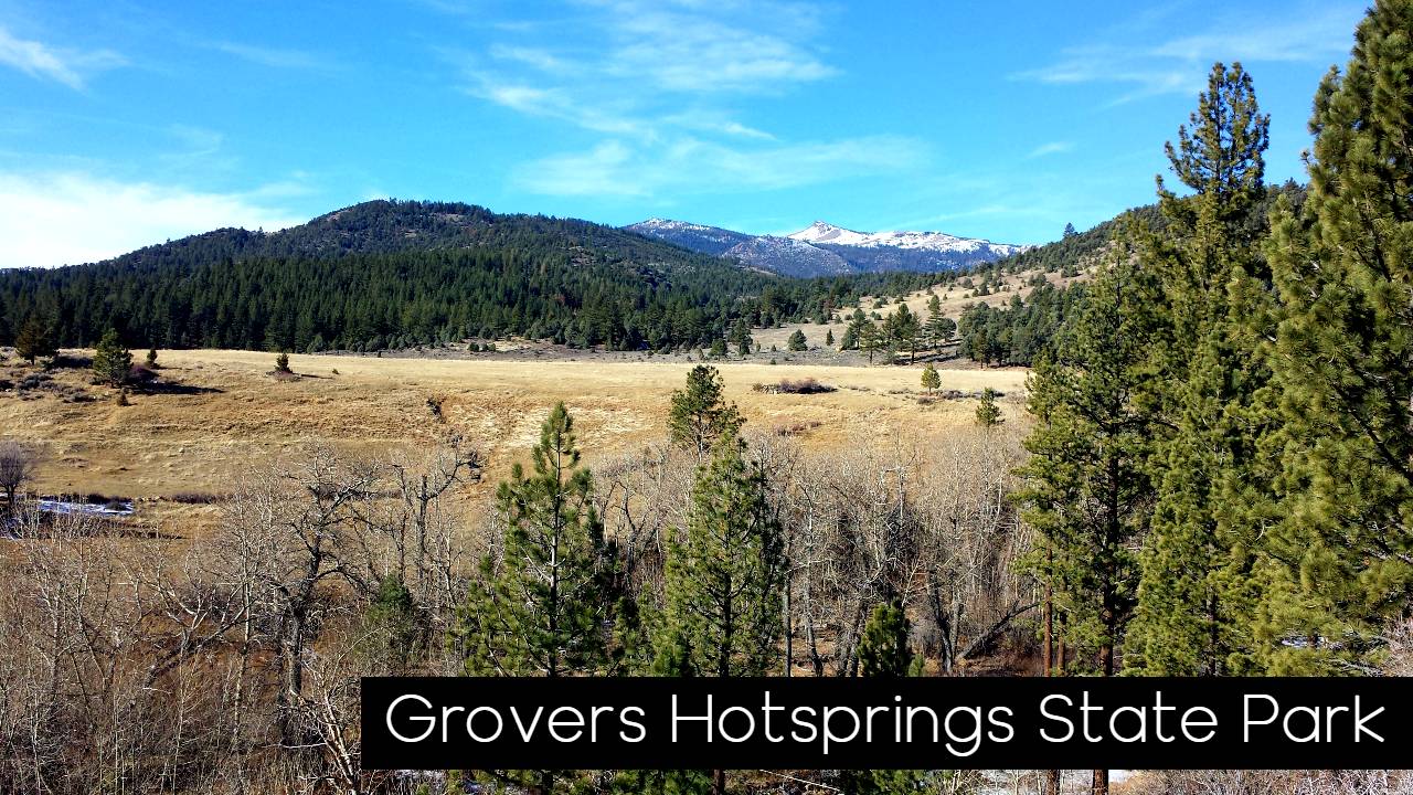
Grover’s Hot Springs State Park – Hidden in quiet Hot Springs Valley on the eastern side of the Sierra Nevada, Grover Hot Springs State Park offers alpine vistas of granite peaks and wildflower meadows just outside of Markleville ca.. After taking a brisk hike or a scenic stroll, visitors may soak in a mineral pool fed from six hot springs. The park offers both the hot pool and a cool swimming pool, a forested 76-site campground, picnic area, hiking trails, and fishing streams. -Camping is generally available year-round, conditions permitting. Our campground has 76 family sites and is on a reservation system typically from mid-May through mid-September. 2021 reservation dates are May 14 – Sept 13. Make reservations at ReserveCalifornia.com. After the reservation period is over, camping in the campground is first-come, first-serve until October. In October winter camping moves to picnic area near the park entrance, and the max length of RVs and trailers changes to 18 feet.
Turtle Rock Campground – Turtle Rock Park Campground is located near Markleeville, California at an elevation of 6100. The park has a combination of 26 RV or trailer sites, two of which are handicap accessible. There are also 12 tent sites. The picnic / day use area has a handicap accessible site.
The campground is open seasonally, approximately May through early October. The campground is available on a first come, first served basis. No reservations are available. All vehicles must park on the paved pad at the site. Water faucets are located at various sites, no other hook-ups are available. There is no dump station. The park offers flush toilets and a handicap coin-op shower. Also available for use on the property are a tennis court, basketball court, disc golf course, and horseshoe pit.

Markleville Campground – Located on Markleeville Creek, in the shade of Jeffrey pines and cottonwood trees. Generally open late April through early September as weather and conditions allow. Tent camping, Camping trailer ( Max Length 24 ft.) , Picnic tables, Toilets, Drinking water $18 a night
Indian Creek – Indian Creek Campground is nestled in the eastern foothills of the Sierra Nevada between the California towns of Woodfords and Markleeville. Elevation in the area ranges from 5,600 feet at the reservoir to 6,400 feet in the surrounding foothills. Pine trees and sagebrush dot the landscape. A campground with 30 sites is situated next to Indian Creek Reservoir. The campground has an RV/tent loop, a tent walk-to loop and group camp area. The RV/tent loop has 19 sites that are suitable for recreational vehicles up to 34 feet in length or tents. The walk-to tent loop has 10 sites with parking nearby. A group campsite (tents only) is available for groups of up to 40 campers. The main restrooms located in the RV/tent loop have flush toilets and hot showers. Drinking water is provided.

Silver Creek Campground – Silver Creek Campground is located in a scenic fir and pine forest on the mountainside just above Noble Creek at an elevation of 6,800 feet. Popular activities include fishing nearby creeks and the East Fork Carson River, and hiking on the Pacific Crest Trail, which can be accessed just 3 miles west of the site. This campground straddles Highway 4, creating two separate loops containing several single-family sites with picnic tables, fire rings with grills, and bear boxes. Vault toilets, potable water, and garbage service are provided. A campground host is located on-site; firewood is available for purchase. Roads and parking spurs are paved. Generally open from early June through early September as weather and conditions allow. $18 Night for single unit
$34 Night for double unit. Water Hook up not available.
| 22 sites, 1 double site, 22 RV sites | |
| Reservation Info | Reservations are required for most sites by calling toll free 877-444-6777 (International 518-885-3639 or TDD 877-833-6777) or online at www.recreation.gov. Sites 1, 12, 21, and 22 require no reservations and are first come first served. |
Carson River Resort (Private) – Located on Highways 4 and 89 on the east fork of the Carson River, 2.5 miles south of Markleeville, the southern gateway to Carson City and Lake Tahoe. Located on the East Fork of the Carson River, surrounded by the serene, age-old beauty of the Toiyabe National Forest, Carson River Resort is a popular stop frequented by campers, hikers, fisherman, and kayak enthusiasts alike. The resort’s rustic and quaint accommodations make for a genuine outdoor camping experience. Not to mention the spacious camp sites along the river allow for privacy, calm, and a chance to get in touch with the one of a kind Sierra Nevada wilderness. Cabins and RV spaces are also located just a short distance from the river.
River Side Camping Rates
$20.00 Daily off the River
$25.00 Daily on the River
$35.00 Daily for group site
$5.00 Daily for additional vehicle
There are 15 RV spaces available to rent. RV Spaces come with water, sewage, and electricity.$30.00 /day-weekdays, $35.00/day-weekends/holidays, $175.00 Weekly. Contact Carson River Resort for longer term rates. These rates are based on one RV and one car.
Carson River Resort’s convenience store is a one-stop establishment with all the appliances to assist you with your recreational needs whether it be fishing, camping, spirits, groceries, or even obtaining Pleasant Valley Fishing Permits and fishing and hunting licenses. Call for reservation: (530) 694-2229
Camping on HWY 88
- Woods Lake
- Caples Lake
- Silver Lake
- Blue Lakes
- Blue lake Highway
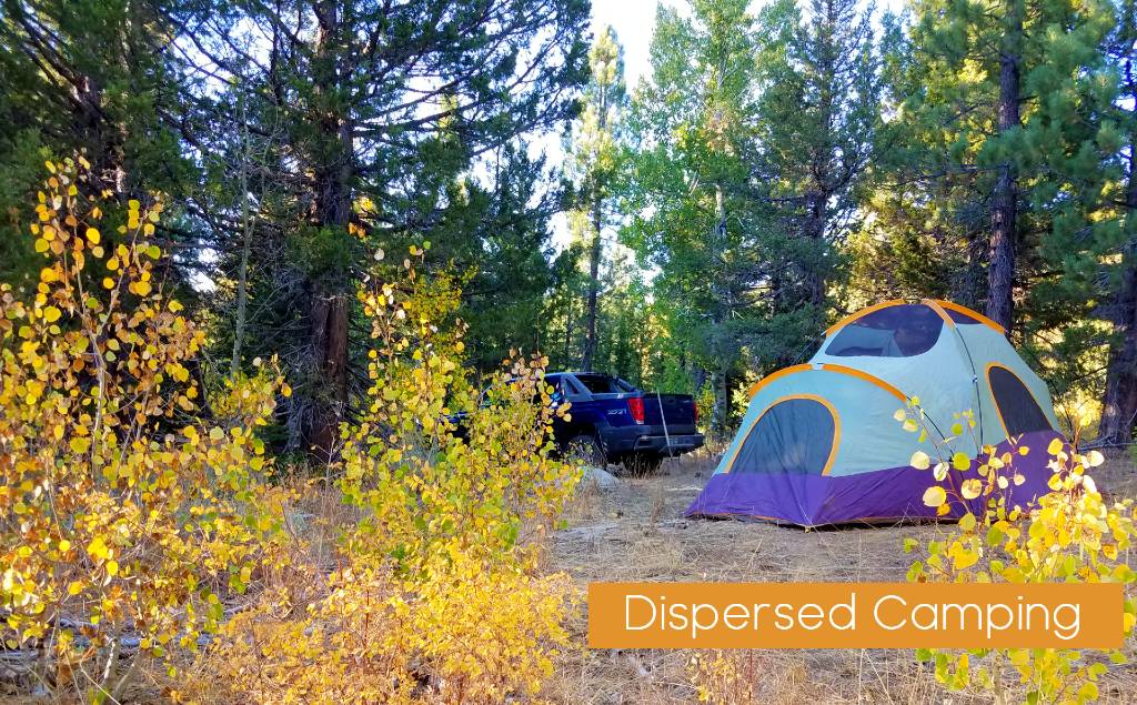
Featured dispersed Camping Locations – Locations that can be driven to in standard vehicles
Dispersed camping allows you to “get away from it all.” Peace, solitude and adventure are some of the advantages to choosing an undeveloped campsite. Since there are no facilities, you must bring your own water, camp at least 100 feet from all water sources and dig a hole at least six inches deep for disposal of human waste. Remember all Forest rules and regulations apply even in dispersed sites.
Centerville Flat – A very popular location for long stay dispersed camping near Markleville this area is at the junction of HWY 4 and Wolf Creek Cutoff approx. 7 miles outside of Markleville. Features several flat camping areas, the East Fork of the Carson and Silver Creek join here making it a popular fishing location as well. Vaulted Toilets are available. There are also several location located off Wolf Creek road with in the first 1/2 mile for turn off that serve this same area.
Wolf Creek Meadows – Wolf Creek Meadows is located at the boarder of the Carson Iceberg Wilderness and features great horse camping locations as well and tent locations at trailhead, plus some of the areas best backpacking area with incredible vistas, backcountry lakes and running streams all year round. To access wolf Creek take the Wolf Creek turn off at Centerville Flat 7 miles west of Markleville and follow road as it turns from pavement to dirt and crosses over a small range on the way into Wolf Creek meadow. The meadow itself is partially private land with grazing cattle. Their is camping at the end of the road or their is also camping at the High Trail trailhead located across the valley, road turns left near the ranch house and crosses the Wolf creek before climbing slightly out of the valley.
Poor Boy / Indian Creek – Indian Creek and Poor boy Road follows forest service road back into India creek Valley. Poor Boy Road exits south of Markleville off HWY 89 and travels dirt road along Indian Creek until eventually climbing the ridge again back into old mining region of the range.

East Carson River Roadside – There are many roadside camping locations along the East fork of the Carson River. throughout the summer you will find RV and tent campers all along the highway in very established access roads. The East fork is a popular fishing destination so spots do fill up quickly.
Silver Creek Roadside – Continue past Centerville flat a few more miles you will reach an area called Silver Creek Valley. This segment is the final flat region before climbing into Ebbett’s pass. Similar to the East Fork these site all rest on the Silver creek and feature great forested locations to pitch your tent, car camp or pull in an RV.
Top Backpacking or Trail Dispersed Camping Locations
High trail – Carson Iceberg Wilderness
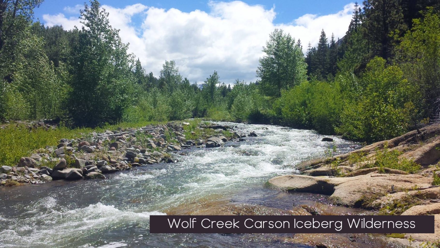
Wolf Creek – Carson Iceberg Wilderness
Charity Valley Trail –
Monitor Pass
Heenan Lake to Carson Iceberg Wilderness
Check out some of our Camping Articles:
- The Best Foods To Bring on a Camping Trip
- Things You May Not Realize You Need on Your Camping Trip
- Tips on What To Pack on an RV Camping Trip
