Ok it might be cheating to list out the top 15 destinations and trails for Tuolumne County, since it includes Yosemite National Park North side and Emigrant Wilderness, but hey not all counties are created equal!
Tuolumne County stands as a pristine and captivating outdoor haven, inviting adventure seekers and nature enthusiasts alike. Renowned for its breathtaking landscapes, this Northern California gem boasts an array of outdoor destinations and trails that beckon exploration. In our exploration of the 15 Great Outdoor Destinations and Trails in Tuolumne County for Sierra Rec Magazine, we’ll delve into the region’s rich landscape of outdoor opportunities. From challenging mountain trails that reward hikers with panoramic vistas to serene lakeside retreats perfect for fishing and relaxation, Tuolumne County promises an unforgettable outdoor experience for nature lovers of all levels. Join us on a journey through this captivating landscape, where every trail tells a story and every destination is a testament to the unparalleled beauty of the Sierra Nevada.
So here are our top 15 destinations/ trails to visit on your next travel into Tuolumne’s adventure rich country.

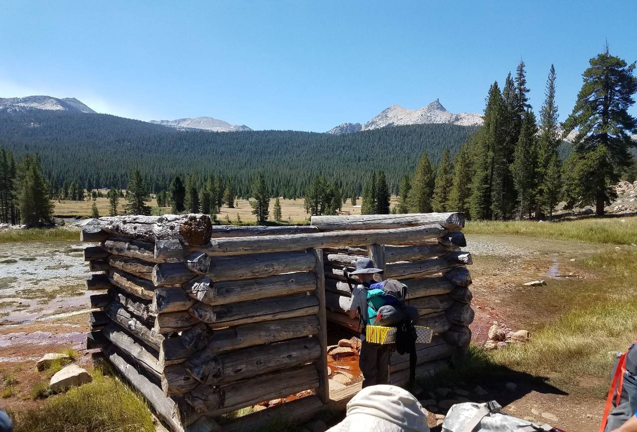
PCT Trail – Tuolumne Meadows to Glen Aulin
This 5.5 mile one way trip is a fantastic visit in Yosemite National Park and the far South eastern edge of Tuolumne County. Relatively flat for the first 4 miles, enjoy panoramic views of Cathedral range, wildlife in Tuolumne Meadows and the relaxing sounds of the calm Tuolumne river stretch. Then enjoy a very scenic 1.5 mile climb down the start of the Grand Canyon of Yosemite to Glen Aulin high Camp passing Tuolumne falls along the way.
Yosemite National Parks Soda Springs and Lembert Dome
Weekend adventures looking for a little Yosemite magic not far from the car will enjoy this historic route to Soda Springs to enjoy what original ranch life in Yosemite was like and to visit the famed Soda Water springs. Looking for a little extra adventure take the Dog lake trail from here and circle back to the top of Lembert Dome, one of the most scenic and iconic 360 views of Yosemite.

Wapama Falls Rancheria Falls Trail at Hetch Hetchy Reservoir
One of the most overlooked trail experiences in Yosemite National park is the trek along the shores of Hetch Hetchy reservoir to Wapama falls. described by many as the twin to Yosemite Valley, Hetch Hetchy is the crown jewel of central California water supply, so the crystal blue waters have neither boats or swimmers lurking on the shores. Instead visitors can enjoy a 5-mile portion of this trial which provides spectacular sights of Tueeulala and Wapama Falls. More seasoned adventures can add an additional 8 miles out to Rancheria falls. popular for backpackers.
Carlon Falls
Enjoy the easy to intermediate 2.8 mile round trip hiking trail along the South Fork of the Tuolumne River into the Yosemite Wilderness Area to Carlon Falls. Have a picnic and cool off with a refreshing swim.
This trail begins on the Stanislaus National Forest at the Carlon Day Use Area off of Evergreen Rd. Since the trail enters the Yosemite Wilderness Area, biking and dogs are not allowed.
Sonora Pass / Scenic Route 108
Kennedy Lake Trail
Kennedy Lake Trail is a 15.5 mile heavily trafficked out and back trail located of Sonora Pass and has an elevation gain of 1900 feet to the lake is rated as difficult. The trail offers a number of activity options and is best used from June until October. Dogs and horses are also able to use this trail. Kennedy lake features lush meadows, raging water, granite , historic mining area and typical refreshing mountain lake at 7884′
Relief Reservoir
Relief Reservoir Trail is a 7.2 mile moderately trafficked out and back trail located near Pinecrest, California that features a lake and is rated as moderate. The trail offers a number of activity options and is best used from May until October. Dogs are also able to use this trail but must be kept on leash. A great hike for beginning backpackers, this trail includes Kennedy Meadows and the Relief Reservoir with amazing mountain and lake scenery.
Pinecrest Loop Trail
The popular trail loops the entirety of Pinecrest Lake total distance of 3.9 miles and crosses the Stanislaus River and the dam. This trail offers lots of up and down boulders, but well worth it for the views especially from the halfway point! The dam can be fun to traverse and the granite cliffs before the dam are amazing. Pinecrest is a popular little lake. There are many activities and people, but not a lot of parking. Best to arrive as early as possible get parked and set up. dogs are not allowed on this trail during peak season
Chewing Gum Lake via Gianelli Trail
Chewing Gum Lake is a beautiful little camping spot not far inside the Emigrant Wilderness. It’s not a fishing lake, but it can have spectacular sunsets and offers good swimming. The 4.5-miles hike to Chewing Gum Lake passes among wildflowers and has panoramic views of the Stanislaus River watershed.
Chewing Gum Lake is best done late in the summer when the snow has melted and the mosquitoes have died off. Because of its proximity to Pinecrest it makes a nice overnight backpacking trip for anyone staying at a nearby cabin.
Crabtree Trail to Bear Lake
Crabtree Trail to Bear Lake is a 8.3 mile heavily trafficked out and back trail located near Mi Wuk Village, California that features a great forest setting and is rated as moderate. Crabtree Trail is a great hike to the beautiful Bear Lake. It starts with a big incline but after a while it levels out. During summer it’s great to take a swim and relax in some shade. This is an excellent option if this is your first time backpacking, or if you are training for a bigger backpack trip. You can take a rest once you reach Camp Lake, a little more than halfway to Bear Lake.
Tuolumne Gold Country

New Melones Lake
New Melones Dam and Reservoir are part of the Central Valley Project – New Melones Unit operated by the Bureau of Reclamation. Located 60 miles upstream on the Stanislaus River from the confluence of the San Joaquin River. The reservoir has a capacity of 2.4 million acre feet of water with 100 miles of shoreline, and a water surface area of 12,500 acres. New Melones is located between the historic mining towns of Sonora and Angels Camp on Highway 49 and is nestled in the Foothill Oak Woodlands of the Sierras at the 1100 ft elevation. Summer temperatures range from 85-100F and winter range from 32-60F.Gloryhole Recreation Area has two campgrounds (Big Oak and Ironhorse) with 144 campsites, 3 day-use areas, 30 miles of hiking/biking trails, a fish cleaning station, a swim beach, and 2 boat launch ramps with parking lots. A full service marina and store complete with fuel and boat rentals are available.
Table Mountain Trail
The trail starts at the metal gate on Shell Road. It loosely parallels Shell Road for about a mile skirting some of the green meadows on the west side of the road. Cross the road and start heading uphill toward the flat mountain right in front of you. Total distance on trail 1.6 miles
The ascent is initially moderate but then turns into very steep boulder climbing at 1.4 miles. Just continue uphill until you reach the flat surface. Table Mountain provides stunning views of New Melones Lake and the wildflower covered top invites you to just stroll and explore
Dragon Gulch
Located in the City of Sonora, the Dragoon Gulch Trail provides its visitors with a unique opportunity to stroll through the Mother Lode’s oak woodlands. The Dragoon Gulch Trail provides over 3.1 miles of natural trails. The trails travel along a natural creek up to the vista that provides a spectacular view of the City and its surrounding mountain ranges. The trails vary in difficulty making it perfect for the casual walker and for those who want a strenuous hike or jog. LENGTH – 3.1 miles of trails
Westside Railroad Trail
The West Side Trail, just outside Tuolumne, California, has been enjoyed by local residents and visitors for many years. In 2012, several agencies joined together to create interpretive panels that would provide visitors a glimpse of the history that makes this trail so special. Those who explore this trail know it was from a former railroad. A few hikers may even know it was a narrow-gauge railway from the glory days of the West Side Lumber Company. But only a handful of visitors can tell you of the rich tales that this trail holds.
Sugar Pine Trail Twain Harte to Lyons Reservoir
The year-round trail is a family and dog friendly option primarily used for hiking, walking and running. The trail offers water features, a wide gravel path plus surrounding trees which provide plenty of shade. This trail is the first 5 miles of a longer trail that was built upon an abandoned railroad grade that runs from Twain Harte up to the community of Strawberry. Along the way, this portion of trail will pass the community of Sugar Pine, and the Lyons reservoir. This relatively flat trail winds its way through conifer forests, moving along on an easy doubletrack with the hillside high above the canyon below. Sweeping views of the surrounding mountains can be had at several locations along its route.
Ferretti Road Non-Motorized Trail Network
Trail network includes a 1.3 mile bike-only loop with optional features and views into Yosemite and the Tuolumne River Canyon. The Ferretti Non- Motorized Trail System is a Mountain Bike Destination Trail System and our pilot project in partnership with the USFS, Stanislaus National Forest, Groveland Ranger District. It’s located off Ferretti Road in Groveland on 500+ acres within the Groveland Ranger District of the Stanislaus National Forest. This project is currently undergoing environmental studies though we have a conceptual trails plan as well as a map(see map)of the proposed trail system. There are already multi-use trails and Forest Service dirt roads in use now that will be added to the trail system.

Leave a Reply