Welcome to the Mokelumne Wilderness
The 105,165 acre Mokelumne Wilderness straddles the crest of the central Sierra Nevada, within the Stanislaus, Eldorado, and Toiyabe National Forests. This area lies within portions of Calaveras, Alpine, and Amador Counties and is bordered by State Highway 4 on the south and State Highway 88 on the north. Watersheds drain to the Mokelumne River on the west slope and the Carson River on the east slope. New Management Guidelines were recently adopted for the Mokelumne Wilderness.
The Mokelumne Wilderness is a rugged landscape of great scenic beauty. Much of the area is dominated by volcanic ridges and peaks. The prominent feature is disputably the rugged Mokelumne River Canyon. There are many smaller streams flowing through deep granitic canyons but only a few lakes concentrated in the northern portion of this spectacular area. Elevations range from about 3900 feet near Salt Springs Reservoir to 10,380 feet at Round Top. Precipitation averages 50 inches annually on the west slope and as little as 15 inches on the east slope, 80 percent of it in the form of snow. Snowcaps typically linger into June in the Round Top region to the north and on the Mokelumne Plateau to the south, while the Mokelumne River Canyon above Salt Springs Reservoir can be free of snow as early as March. Summers are generally dry and mild, but afternoon thundershowers occur periodically and nighttime temperatures may dip below freezing any time.
New to Backpacking? you might check out this resource for beginning backpacking and wilderness exploration.
Backpacking Trails Inside the Mokelumne Wilderness from the Eldorado National forest Side of the Wilderness
- Tanglefoot Trail 17E29
- Granite Lake Trail 17E23
- Munson Meadow Trail 17E27
- Horse Canyon Trail 17E21
- Grouse Lake Trail 18E08
- Summit City Trail 18E07
- Evergreen Trail 18E21

Carson Pass / PCT
The most popular trail in the Mokelumne wilderness is the the access point from Carson Pass via the PCT. into Winnemucca Lake and Round top Lake with backpackers heading into Fourth of July Lake
Tanglefoot trail
This trail traverses forests, meadows, and the Tanglefoot Canyon, skirts the west and north slopes of Mokelumne Peak, descends past a spring and gradually regains elevation to end at Munson Meadow, 10.1 miles from the Tanglefoot Trailhead.
Directions:
Turn south off of Highway 88 at the Bear River Reservoir Road. Travel approximately 4.5 miles, go left on Road 08N14. Before reaching Cole Creek Campground, take a left (still on Road 08N14), and continue to a large turnaround which is preferred for stock trailers. The trailhead is an additional 1/4 mile.
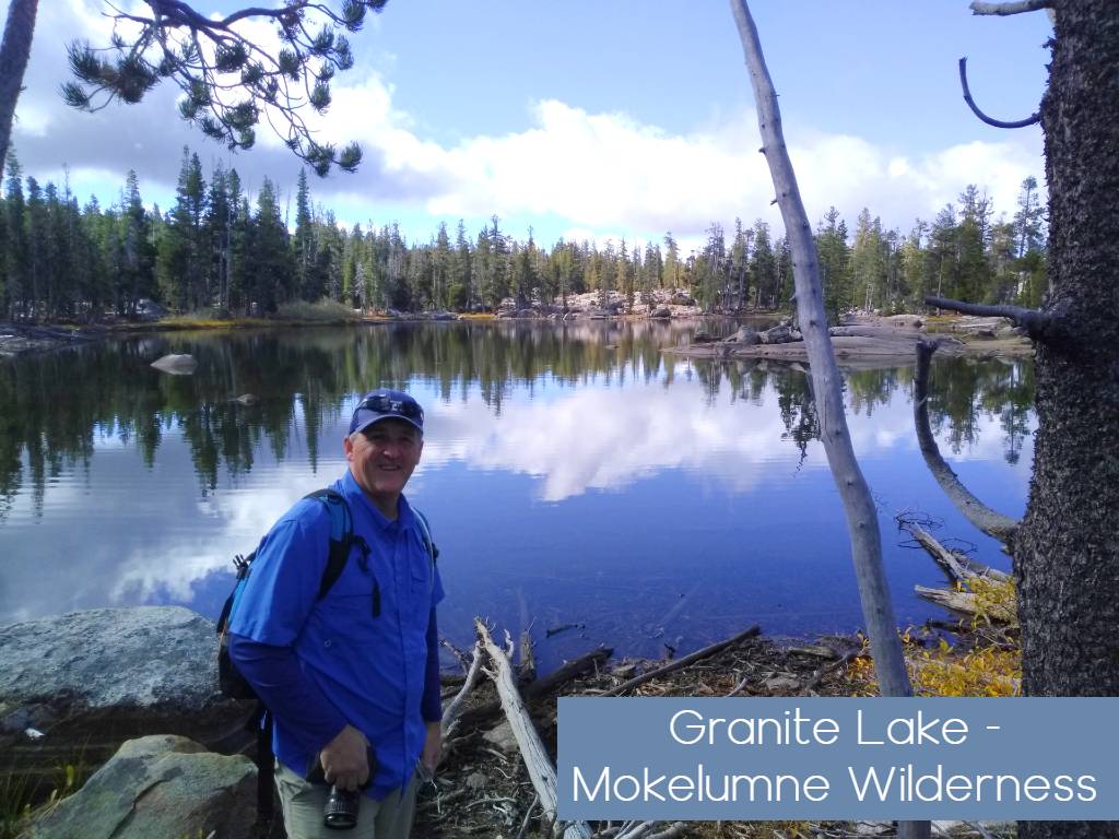
Granite Lake Trail
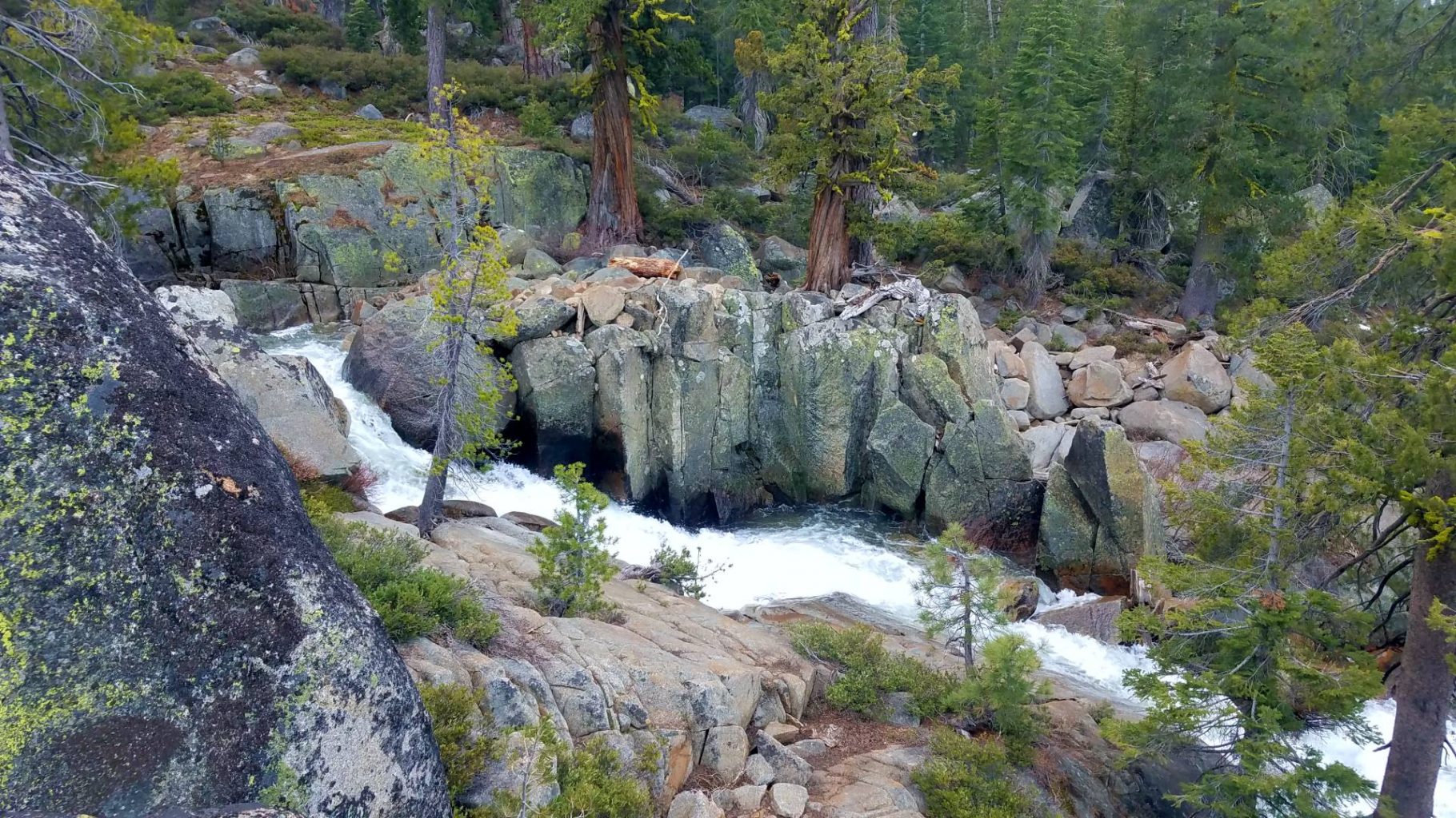
The trail starts off on the Minkalo Trail to a junction in 0.6 miles, then turns left toward Granite Lake where it arrives at 1 mile. Along the way, the trail crosses a bridge over an unnamed creek with an impressive waterfall. Past Granite Lake, the trail traverses numerous granite slabs and enters the forest, following the contour and arriving at Hidden Lake at mile 3.8.
Directions:
Turn off of Highway 88 at the sign for Kit Carson Resort. Bear left at the first “Y”, and right at the second “Y”, following the signs for Granite Lake. A small trailhead parking area is located at the end of the road.
Munson Meadow trail
This 9.1 mile trail to Camp Irene traverses open forests and meadows for 5 miles to Munson Meadow, then another 4.1 miles through forest and brushy terrain before meeting the Mokelumne River. Access to Black Rock Lake, Cole Creek Lake and Long Lake as well of this trail.
Directions:
Access to the trailhead is from Squaw Ridge, south of Highway 88. The Squaw Ridge (Mud Lake) Road begins on Highway 88 across from Tragedy Springs. Check with Amador Ranger Station for current vehicle access restrictions.
Horse Canyon trail
The trail leads from the Horse Canyon Trailhead through an old-growth forest before following a dry gully as it ascends 3.1 miles to meet the Thunder Mountain trail, then traverses meadows and forest to meet Squaw Ridge at mile 5.3, descending through brushy terrain to reach Summit City Creek at mile 8.6. – many hikers and horseback teams will make this a loop trip by connection with Thunder mountain then crossing highway over to Castle Peak ridge and back down to Horse Canyon trail.
Directions:
Turn off of Highway 88 at the Horse Canyon Trailhead, between Silver Lake and Carson Spur.
Grouse Lake trail
The trail, in the Mokelumne Wilderness after the first mile, passes Granite Lake (2 miles) before reaching Grouse Lake (5.6 miles). Starting off in open forest, the trail is nearly treeless for the last 3 miles. Climb up out of the Blue Lakes basin. Great day hike if camping at blue lakes, but better back packing destination if you don’t want the crowds. Similar in nature to Fourth of July Lake you will climb and ten Descend into the lake basin some 700 feet. Last few miles trail is not easy to find. Map skills needed. If backpacking at Granite Lake consider off trail excursion to Evergreen lake for less crowds.
Directions:
From Highway 88, take the Hope Valley Road to Lower Blue Lake and turn north until you reach the south end of Upper Blue Lake (trailhead).
Summit City trail
Starting from Forestdale Divide, the trail leads downhill through meadows and open forest past an area that was once an active mining community. The trail continues to the junction of the trail leading uphill to Fourth of July Lake.
Directions:
From Highway 88, take the Hope Valley Road to Lower Blue Lake and turn north. In 3 miles the dirt road turns to 4WD, and in 2 miles reaches the Forestdale Divide trailhead.
The Evergreen Trail
The Evergreen Trail starts near Upper Blue Lake campground and proceeds over a small pass and down into Summit City Canyon near the site of an old mining community. It crosses Summit City Creek and joins the Summit City trail (to Forestdale Divide) and Camp Irene trail (which continues down Summit City Creek). Expect brushy conditions and fallen trees across trail west of the 4th of July Lake junction. The trail is not maintained past Telephone Gulch.
Directions:
From Highway 88, take the Hope Valley Road to Lower Blue Lake and turn north. In 3 miles the dirt road reaches the Evergreen Trailhead.
Backpacking Trails Inside the Mokelumne Wilderness from the Stanislaus National forest side of the Wilderness
Lake Valley trailhead
This trailhead provides access to Lake Valley and Camp Irene. It is 5.1 miles to Camp Irene. Very steep trail with many slopes and switchbacks. Mokelumne River access/pools. No water until you reach the river. No cows. In Mokelumne Wilderness.
Trailhead is accessible for highway-legal 4×4 high clearance vehicles only, very rough road (not all wheel drive accessible). Parking for non-4×4 vehicles is available at Round Valley SNO-PARK.

Elevation: 7548 feet.
Directions:
From the Calaveras Ranger Station in Hathaway Pines, California, head east on highway 4 for approximately 32.5 miles and turn left when you see the sign for Highway 207 Bear Valley Ski Area. Follow this for .2 miles then turn right into the Round Valley SNO-PARK. Staging and hiking out from here is possible, but keep in mind between November 1 and May 31 a SNO-PARK permit is required.
If you have a highway-legal high clearance 4×4 vehicle it is possible to drive 2.6 miles to the trailhead. Very rough road (not all wheel drive accessible). Parking for non-4×4 vehicles is available at Round Valley SNO-PARK.
Deer Creek Trail
Starts at the west end of Hermit Valley and runs along the Mokelumne River to its confluence with Deer Creek. River views at the beginning of the trail, then descends into forest and over rock outcrops. 1.6 miles one-way. Strenuous. Trail enters the Mokelumne Wilderness at about the halfway point.
Directions:
Trailhead is at the west end of Hermit Valley, 5.5 miles west of Ebbetts Pass on Highway 4.
From the Calaveras Ranger Station in Hathaway Pines, California, head east on Highway 4 for about 43 miles. After you cross the bridge over the Mokelumne River, turn left into the parking area. Accessible to all highway-legal vehicle types, native surface parking area. Trailhead is near the road and the east side of the bridge.
Trailhead access by car is blocked by snow and road closure of Highway 4 in the winter season.
Deer Valley / Stevenot Camp Trail
This trail follows the Deer Valley OHV trail for about a mile before veering off to the left. In the fall this trail is mostly used by hunters.
Elevation: 7096
Lat/Long: 38.539014, -119.896799
Directions:
From the Calaveras Ranger Station in Hathaway Pines, California, head east on Highway 4 for about 43 miles. When you see the sign for Hermit Valley, turn left into the parking area and make your way to the back and to the right. There are several signs marking the trailhead. Accessible to all highway-legal vehicle types, native surface parking area.
Trailhead access by car is blocked by snow and road closure of Highway 4 in the winter season.
Sandy Meadow trailhead
This trail can be used to access Wheeler Lake; it is flatter and easier than the Wheeler Ridge/Lake Trail out of Woodchuck Basin but longer. It is 4.2 miles to Wheeler Lake. In Mokelumne Wilderness.
Elevation is 7923 feet
Directions:
From the Calaveras Ranger Station in Hathaway Pines, California, head east on Highway 4 for about 39 miles. The trailhead sign on the right-hand side of the road is where the parking area is located. The trailhead is on the opposite side of the road.
Accessible to all highway-legal vehicle types, native surface small parking area; must cross highway to get to the trail.
Woodchuck Basin trail
Woodchuck Basin is the trailhead for the Wheeler Ridge/ Wheeler Lake Trail (on maps as the Woodchuck Trail, 18E24 and Underwood Valley Trail, 18E02), which leads to Wheeler Lake and Avalanche Meadow. The trail connects with the Sandy Meadow Trail (19E53), which passes through Sandy Meadow and ends at the Sandy Meadow Trailhead.
Directions:
From the Calaveras Ranger District head east on Highway 4 for approximately 35 miles; parking is on the left, right off the highway. Accessible to all highway-legal vehicle types, native surface parking area.
Lat/Long: 38.4933, -119.9808
Permits are mandatory for entry into the Mokelumne Wilderness year round for overnight use.
The permit system allows the Forest Service to inform visitors of their responsibilities for preserving the wilderness resource, gather important recreation use data, and to limit use where necessary. Permits can also be helpful in locating people during emergencies. Organized commercial or institutional groups will also need an Outfitter-Guide permit: contact the local Ranger Station for more information.
Overnight Permits: Required year-round.
Day-Use Permits: None.
Maximum group size: 12 people for day-use, and 8 people for overnight use.
- If you have a larger group than is permitted, reduce the number of people, split the group to visit different areas, or visit an area which permits larger numbers. You are not permitted to camp or travel within one mile of a related group.
Other Permit Information:
- Only one permit is required per group and must remain with someone in the party at all times.
- Each permit is good for one trip only.
- You must enter at the trailhead designated on your permit.
Campfires: NOT ALLOWED in the Carson Pass Management Area (CPMA). Camp stoves are permitted with a valid California Campfire Permit. Note: Fire restrictions are in place for the entire Eldorado National Forest.
How to Obtain a Permit
Carson Pass Management Area (CPMA): (Lake Winnemucca, Round Top Lake, and 4th of July Lake) and the Eldorado National Forest portion of the Mokelumne Wilderness:
Email: SM.FS.mokewild@usda.gov requesting a permit. A fillable permit will be emailed to you with instructions. Fill out the permit, print, sign, and email to back to SM.FS.mokewild@usda.gov.
Virtual office hours are Monday through Friday 8:00 am to 4:30 pm and permits can only be requested/created during regular business hours. Offices are closed on Federal Holidays and weekends. Please, email during regular business hours; planning your trip before the weekend.
Carson Pass Information Station & the Amador Ranger District Office: The Station at the pass and the office on Silver Drive in Pioneer, CA will remain closed for the remainder of the 2020 season. No permits are being issued in person.
Parking: A Snow Park permit to park is required for parking at Carson Pass and the Meiss Trailheads from November 1 through April 30. Please have the permit placed on dashboard of vehicle. Purchase and print from the website, do not relay on vendors being open and selling. Call the vendor first. This is a California state managed program. CHP will be patrolling the parking lots ($94.50 fine), and Cal Trans will be plowing. Keep a close eye on the Cal Trans chain control and road closure website, and the NOAA-7 Day Forecast.
Snow Camping: CPMA must have a minimum of 12 inches of snow on the ground to snow camp. Carson Pass- Snowshoeing & Cross Country Skiing information can be found here.
Group size: Limit 8 people per permit, and one permit per person. Day hiking, limit 12 people.
Camping spot: 200’ away from water, do not cause resources damage, stay in an existing tent pad.
Carson Pass Management: No Campfires are allowed! Camp stoves okay with valid California State campfire permit. Ready for wildfire.org
Frog Lake is open for day hiking but not overnight backpacking. This is considered part of the CPMA area, but is closed to overnight camping to preserve the shoreline.
Winter Snow Camping at Frog Lake is allowed once the snowpack is 12 inches deep.
Woods Lake is open for day hiking but not overnight backpacking. This Lake is a developed area with a developed campground, day use area, and has private leased cabins. Overnight camping is only allowed at the Woods Lake developed campground (closed for the season).


Leave a Reply