Yosemite’s South Border is a an area of rich history and beautiful landscapes. Day hiking in the Wawona area gives hikers of all levels options for some incredible adventures.
“Wawona is like a bright green emerald set between the sparkling diamonds of Yosemite Valley’s waterfalls and the red rubies of the Sequoias in the Mariposa Grove.” – Yosemite visitor, early 1900s
Although Wawona was not added to Yosemite National Park until 1932, this large mid-elevation basin has hosted many people and activities for centuries and is home to numerous other natural features. Originally home to American Indians, the Wawona area later became a prosperous settlement and primary thoroughfare for people traveling to Yosemite Valley during the late 19th century. Galen Clark, the first state-appointed guardian of Yosemite, built Clark’s Station, which later grew to become the Wawona Hotel.

Easy Hikes
Wawona Meadow Loop – Begin at the Wawona Hotel
3.5 miles (5.6 km) round trip
1.5 to 2 hours
Walk on the paved road across the Wawona Golf Course. Once across the golf course, take a left at the sign-posted trailhead. The trail is an unpaved fire road which loops around the meadow and returns to the Wawona Road.
A relaxing and scenic stroll, this trail offers views across
Wawona Basin and opportunities to see wildlife and wildflowers. Please note that horses, bikes, and leashed pets are allowed on the trail.
Moderate Hikes
Swinging Bridge Loop – Begin at Wawona Store / Pioneer Yosemite History Center parking area / or at the end of Forest Drive
4.75 miles (7.6 km) round trip
2 to 3 hours
1 mile round trip from end of
Forest Drive
30 minutes
The paved road, Forest Drive, leads 2 miles (3.2 km) upstream from the Pioneer Yosemite History Center to the Seventh Day Adventist Camp. At the camp, bear to the left onto the dirt road and continue 1/2 mile
to the Swinging Bridge. Cross the bridge and bear left onto the trail which becomes a dirt road and then Chilnualna Falls Road. This road will return to the Pioneer Yosemite History Center at the Wawona Stable.
Cross the covered bridge to return to the parking area. Most of this trail is along roads. ALTERNATIVE: Drive the two miles to the end of Forest Drive and hike 1/2 mile one-way to Swinging Bridge.
Wawona to Mariposa Grove – Begin at the Wawona Hotel
6 miles (9.6 km) one way to the
Grizzly Giant in the Mariposa
Grove
3 hours (2,400 ft / 732 m
elevation gain)
The trail begins behind the last uphill building of the Wawona Hotel—Moore Cottage. Look for the trailhead 50 yards uphill marked by the sign, “Mariposa Grove.”
If operating, ride the free shuttle from the Mariposa Grove back to the Wawona Store. You can also do this hike in reverse and take the free shuttle to the Mariposa Grove and hike downhill back to Wawona. Another option is to begin this trail from .25 miles up Forest Drive, where the trailhead will be on your right.
Mariposa Grove of Giant Sequoias -Begin at Mariposa Grove parking area. No pets or bicycles allowed beyond parking area
Grizzly Giant Tree and California Tunnel Tree: 1.6 miles (2.5
km) round trip, 1 hour (400 ft /
122 m elevation gain) Wawona
Point: 6 miles (9.6 km) round trip;
3 to 4 hours (1,200 ft. / 366 m
elevation gain) Outer Loop Trail:
6.9 miles (11.04 km); 4 to 5 hours
(1,200 ft / 366 m elevation gain)
Various trails exist throughout the Mariposa Grove. To reach the Grizzly Giant, follow the trail that begins at the far end of the parking area. From there climb uphill through the lower portion of the grove to reach
the Grizzly Giant Tree and the California Tunnel Tree, which is just 50 yards (50 meters) beyond the Grizzly Giant. To continue to the museum (open summer only) continue through the Tunnel Tree further into the grove.
Once in the upper grove, you may choose an alternate trail down, or continue on to Wawona Point before heading back to the parking area. Since parking at the trailhead is limited, consider taking the free
shuttle bus from Wawona (in summer only). Carry lots of drinking water in the summer, when temperatures can be extreme.

Mariposa Grove Hikes
- Big Trees Loop Trail (easy) – 0.3 mile (0.5 km); 30 to 45 minutes (wheelchair accessible) – Begin at Mariposa Grove Arrival Area – Winding through a forest with many giant sequoias, this trail features the Fallen Monarch and interpretive panels on the life and ecology of giant sequoias. This loop is relatively flat and is wheelchair accessible.
- Grizzly Giant Loop Trail (moderate) -2 miles (3.2 km); 1.5 to 2 hours. 300 feet (91 m) elevation gain Begin at Mariposa Grove Arrival Area -Start along the Mariposa Grove Trail at the Big Trees Loop and hike past notable trees such as the Bachelor and Three Graces, the Grizzly Giant, and California Tunnel Tree. Allow two hours to enjoy the full loop that winds along the edge of the grove and includes 300 feet (91 m) of elevation gain. Visitors with a valid disability placard can drive as far as the Grizzly Giant parking area and enjoy this area of the grove via a section of trail that is wheelchair accessible.
- Guardians Loop Trail (strenuous) -6.5 miles (10.5 km); 4 to 6 hours. 1,000 feet (305 m) – Begin at Mariposa Grove Arrival Area -From the tranquil upper portion of the grove, a 1.5-mile (2.4 km) loop takes hikers past many unique features such as the fallen Wawona Tunnel Tree, the Telescope Tree, and the Mariposa Grove Cabin.
- Mariposa Grove Trail to Wawona Point (strenuous)– 7 miles (11.3 km) round trip; 4 to 6 hours. 1,200 feet (366 m) elevation gain – Begin at Mariposa Grove Arrival Area -This wide and relatively smooth trail follows a route that people have used to access the grove for generations. See famous sequoias such as the Bachelor and Three Graces, the Faithful Couple, and the Clothespin Tree along this somewhat strenuous route to the upper reaches of the grove. Continue to historic Wawona Point, an overlook with panoramic views.
Strenuous Hikes
Alder Creek -Begin at Alder Creek Trailhead parking area; located .4 miles up Chilnualna Falls Road
12 miles (18.7 km) round trip to
Alder Creek. 6 hours (2,500 ft /
762 m elevation gain)
The trail leads from the parking area across the road and heads uphill north through an open pine forest with
abundant manzanita growing on drier slopes. The trail provides access to Alder Fall, a little-visited, 100-foot
cascade. Carry lots of drinking water in summer, when temperatures can be extreme. ALTERNATIVE: Begin at
Mosquito Creek along Wawona Road (hike is 8 miles round-trip to Alder Fall).
Chilnualna Falls -Begin at Chilnualna Falls Trailhead parking area located two miles up Chilnualna Falls Road
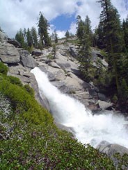
8.2 miles (13 km) round trip
5 to 6 hours (2,400 ft /
732 m elevation gain)
The trail leads from the parking area across the road and along Chilnualna Creek for 1/2 mile (.8 km). A series
of switchbacks lead away from the creek into the open forest. The falls are comprised of five large cascades
sliding through and over rock formations above the Wawona Basin—water here is fullest in spring and early
summer. Carry lots of drinking water in the summer, when temperatures can be extreme.
Other Yosemite Hiking Guides
- May Lake at Sunrise in Yosemite
- 10 Great Day Hikes off Tioga Pass and HWY 120 Tuolumne Meadows in Yosemite
- 1 Day Itinerary Yosemite Valley

Leave a Reply