
A Three Day Backpacking trip from the Leavitt Meadow Trailhead into Hoover Wilderness
In my 15 years living in the Sierra Nevada, Leavitt Meadow’s access to the Hoover wilderness has been a prevalent summer theme for me, to a point. The reality is that up until this past weekends backpacking trip into the West Walker River basin, I had never been past the set of four lakes less than two miles from Highway 108 ( Lane, Roosevelt, Secret and Poore Lakes)
A popular Eastern Sierra Backpacking and Day hiker region because of the variety of mountain lakes and backcountry features that the Hoover wilderness and Toiabye National Forest share in the Leavitt meadow region. We were excited to take three days, explore further into the wilderness area, and see what the West Walker River basin had in store for those who venture.

West Walker River Basin
The West Walker River Basin swings South of Highway 108 and East of Sonora Pass. It streams from high in the Sierra in Hoover Wilderness to the Toyiabe National Forest 15 miles North of Bridgeport, California.
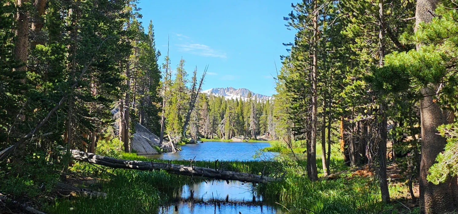
Inside the basin are several lakes, seasonal waterfalls and multiple river spurs that divide the region into great explorable zones for backpackers and horseback exploration. When backpacking off the Leavitt Meadows trailhead, hikers follow the West Walker River for the first few miles as the trail leads visitors to Roosevelt and Lane Lakes just inside the border of Hoover.
After leaving the two popular fishing and camping lakes, the trail heads further South, climbing several smaller ridges and adding another 100 feet in elevation before ascending back into the river canyon and access to several river crossing zones that lead to Hidden Lake, Fremont Lake and several others. Hikers who do not cross the river at this location can continue South and climb Piute Pass and Long Canyon and even make their way up to a series of lakes on the border of Yosemite National Park and Dorthy Lake.


Crossing to Fremont Lake
Freemont Lake was our group’s intended destination on this trip, 8.5 miles from the trailhead with just over 1200 feet elevation gain. On our visit in the last week of July 2023, the concern was if crossing the river was even an option as we were planning on setting up base camp at Fremont Lake and day hiking from camp. As we climbed the trail, we heard mixed reports on river crossings, so when we came to Hidden Lake crossing, we decided it was probably crossable but a little tricky, then when traveled another half mile up to the Stock crossing and found that the crossing was in good shape, deciding as a group to cross now for Fremont Lake.
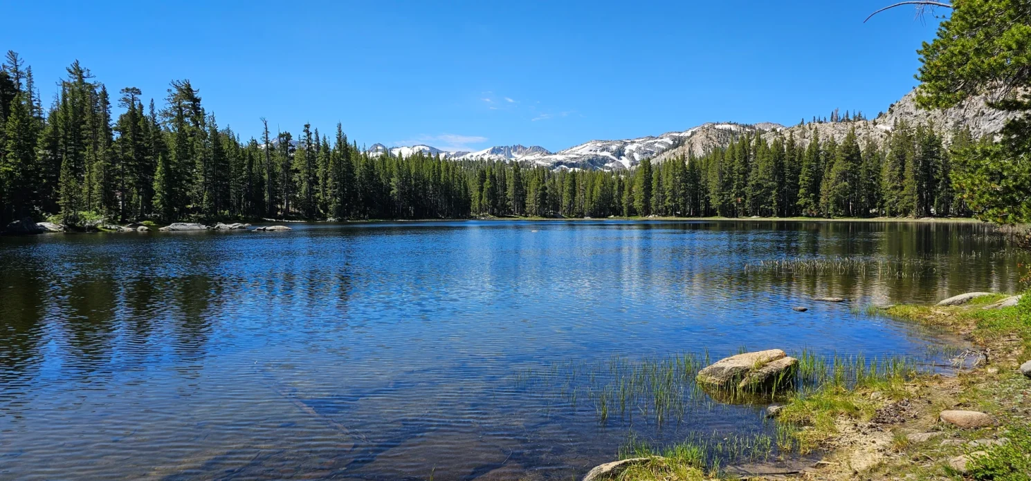
The climb from the river crossing to Freemont Lake (sitting at 8220′ elevation) is just over 500 feet, and late in the day was a bit of a butt kicker with an overpacked backpack. The views from the trail start to give you a feeling of how vast the Hoover Wilderness is and how much is hidden unless you are willing to hike in and explore. But arriving at Fremont Lake was encouraging as the lake sits in a great bowl with tall ridges & trees on three sides of the lake. According to davessierrafishing.com, there is a route up from Hidden Lake as well, but it is a stiff climb for some great fishing on the Northside of the lake.
As we made our way around the South of the lake, the abundance of forest locations for camping was encouraging, but we chose to go around the west side of the lake with our backs against the mountain. We arrived around 4 pm, and the nice breeze ran through the canyon.

Mosquito-geddon
Unfortunately, the slight breeze did nothing to protect our group from the hordes of Mosquitos we would deal with at Fremont Lake all night. This story is a common theme across the Sierra in 2023, and the late winter snowmelt has many mid-summer backpackers complaining and experiencing the same unrelenting attacks. I have seen and experienced worse, but there is no sugarcoating their effect on the experience.
A late afternoon refreshing swim brought relief while in the water, but a panicked rush back to camp to get dressed, as a shoreline was worse than camp.
With mosquito nets adorned and deet applied, we tried to enjoy a great camp dinner and an evening of stars burred out by a bright moon.
And even still with all the mosquitos, this was a good hike, and I slept like a baby in the Hoover wilderness on night one.

Chain of Lakes and Long Lakes on our way to the PCT
On day two of our trip, we would load up day packs with water and food and head out deeper into Hoover wilderness. From Fremont Lake, the PCT is about 3 miles; along the way, the trail passes by Chain of Lakes and Long Lakes. A short 200-foot climb on the South East corner of Fremont Lake carries you up to the first bench on your trail to Chain Of Lakes. The Views from this ridge are unique as they give you a peak at the borders of Yosemite and various mountains still covered in snow rising above the wilderness floor. The West Walker River basin will be running high for some time still this summer.
Chain of Lakes is about 2 miles from Freemont Lake. The first mile and a half are across a ridge line and a little bit of a climb before dropping into a valley leading you to the PCT.
Chain of Lakes is a series of small lakes that start off as a marsh with brown water and Lilly pads and culminates in a nice size fishing hole on the South. The water at this last lake looked swimmable, but it was a bit early.
Another mile and several deer later, we came to Lower Long Lake at 8500′ a charming lake that could easily be a destination for a picnic and swim. However, we pressed on another 600 yards to Upper Long Lake, found a little rock to camp out on while we had lunch, and took an afternoon swim. The views from Upper Long Lake were my favorite as two peaks abruptly expanded on the East side, making it a visually pleasing swimming and lunch spot.

The PCT and West Fork West Walker River
After lunch, a short .2 mile skip over to the PCT and first sightings of the West fork of the West Walker raging down the mountainside and under the bridge on the PCT. To our surprise, today, we met a PCT through a hiker named DoDo. She and a partner were just now coming through the Sierra, carrying their Ice axes and spikes on their packs.
The West Fork was raging and beautiful. As DoDo took off towards Sonora Pass, we could see ahead she would still deal with a little snow before hitting the pass from here.
Our group followed a trail down the river to the Walker meadow area before cutting cross country back to the Chain of Lakes area and heading back for camp. The Walker Meadow was filled with life, and we were surprised how mellow the river became just a few hundred yards below the PCT bridge as it meanders along the meadow. This area would look like a fantastic place to flyfish now, only if I knew how.
Moving Camp
As we passed Chain of lakes and headed back to camp for the day, nobody in our group was looking forward to mosquitos, and we made a rather rash decision to pick up camp and head back across the Walker River to find a Ridge camp spot along the trail for the evening. This would mean a quick pack up at 4 pm and 2 miles of hiking after a 6-mile day hike loop to the PCT. But as we entered camp, it did not take long for us to confirm our decision as the mosquitos were waiting.
Packed up and headed out, the hike down to the river seemed longer today than yesterday, and we found the crossing a little deeper and very cold/refreshing. Taking a minute for an Ice Bath plunge in the river and filling all our water bottles and bags before getting dressed and heading out to find our next camp.
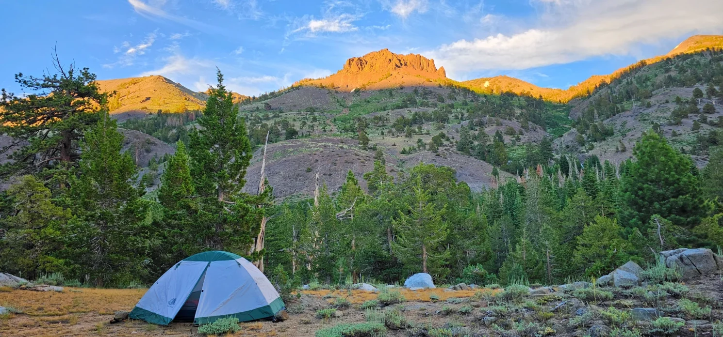
Ridgeline Camping
I have been backpacking now for six years and love backpacking into lakes. But as my oldest son can attest, there is something special about finding a ridgeline where maybe water is scarce, but the evening views and solitude are unmatched. We found a lovely location about half a mile past the Hidden Lake crossing with a ridge a hundred feet above the river canyon and a perfect 360-degree view of the Hoover Wilderness. And much to our delight, very few mosquitos.
With the sound of Waterfalls in the background, the rushing river below and a great night sky, I may have experienced my best night’s sleep in the Wilderness ever.


Trail out and Walker Burger for Food
My family and friends are all like-minded on our backpacking trips. As much as we enjoy our destinations and time in the Wilderness, on the last day, we rarely hang around long. We are often up early and hiking out before most, and it takes little time to start discussing our first meal off-trail.
For us, this 21-plus mile trip would end with a cold swim in the West Walker River, near Leavitt Meadow pack station, before shedding our packs back at the car and heading out to Walker Burger for burgers, fries and shakes. Highway 395 has three of my favorite after-hike burger stands, Mono Cone in Lee Vining, The Barn in Bridgeport and Walker Burger in Walker, California. The joke in the family is that there is a reason I am still a large hiker after all the miles I have covered in the past ten years is that I love my Cheeseburger Fries and shake after a great hike.

Overall Review of this trip
The Hoover wilderness is stunning and never disappoints. Fremont Lake was not my favorite lake I have ever backpacked into, but minus the mosquitos, I believe it would have been a very relaxing place to enjoy a hot summer weekend. The weekend’s highlight was the views of the various peaks in the Hoover wilderness and how the rivers roared with life with the 2023 snowmelt. The final night sleeping on the ridge above the river was simply a spectacular evening, and next time, I might follow the river and stay on ridgelines.
I will return, as I now better understand how easily reaching Yosemite is in the Walker River basin. The trip would need to be a 4-5 day minimum trip, but it is very reachable for a practiced backpacker. I look forward to returning, exploring the Lakes outside the Yosemite Northern border, and going to Dorthey Lake. I may hike a pack horse out of Leavitt Meadow Pack station.
Trip Total 21 plus miles – Day one 8 miles – Day 2 day trip 6 miles, Plus 2 miles hike to camp spot Day three approx. 6 miles 1450 feet of elevation gain.
