
DISCOVER THE HIDDEN ADVENTURES OF CARSON ICEBERG WILDERNESS
Explore Like a Marine!
Once the former mountain warfare training grounds of the U.S. Marine Corps, the Carson-Iceberg Wilderness as well as the Carson River draw their names from Kit Carson, one of America’s early western frontiersman. Following his initiative and boldness the first group of emigrants from the East crossed the Sierra in 1841 just north of Sonora Pass.
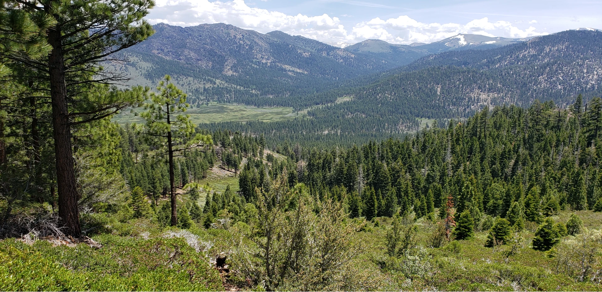
This unique and special wilderness area is a favorite of Sierra Rec Magazine, because of its quite untouched nature. Filled with deep canyons and river canyons that carve the landscape the Carson Iceberg Wilderness is an easy escape for the Carson City / Lake Tahoe region of the Sierra.
Inhabited most recently by the Miwok Indians but for over 10,000 years by other native groups, the Carson-Iceberg, has supported human life for thousands of years.
Designated wilderness in 1984 and managed today by both the Toiyabe and Stanislaus National Forests, the Carson-Iceberg includes both eastern and western slopes of the Sierra in its 161,181 acres. Though it lacks modern-day glaciers, the effect of glaciation is clear on its “Iceberg” namesake, a distinctive rock formation near Clark Fork Road on the wilderness’s southern boundary. The area is also characterized by a geologic anomaly – a series of volcanic peaks and ridges known as the Dardanelles.
Glacial carved river valleys are prevalent in the Carson Iceberg wilderness but lakes are limited. Compared to the Desolation Wilderness to the North, Carson Iceberg Wilderness is far less visited by tourist traffic and backpackers, hikers and horseman can find a quiet day in the wilderness in almost every corner.
Access to the Carson Iceberg Wilderness generally takes a little navigation on several back road connections that will end at the Wilderness boarded. Locations such as Wolf Creek or the Highland route have limited amenity Campgrounds suitable for horses at the wilderness boundaries.
Bull run Lake, Sword Lake and Heiser lake are the most common lake backpacking destinations. The headwaters of the East Fork of the Carson River, the Clark Fork of the Stanislaus, and the Mokelumne River can also be explored in the Carson Iceberg Wilderness.

Featured Carson Iceberg Wilderness Adventures
Editors Choice - Carson Iceberg Wilderness Adventure
Congress designated the Carson-Iceberg Wilderness in 1984. Most of the area still includes cattle grazing allotments, and you will likely encounter cows or their signs from July to September. The Pacific Crest National Scenic Trail runs for over 26 miles within the Carson-Iceberg. About 200 total miles of foot and horse trails give access to this outstanding wilderness, where human use is moderate, especially on the eastern side.
Carson-Iceberg Wilderness: Trail Mileages Stanislaus National Forest
Day Hiking
Recreation areas with activity Day Hiking:
- Elephant Rock Lake Trailhead
- Rock Lake Trail
- Gardner Meadow Trailhead
- Asa Lake/ Lower Gardner Meadow Trail
- Upper Gardner Meadow Trail
- Highland Creek Trailhead (at Highland Lakes)
- Highland Creek Trail (Highland Creek Trailhead)
- Mosquito Lakes Trailhead
- Emigrant/ MCCT Trail (Mosquito Lakes Trailhead)
- Heiser Lake Trail
- Mosquito Lakes to Pacific Valley/ MCCT Trail
- Mosquito Lks to PacificV/MCCT (Mosq Lks Trailhead)
- Mosquito Lks to PacificV/MCCT (PacificV Trailhead)
- Pacific Valley Trailhead
- Bull Run Creek Trail
- Silver Valley Trailhead-Carson Iceberg Wilderness
- Stanislaus Meadow Trailhead
- Bull Run Lake Trail
- Emigrant/ MCCT Trail (Stanislaus Meadow Trailhead)
- Summit Lake/ Mud Lake Trailhead
- Tryon Meadow Trailhead
- Milk Ranch Meadow Trail
- Wheats Meadow Trailhead (Spicer Dam Side)(CIW)
Backpacking
Recreation areas with activity Backpacking:
- Elephant Rock Lake Trailhead
- Rock Lake Trail
- Gardner Meadow Trailhead
- Asa Lake/ Lower Gardner Meadow Trail
- Upper Gardner Meadow Trail
- Highland Creek Trailhead (at Highland Lakes)
- Highland Creek Trail (Highland Creek Trailhead)
- Mosquito Lakes Trailhead
- Emigrant/ MCCT Trail (Mosquito Lakes Trailhead)
- Heiser Lake Trail
- Mosquito Lakes to Pacific Valley/ MCCT Trail
- Mosquito Lks to PacificV/MCCT (Mosq Lks Trailhead)
- Mosquito Lks to PacificV/MCCT (PacificV Trailhead)
- Pacific Valley Trailhead
- Bull Run Creek Trail
- Silver Valley Trailhead-Carson Iceberg Wilderness
- Stanislaus Meadow Trailhead
- Bull Run Lake Trail
- Emigrant/ MCCT Trail (Stanislaus Meadow Trailhead)
- Summit Lake/ Mud Lake Trailhead
- Tryon Meadow Trailhead
- Milk Ranch Meadow Trail
- Wheats Meadow Trailhead (Spicer Dam Side)(CIW)
Horse Riding
Recreation areas with activity Horse Riding:
- Gardner Meadow Trailhead
- Asa Lake/ Lower Gardner Meadow Trail
- Upper Gardner Meadow Trail
- Highland Creek Trailhead (at Highland Lakes)
- Highland Creek Trail (Highland Creek Trailhead)
- Mosquito Lakes Trailhead
- Emigrant/ MCCT Trail (Mosquito Lakes Trailhead)
- Mosquito Lakes to Pacific Valley/ MCCT Trail
- Mosquito Lks to PacificV/MCCT (Mosq Lks Trailhead)
- Mosquito Lks to PacificV/MCCT (PacificV Trailhead)
- Pacific Valley Trailhead
- Bull Run Creek Trail
- Stanislaus Meadow Trailhead
- Bull Run Lake Trail
- Emigrant/ MCCT Trail (Stanislaus Meadow Trailhead)
- Milk Ranch Meadow Trail
- Wheats Meadow Trailhead (Spicer Dam Side)(CIW)
Featured Trails and Elevations of the Carson Iceberg Wilderness
- Trailhead: Arnot Creek -Elevation 6240’, native surface, limited parking, fair overnight camping opportunities, no facilities.
From Summit Ranger District (Pinecrest) take Hwy 108 east 20 miles to Clark Fork Road. Turn left on Clark Fork Road and continue 6.5 miles. Trailhead is just across from the Clark Fork
Campground on left.
From Mi-Wok Ranger District (Mi Wuk
Village) take Hwy 108 east 32 miles to Clark Fork
Road. Turn left and continue 6.5 miles. Trailhead
is just across from the Clark Fork Campground on
left. - Trailhead: Clark Fork
Elevation 6400’, native surface, limited parking, fair overnight camping opportunities, no facilities. From Summit Ranger District (Pinecrest) take Hwy 108 east 20 miles to Clark Fork Road. Turn
left on Clark Fork Road and continue 10 miles to the end of the road. Trail departs from right-hand side of the road along Clark Fork Creek.
From Mi-Wok Ranger District (Mi Wuk Village) take Hwy 108 east 32 miles to Clark Fork Road. Turn left on Clark Fork Road and continue
10 miles to the end of the road. Trail departs from right-hand side of road along Clark Fork Creek - Trailhead: Corral Valley
Elevation: 8,300’ - Trailhead: Heiser Lake
Elevation: 7,950’ - Trailhead: Pacific Valley
Elevation: 7,600’ - Trailhead: Seven Pines
Elevation 6400’, native surface, limited parking, fair
overnight camping opportunities, no facilities.
From Summit Ranger District (Pinecrest) take
Hwy 108 east 26.5 miles, a mile past the Eureka
Valley Campground. Trailhead is on left. Watch for
trailhead sign. Parking just off highway.
From Mi-Wok Ranger District (Mi Wuk
Village) take Hwy 108 east 39 miles, a mile
past the Eureka Valley Campground. Trailhead is
on left. Watch for trailhead sign. Parking just off
highway. - Trailhead: Sonora Pass/
Pacific Crest Trail (North)
Elevation 9600’, improved surface, limited parking,
fair overnight camping opportunities, accessible
restrooms. Pacific Crest Trail crosses Hwy 108 at
parking area.
From Summit Ranger District (Pinecrest) take
Hwy 108 east 38½ miles. Parking area located on
left.
From Mi-Wok Ranger District (Mi Wuk
Village) take Hwy 108 east 51½ miles. Parking
area located on left.
From Bridgeport Ranger District (Bridgeport)
take Hwy 395 north 17 miles to Hwy 108. Go west
on Hwy 108 for 14 miles. Parking located on right. - Trailhead: Spicer Mdw Reservoir
Elevation: 6,400’ - Trailhead: Wheat’s Meadow
Elevation 6400’, native surface, limited parking,
fair overnight camping opportunities, no facilities.
From Summit Ranger District (Pinecrest) take
Hwy 108 east 20 miles to Clark Fork Road. Turn
left on Clark Fork Road, continue 1 mile until
crossing second bridge and turn left toward Fence
Creek Campground. Continue 4 miles and look
closely for trailhead sign on left (among trees),
about 1½ mile before County Line trailhead.
From Mi-Wok Ranger District (Mi Wuk
Village) take Hwy 108 east 32 miles to Clark Fork
Road. Turn left on Clark Fork Road, continue 1
mile until crossing second bridge and turn left toward Fence Creek Campground. Continue 4 miles
and look closely for trailhead sign on left (among
trees), about 1½ mile before County Line
trailhead.’ - Trailhead: Disaster Creek
Elevation 6400’, native surface, limited parking, fair
overnight camping opportunities, no facilities.
From Summit Ranger District (Pinecrest) take
Hwy 108 east 20 miles to Clark Fork Road. Turn
left on Clark Fork Road and continue 10 miles to
the end of the road. Trail departs from left-hand
side of road along Disaster Creek.
From Mi-Wok Ranger District (Mi Wuk
Village) take Hwy 108 east 32 miles to Clark Fork
Road. Turn left on Clark Fork Road and continue
10 miles to the end of the road. Trail departs from
left-hand side of road along Disaster Creek. - Trailhead: Ebbett’s Pass
Elevation: 8,800’ - Trailhead: Elephant Rock
Elevation: 7,100’ - Trailhead: St Mary’s Pass
Elevation 9600’, native surface, limited parking,
fair overnight camping opportunities, no facilities.
Pacific Crest Trail crosses Hwy 108 at parking
area.
From Summit Ranger District (Pinecrest) take
Hwy 108 east 37½ miles. Parking area is
located on left.
From Mi-Wok Ranger District (Mi Wuk
Village) take Hwy 108 east 50½ miles. Parking
area is located on left.
From Bridgeport Ranger District (Bridgeport)
take Hwy 395 north 17 miles to Hwy 108. Go west
on Hwy 108 for 14 miles.
Parking located on right. - Trailhead: County Line
Elevation 7200’, native surface, limited parking,
fair overnight camping opportunities, no facilities.
From Summit Ranger District (Pinecrest) take
Hwy 108 east 20 miles to Clark Fork Road. Turn
left on Clark Fork Road, continue 1 mile until
crossing second bridge and turn left toward Fence
Creek Campground. Continue 5.5 miles to the end
of the road.
From Mi-Wok Ranger District (Mi Wuk
Village) take Hwy 108 east 32 miles to Clark
Fork Road. Turn left on Clark Fork Road, continue
1 mile until crossing second bridge and turn left
toward Fence Creek Campground
| Trailhead | Elevation | Destination | Miles |
|---|---|---|---|
| Arnot Creek | 6,350' | Arnot Creek/Woods Gulch Jct. | 2.0 |
| Woods Gulch | 4.0 | ||
| Jenkins Canyon | 6.0 | ||
| Disaster Creek Trail | 6.5 | ||
| Highland Creek | 8.0 | ||
| Upper Gardner Meadow | 8.0 | ||
| Hiram Meadow | 10.0 | ||
| Sword Lake | 12.0 | ||
| Highland Lake | 12.5 | ||
| Lost Lake | 12.5 | ||
| County Line TH | 14.0 | ||
| Lake Alpine | 18.0 |
| Trailhead | Elevation | Destination | Miles |
|---|---|---|---|
| Corral Valley | 8,300' | Coyote Valley TH | 1.0 |
| Poison Flat | 4.2 | ||
| Coyote Valley | 4.3 | ||
| Connel’s Cow Camp | 5.8 | ||
| Soda Spring | 6.2 | ||
| Poison Lake | 6.7 | ||
| Carson River | 8.2 | ||
| Falls Meadow | 8.2 | ||
| Silver Creek Meadow | 9.3 | ||
| Murray Canyon | 10.2 | ||
| PCT Trail | 11.2 | ||
| Ebbett’s Pass | 22.7 | ||
| Sonora Pass | 25.2 |
| Trailhead | Elevation | Destination | Miles |
|---|---|---|---|
| Seven Pines | 6,200' | Clark Fork/St Mary’s | 7.0 |
| Boulder Creek | 9.0 | ||
| Clark Fork Meadow | 9.5 | ||
| Boulder Lake | 10.8 | ||
| Clark Fork TH | 11.5 | ||
| St Mary’s TH | 12.0 |
| Trailhead | Elevation | Destination | Miles |
|---|---|---|---|
| Wheat’s Meadow | 6,500' | Dardanelle Creek | 1.5 |
| Wheat’s Cow Camp | 3.0 | ||
| Burgson Lake | 3.1 | ||
| Sword Lake | 4.5 | ||
| Lost Lake | 5.0 | ||
| Bummer’s Flat TH | 6.0 | ||
| County Line TH | 6.5 | ||
| Spicer Mdw Reservoir | 6.5 | ||
| Highland Creek | 8.5 |
| Trailhead | Elevation | Destination | Miles |
|---|---|---|---|
| Disaster Creek | 6,400' | Adams Camp | 2.5 |
| Adams Camp PCT | 3.5 | ||
| Golden Canyon | 3.5 | ||
| Upper Gardner Mdw | 6.5 | ||
| Carson Falls | 7.5 | ||
| Murry Canyon | 8.5 | ||
| Falls Meadow | 9.0 |
| Trailhead | Elevation | Destination | Miles |
|---|---|---|---|
| Elephant Rock | 7,100' | Rock Lake | 2.0 |
| Silver Valley TH | 3.0 | ||
| Duck Lake | 4.0 | ||
| Summit Lake TH | 5.0 | ||
| Rock Lk Trl to Duck L | 5.5 | ||
| Highland Creek | 8.5 | ||
| Bull Run Peak | 10.5 |
| Trailhead | Elevation | Destination | Miles |
|---|---|---|---|
| County Line | 7,200' | Sword Lake | 2.0 |
| Lost Lake | 2.5 | ||
| Highland Creek | 6.0 | ||
| Wheats Mdw TH | 6.5 | ||
| Hiram Meadow | 8.0 | ||
| Highland Lake | 12.5 |
| Trailhead | Elevation | Destination | Miles |
|---|---|---|---|
| Clark Fork | 6,400' | Boulder Creek | 2.5 |
| Boulder Lake | 4.2 | ||
| Seven Pines Trail | 4.5 | ||
| Clark Fork Meadow | 7.0 | ||
| St Mary’s Pass TH Jc | 9.5 | ||
| St Mary’s Pass | 10.0 |
| Trailhead | Elevation | Destination | Miles |
|---|---|---|---|
| Heiser Lake | 7,950' | Heiser Lake | 1.5 |
| Bull Run Lake | 3.6 | ||
| Stanislaus Mdw TH | 5.0 |
| Trailhead | Elevation | Destination | Miles |
|---|---|---|---|
| Pacific Valley | 7,600' | Bull Run Peak | 3.0 |
| Highland Creek | 6.5 | ||
| Hiram Meadow | 7.0 | ||
| Tryon Meadow | 8.0 | ||
| Jenkins Canyon | 8.5 | ||
| Sword Lake | 10.5 | ||
| Lost Lake | 11.0 | ||
| County Line TH | 12.5 |
| Trailhead | Elevation | Destination | Miles |
|---|---|---|---|
| Sonora Pass/Pacific Crest Trail (North) | 9,600' | Wolf Creek | 3.0 |
| White Canyon | 9.0 | ||
| Carson Falls | 10.5 | ||
| Golden Canyon | 11.5 | ||
| Asa Lake | 17.0 | ||
| Noble Lake | 17.6 | ||
| Noble Creek | 21.6 | ||
| Ebbett’s Pass | 24.5 |
| Trailhead | Elevation | Destination | Miles |
|---|---|---|---|
| Spicer Mdw Reservoir | 6,400' | Wheat’s Cow Camp | 3.5 |
| Dardanelle Creek | 5.0 | ||
| Bummer’s Flat | 6.5 | ||
| Wheat’s Mdw TH | 6.5 | ||
| Sword Lake | 8.5 | ||
| Lost Lake | 8.5 | ||
| County Line TH | 10.0 | ||
| Highland Creek | 12.0 | ||
| Hiram Meadow | 14.0 | Highland Lake | 18.5 |
| Trailhead | Elevation | Destination | Miles |
|---|---|---|---|
| Ebbett’s Pass | 8,800' | PCT/Noble Lake | 4.0 |
| Bull Lake Trail | 4.5 | ||
| Bull Lake | 8.0 | ||
| Asa Lake | 6.5 | ||
| Murray Canyon | 10.5 | ||
| Golden Lake | 12.0 | ||
| White Canyon | 15.5 | ||
| Adams Camp | 15.6 | ||
| Carson Falls | 16.1 | ||
| Wolf Creek Mdw | 16.5 | ||
| Disaster Creek TH | 18.1 | ||
| Wolf Creek | 21.5 | ||
| Sonora Pass TH | 24.5 |
| Trailhead | Elevation | Destination | Miles |
|---|---|---|---|
| St Mary’s Pass | 9,550' | Clark Fork Meadow | 2.5 |
| Stanislaus Peak | 3.0 | ||
| Seven Pines Trail Jct. | 5.0 | ||
| Boulder Creek | 7.0 | ||
| Boulder Lake | 8.8 | ||
| Clark Fork TH | 9.5 | ||
| Seven Pines TH | 12.0 |