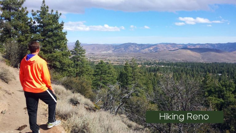
Hiking Trails in Reno, NV
If you’re looking for a quick and easy hike near Reno, NV, there are plenty of options to choose from. The Oxbow Nature Study Area Trail, located off Dickerson Road, is a great choice for beginners or families with young children. For a slightly longer hike, check out the Tom Cooke Trail in west Reno, which is part of the city’s urban trail system. Both trails offer a chance to get outside and enjoy the beautiful scenery of Northern Nevada.
Reno has a complete network of Urban Trails to choose from:
View Reno’s Urban Trails in a larger map
-
- Oxbow Nature Study Area Trail
-
- Tom Cooke Trail

Tom Cook Trail
If you’re looking for a quick and easy way to enjoy nature near Reno, the Tom Cooke Trail is a great option. This trail is located right next to the Truckee River and is open to hikers, mountain bikers, horseback riders, and trail runners. It’s a short hike, only about 1.2 miles roundtrip, but it offers beautiful views and a chance to escape the city. Just remember that motorized vehicles are not allowed and if you bring your furry friend, make sure they’re on a leash.
For a bit of variety, try accessing the side loop trail by ascending at the trailhead. While the trail is short, it offers a challenging climb up a set of switchbacks right after crossing the Truckee River footbridge. The climb is worth it, as you’ll be rewarded with stunning views of the Nevada landscape from a couple hundred feet up.
Oxbow Nature Study Area
Looking for a peaceful hike near Reno? Look no further than the Oxbow Nature Study Area! This hidden gem is just a short distance from downtown Reno, but it feels like a world away. The one-mile nature trail takes you through a variety of landscapes, including cottonwoods, willows, and grasslands, and offers stunning views of the Truckee River. Keep your eyes peeled for wildlife, as there are plenty of opportunities to spot animals throughout the 22-acre Study Area. Whether you’re a seasoned hiker or just looking for a leisurely stroll, Oxbow Nature Study Area is a must-visit destination for nature lovers in Northern Nevada.
Some popular trails in the Truckee Meadows area include the Huffaker Park Loop Trail, the Mira Loma Urban Trail, Whites Creek Trail, and Galena Creek Trail. Each of these hikes offers unique scenery and varying levels of difficulty, so be sure to do your research and choose the one that’s right for you.
The Huffaker Park Lookout Trail is a great option for scenic hiking. Located in south Reno, this trail offers stunning views of the city skyline and is approximately 1.7 miles long. It’s suitable for both walking and trail running, and if you’re short on time, there’s a shorter option available from the same trailhead.
Mira Loma Urban Trail. If you are seeking public park hiking system in Reno check out the Mira Loma Urban trail system. This trail offers a variety of amenities, including fitness courses, sports fields, a playground, picnic areas, and restrooms. But the real highlight of the trail is the area’s largest skatepark, which features several bowls, halfpipes, rails, and fun boxes for skateboarders, roller skaters, and BMX riders to enjoy. For a scenic hike, follow the water’s edge along the northeastern part of the loop where Boynton Slough meets Mira Loma Park, and you’ll hit the trailhead.
Rancho San Rafael Regional Park. With miles of trails winding through wetlands and natural desert landscapes, as well as the stunning May Arboretum, this park offers a peaceful escape from the city just minutes away. For a more challenging hike, head to the ‘N’ on the hill north of McCarran Blvd. Accessible by foot or bike via a tunnel in the park, the hike to the N offers breathtaking panoramic views of Reno and Sparks, surrounded by the Virginia Foothills and Sierra Nevada mountains. Don’t miss out on this must-see hiking destination in Northern Nevada.
Galena Creek Trail
Galena Creek Trail is a popular creek hike near Reno. These trails, with 4.8 miles of trails, are mostly hiker friendly, biking, or running. It is comparatively moderate in its height of 776 m. For beginners, however, the short duration and maintained path will be easy. The trail runs along Galena Creek in the community and on golf courses although the area offers some great wilderness to explore. Many hikers describe it as quiet with the river flowing all around. Obviously if you like a pristine golf course, it’s the ideal choice. A well designed easy-going trail is also a good choice for beginners, solo hikers and runners.
Keystone Canyon Loop (East)
Keystone Canyon Loop is a 4.9 miles hiking trail near Reno that mostly consists of hiking, nature tours or mountain biking. These trails are classified as moderate and have a height of 603 feet. The lack of shade or rock makes the trip harder than it first appears. This trail includes keys to Keystone Canyon Rabbitman Blast and Podunk Trails in an integrated loop. It also offers many other trails that span the desert-like terrain to ensure easy adjustments on the length of the hike. The problem of this place is that lack of sunlight creates additional difficulties during hot days. Besides sunscreen, water is strongly recommended.
Ophir Creek Loop from Tahoe Meadows
Ophir Creek Loop from Tahoe Meadow is a 3.2 miles loop close to Incline Village which mainly serves hiking trips. It can be easily navigated with only 262 feet of elevation. This place is also very friendly both to children and dogs and is perfect for families. The trail follows Ophir Creek through gorgeous Tahoe Meadow and then loops around Ophir Creek Trail to its end. It’s a fantastic hike that reconnects you with nature and relaxes, but there’s no ‘Wow’ aspect to be noted here. But it is a nicely maintained hike which features river, pasture and wildlife. 9 Sturtural Recreation Lake Near Las Vegas Nevada.
Brown’s Creek Loop Trail
Brown Creek Loop is a 4 miles loop trail in Washoe Valley. It is largely used for dog walking, mountain biking or walking. Its elevation gain of 997 feet and steep paths contribute to its moderateness. The route runs along Brown River and crosses two crosswalk points over bridges that provide views of the beautiful bluewater below. This place is busy so come early if beating people will help. There are many shaded places, including a couple of exposed ones, and inclines, decline and flat spots are evenly distributed, making it a comfortable trip. The Best Lakes in Nevada.
Diamond Peak from Tahoe Meadows
Diamond Peak near Tahoe Meadow is a 16.1 mile trail near Washoe Valley that is ideal for walking, hiking and snowshoeing during the winter months. The trail is moderate and is 1.773 ft long. Its length increases its challenges. Starting in Tahoe Meadows, this path leads toward Diamond Peak which offers breathtaking views of Lake Tahoe. A beautiful forest of pine trees can also be enjoyed on the trail. There are no complaints regarding this route, but some report of bear sightings further down on this trail.
Peavine Peak Trail
Peavine Peak Trail is a 9.9-mile trail from Reno to Reno that is used mostly for hiking, dog walks or nature trips. It is considered a difficult trail with an elevation of 2800 feet to Peavine Peak. It is 8216 feet high. It’s a difficult but rewarding hiking trip with fantastic views of Reno on a clear day. Nevertheless, the views don’t have panoramic qualities because the mountains nearby have more than just a small South Mountain (802ft) The climb is difficult but it’s a must for anyone who has slipped down a mountain. 12 beautiful recreation lakes near Reno, NV.
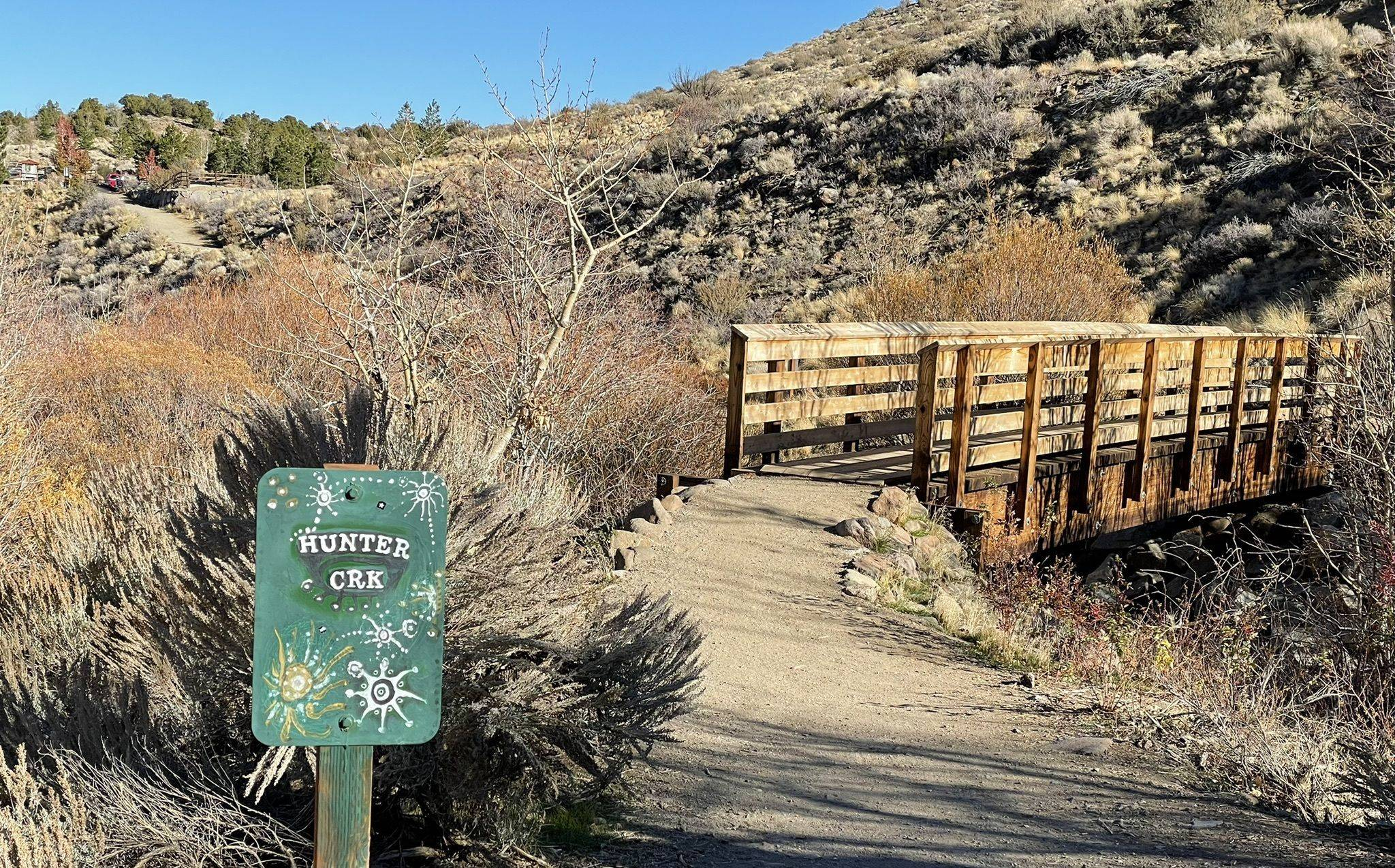
Northern Nevada offers a plethora of hiking options for outdoor enthusiasts. For those seeking a challenge, Hunter Creek Trail and Upper Thomas Creek Trail are both great options with stunning views of streams and waterfalls. Hunter Creek Trail rewards hikers with a magnificent flowing waterfall after completing the 5.7-mile hike, while Upper Thomas Creek offers a refreshing splash in a dazzling flowing creek before looping back around.
Lake Tahoe also offers a variety of hiking trails, including the Rubicon Trail that hits two different state parks. For those looking for a greater challenge, check out our guide to backpacking the Sierras. Camping spots near Reno provide quick access to hiking trails, and for winter activities, try snowmobiling or other famous Lake Tahoe winter activities. Don’t forget to share your hiking pictures on social media using the hashtag #RenoTahoe for a chance to be featured on the site and inspire other hikers to hit the trails.
Hiking in Reno & Lake Tahoe: Northern Nevada Adventures
If you’re looking for some great hiking spots near Reno, Nevada, you’re in luck! With a variety of trails to choose from, you can explore the beautiful outdoors all year round. Some popular options include the Hunter Creek Trail and Galena Creek Trail, both of which offer stunning views and a moderate level of difficulty. For those seeking a more challenging adventure, the Mount Rose Wilderness Area is a must-visit destination located between Reno and North Lake Tahoe. No matter which trail you choose, be sure to bring plenty of water and sunscreen, and always practice Leave No Trace principles to help preserve the natural beauty of the area.
Northern Nevada offers plenty of great hiking spots near Reno! Here are some of the best ones to get you started:
If you’re looking for a scenic hike near Reno, the Mount Rose Wilderness Area is a must-visit destination. This area, named after the highest peak in the Carson Range, offers stunning views of Lake Tahoe and the surrounding desert landscape. Along the way, hikers can enjoy the sight of beautiful waterfalls and vibrant wildflowers during the summer months. And of course, the highlight of any hike in this area is reaching the summit of Mount Rose, which stands at an impressive 10,766 feet.
If you’re looking for some outdoor adventure near Reno, Northern Nevada has plenty of hiking options to choose from. One of the most popular trails is the Lake Tahoe Rim Trail, which offers a 165-mile loop around the lake with stunning alpine views and opportunities to climb some of the area’s highest peaks. But if you’re short on time or just looking for a leisurely stroll, there are plenty of shorter sections of the trail that offer beautiful meadow walks and scenic vistas. Lace up your hiking boots and get ready to explore the natural beauty of Northern Nevada!
If you’re looking for some great hiking spots near Reno, Northern Nevada has plenty to offer. One must-visit destination is Lake Tahoe, where you can find some of the tallest and most well-known mountains in the area, including Mt. Tallac, Jobs Peak, and Freel Peak. For a more challenging hike, head to the Desolation Wilderness, where you can explore jagged summits and numerous backcountry lakes. This area is also home to a portion of the Pacific Crest Trail and the Tahoe Rim Trail, making it a popular spot for thru-hikers.
Looking for some great hiking spots near Reno, Nevada? Look no further than Mount Rose Summit! This beautiful mountain offers a variety of trails for hikers of all skill levels, with stunning views of the surrounding landscape. Whether you’re looking for a leisurely stroll or a challenging climb, Mount Rose Summit has something for everyone. So grab your hiking boots and hit the trails for an unforgettable adventure in Northern Nevada!
Looking for some great hiking spots near Reno? Northern Nevada has plenty of options for outdoor enthusiasts. Some popular trails include the Hunter Creek Trail, Mount Rose Trail, and the Tahoe Rim Trail. Make sure to bring plenty of water, sunscreen, and appropriate footwear. And don’t forget to check the weather forecast before heading out!
If you’re looking for a hiking adventure in Northern Nevada near Reno, the Toiyabe Crest Trail is a must-visit destination. This 75-mile trail offers a remote wilderness experience where you can enjoy stunning views and have the trail all to yourself. The trail follows the top of the timberline and crosses the breathtaking Toiyabe Range, providing access to towering peaks like Bunker Hill (11,477′) and Arc Dome (11,781′) with views that stretch for 100 miles. Thru-hikers, take note!
The New Virginia Truckee trailway to Carson City
A new addition for multi-use trail networks is available from the Truckee River in Reno to South Carson City. Hikers, Bikers, E-bike all can enjoy this multiuse route that follows for a large part of the trail the old Virginia Truckee railway. Part of a new trail system in the Rails to Trails Conservancy. The trail markers are up in town and can be followed through the Washoe Valley and into Carson city. the eventual dream of this trail is to make it across the Carson river and down into Gardnerville NV where the train used to stop south of Reno.
The developing Historic Virginia & Truckee Trail inhabits one of the most famous railroads in Nevada History. The corridor dates back to 1868, when the Virginia and Truckee Railroad was built by the Bank of California to carry ore from the Comstock silver mines of Virginia City to the processing mills along the Carson River.
The rail corridor’s new life as the Historic Virginia and Truckee Trail will connect five counties, five cities and six museums. Bicyclists ride along much of the old route, without even realizing it, through Washoe and Pleasant Valleys in Washoe County.
Once complete, the rail-trail will also link together a handful of regionally and nationally significant trails such as the 1,800-mile Pony Express Trail and the 114-mile Tahoe Pyramid Trail. Through connections to those trails and others in Carson City and Douglas and Washoe counties, travelers can also reach the Tahoe Rim Trail and the Pacific Crest Trail.
MT Rose Wilderness
The Mount Rose Wilderness is an area of federally protected land in the US state of Nevada. It encompasses about 43.75 square miles (113.3 sq. km) of land and contains ten named peaks, the highest and most prominent of which is Mount Rose (10,778ft/3,285m).
Mount Rose Summit
If you’re interested in hiking to the top of the highest summit in the Mount Rose Wilderness, then this trail is for you. The Mount Rose Summit Trail starts at a parking lot off of the Mount Rose Highway.
It starts off fairly mellow until you cross Galena Creek and start your ascent. Soon, the 12-mile (19.3km) roundtrip trail makes switchbacks all the way to the summit, where you get views of the scenic Tahoe Basin.
Whites & Thomas Creek Canyons
These two canyons are easily accessible via the Dry Pond Trail. The trail provides 8 miles (12.9km) of hiking that offers good views of the Washoe Valley and of Mount Rose. Additionally, the region is blanketed with wildflowers in the spring and summer months, so it’s an excellent place to wander during an adventure to the Mount Rose Wilderness.

Speaking of Connecting Communities and great trail networks close to Reno. Head south into Carson City for a great rail network that includes bike and hike routes up to the Tahoe Rim trail, as well as Waterfall and creek hikes.
The most popular trail system in Carson City is the Ash to Kings Canyon trail network. This trail region set into the base of the Carson range on the West side of Carson city features waterfalls, creeks, short easy hikes and longer more advanced climb trails that will take you all the way up to the Tahoe Rim trail.
For a complete guide to Carson City check out their website and learn about the eight primary regions of trail networks they support:
Ash Canyon –The Ash Canyon Trail Network weaves its way through the tranquil Ash Canyon, where a tapestry of diverse ecosystems unfolds before your eyes. Here, you can explore a variety of trails that cater to hikers, mountain bikers, and equestrians, ensuring there’s something for everyone to enjoy. The network’s well-maintained paths wind through dense forests, meadows adorned with wildflowers, and rugged canyons, all while providing stunning views of the Carson City region and the Sierra Nevada mountains. As you venture deeper into Ash Canyon, the soothing sound of rustling leaves and the chirping of birds accompany you on your journey. With trails suitable for both beginners and experienced outdoor enthusiasts, the Ash Canyon Trail Network allows visitors to choose their own adventure. Whether you’re seeking a leisurely stroll through nature, a challenging mountain biking excursion, or a peaceful horseback ride, Ash Canyon’s diverse trail offerings never disappoint.
-
-
Ash to Kings Trail – the feature trail in the canyon is A seven-mile single-track, non-motorized trail linking Ash Canyon Road on the north end and Kings Canyon Road on the south end.
-
Ash Canyon Road– Ash Canyon Road provides the only motorized access into the Carson Range in the Ash Canyon area. Motorized access ends after 4.5 miles at the State Park boundary where there is a small parking area and a half-mile walk to Hobart Reservoir.
- The remaining Trail segments in the Ash Canyon Network include Bob’s Trail, seven Steps Trail, Potash Trail, Eagle View Trail, Vicee Trail, four Day Trail, creek trail and Evidence trail a network of short and varied difficulty trails connecting in a web of great adventure.
-
Kings Canyon – The Kings Canyon Trail System presents a diverse array of trails catering to hikers, mountain bikers, and equestrians, ensuring there’s an adventure for every nature enthusiast. These well-maintained paths lead you through a landscape that transitions from dense woodlands to open meadows, providing breathtaking vistas of the Carson City area and the iconic Sierra Nevada mountains.
As you traverse the trails within Kings Canyon, the soothing sounds of flowing water and the gentle whisper of the wind through the trees create a serene backdrop for your outdoor journey. The network offers a range of trail difficulties, accommodating both beginners and seasoned outdoor adventurers. Whether you’re seeking a leisurely hike, an exhilarating mountain biking experience, or a peaceful horseback ride, the Kings Canyon Trail System delivers on all fronts. Trai include:
-
- Ash To Kings – covered in above description
- Upper Waterfall Loop – Take the road less traveled to the Upper Waterfall at Kings Canyon! This trail has unforgettable views of the old Borda Ranch Meadows and overlooks all of Carson City. If you’re looking for a more intense time recreating, connect at mile 1.5 to the south end of the Ash-to-Kings Trail.
- Waterfall Trail – Built in 2010 by Boy Scouts of America Troop 341, get out and experience a gem of Carson City- the Kings Canyon Waterfall! This hike is short and sweet with a rewarding end. Dogs are no longer permitted at this trail due to an increased priority in protecting Carson City’s drinking water. Dogs are allowed at many other trails around Carson City and we ask that you continue to recreate to help protect our parks and open spaces responsibly!
- North Kings Loop – 1.8 mile – The North Kings Loop provides amazing views of the old Borda Ranch Meadows with tons of wildflowers in the late spring and early summer months. Allows connection to the Upper Waterfall Trail.
- Lincoln Bypass Trail – Named Lincoln Bypass as it “bypasses” Kings Canyon Road, which is part of the historic Lincoln Highway. This trail was built by Muscle Powered at the start 2021 offering beautiful views of the Borda Meadow.
- Kings Canyon Road – Historic Kings Canyon Road was once a toll road to Lake Tahoe and later part of the Lincoln Highway. Even earlier in Carson City’s history, this road was a route used by the Washoe Tribe. This road can be used to make a loop with the Ash-to-Kings Trail. Sections of this road have sustained heavy flood damage with recent improvements made in 2022.
-
NEW Capital to Tahoe Trail- A 17-mile route that starts in downtown Carson City will climb from the Ash to Kings trail up to the Tahoe Rim trail intersection above Marlette Lake. From there, riders can connect with road networks into Spooner State Park or navigate down to the Flume trail into North Lake Tahoe. Start at Lincoln Bypass Trail off Kings Canyon Road. The Lincoln bypass trail is a newer section of trail completed in 2021 by Sierra Trail Works & Muscle Powered. It provides riders a mellower route and will connect riders to the Kings to Ash Canyon trail and then to the Capitol to Tahoe Trail, leading travelers to Laxal Flat above Marlette Lake between Hobart Lake and Marlette Lake. Travelers can then travel down the Marlette Lake Road into Spooner State Park or turn North at the Lake to connect with the Flume Trail or the Marlette Creek Trail.
-
-
River Park View Trail Network – over 13 miles of local trails Located at the very east-end of Fifth Street, Riverview Park is a 109 acre natural scenic park, with wetlands and a network of trails which extend to the banks of the Carson River and connect with the Mexican Ditch and Empire Ranch Trails. Many paved trails traverse the area, including a 1.6 mile course and an additional 0.4 mile nature trail, making this a perfect venue for Walk/Run Events. Dogs are allowed off leash during all park hours but are not allowed in the wetland areas and must be under adequate control of their owners at all times.
-
-
-
C-Hill – C-Hill is a popular summit just northwest of downtown Carson City, Nevada. Characterized by the “C” representing Carson City located on its east-facing slope. C-Hill does a good job elevating you above the capital city of Nevada. While not high by any means, C-Hill is surprisingly scenic. It offers a pleasant desert landscape, with views to the Sierra Nevada Mountains directly to the West, and views to the desert peaks of the east. In addition, there are opportunities for scrambling due to the number of boulders at the summit. There is no shade on this hike so bring ample water. Hikers can find trail heads off Curry Street just south of downtown or off of King St. This 1.90 mile, out and back trail, generally considered a moderately challenging route, it takes an average of 1 h 22 min to complete. This is a popular trail for hiking, horseback riding, and other nature trips, but you can still enjoy some solitude during quieter times of day. The trail is open year-round, but the best times to visit are March through September. Dogs are welcome and may be off-leash in some areas.
-
Prison Hill –The Prison Hill Recreation Area, spanning approximately 2,500 acres, stands as a testament to Carson City’s commitment to preserving open spaces for its community. Nestled on the southeast side of town, this natural haven offers a diverse range of outdoor experiences that cater to hikers, mountain bikers, equestrians, and even off-highway vehicle enthusiasts on its southern end. The area provides a picturesque backdrop for visitors seeking stunning views of the Carson Range, Pine Nut Mountains, and the Carson River, making it a photographer’s paradise. Prison Hill boasts three main community parking areas, including the newly established 5th Street Trailhead, which now connects seamlessly to the Carson River Trail System. The northern section of Prison Hill, accessed via East 5th Street and Carson River Road, features non-motorized trails that wind through captivating landscapes. These trails are perfect for those on foot, bicycle, or horseback, offering a peaceful escape from city life while providing panoramic vistas of Carson City’s natural beauty.
-
Located within the picturesque landscape of Carson Valley, the Carson Valley Trail Network offers an enchanting gateway to the region’s natural beauty. As the network continues to expand, outdoor enthusiasts and nature lovers alike have the opportunity to embark on a journey through some of Nevada’s most stunning and diverse terrains. Whether you’re seeking a tranquil stroll along the serene meadows of the Valley Floor or an adrenaline-pumping mountain biking adventure in the Sierra Nevada foothills, the Carson Valley Trail Network promises an array of experiences for all. With each new trail that is added, the network unveils even more scenic treasures waiting to be discovered, making it a must-visit destination for those who crave the serenity and wonder of the great outdoors.
Caron Valley Trail Networks

-
Genoa Trail System –
Tucked away in the charming town of Genoa, the Genoa Trail System offers over 17 miles of outdoor bliss, welcoming hikers, equestrians, mountain bikers, and even our four-legged friends. With picturesque trails like the Sierra Canyon Trail, Genoa Loop, and Eagle Ridge Loop, this trail network promises unforgettable adventures for all who visit.
Discovering the Genoa Trails
The Genoa Trail System is a versatile playground for outdoor enthusiasts, but it’s essential to know the lay of the land. The trail comprises two loops, with the lower sections meandering along public roads in and around the historic town of Genoa. A longer 10-mile loop connects the Eagle Ridge and Genoa Canyon Trailheads, utilizing a mix of trails and roads that wind their way through Genoa’s scenic beauty.
-
The Epic Sierra Canyon Trail
For those seeking an epic adventure, the Sierra Canyon Trail awaits. Stretching a formidable 10 miles one way, this trail boasts substantial elevation changes, making it a challenging yet rewarding hike. As you venture deeper into the Sierra Canyon Trail, prepare for breathtaking vistas and the promise of Lake Tahoe views that will leave you in awe. For the ultimate experience, continue another mile north to the Tahoe Rim Trail, where you’ll find the best vantage point to admire the majestic Lake Tahoe. If you plan to make it a round-trip hike, be ready to dedicate a full day to the journey. Alternatively, consider shuttle options by starting or ending your adventure at the Kingsbury North Trailhead or Spooner Summit Trailhead along the Tahoe Rim Trail.

-
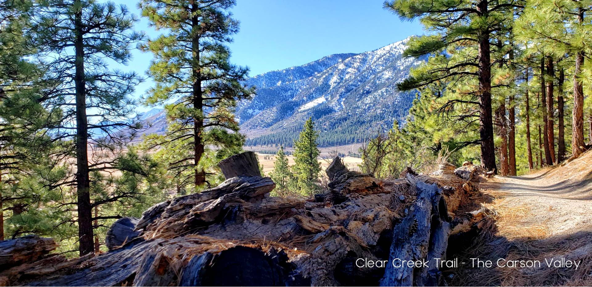
Clear Creek Trail Network –
The Clear Creek Trail System, a sprawling 30-mile network of adventure, beckons outdoor enthusiasts of all kinds. Open to hikers, mountain bikers, equestrians, and our four-legged companions, this trail system offers a rich tapestry of landscapes to explore. The Clear Creek Trail itself spans approximately 22 miles, with its highest point beginning at the Spooner Summit Trailhead on the south side of Highway 50 and its lowest section starting at the James Lee Park Trailhead. For a shorter yet equally rewarding journey, consider the Clear Creek Connector, a 2-mile access point from the Clear Creek Connector Trailhead. The Jacks Valley Road Trailhead, Jacks Valley School Trailhead, and James Lee Park Trailhead grant direct access to various loops, such as the James Lee Loops and Jacks Valley Loop, ranging from 2 to 12 miles in length. While the trail system boasts diverse elevations and breathtaking scenery, it’s essential to plan your visit wisely. Spring and fall offer the most favorable conditions, while summer can be scorching, especially on the lower half of the trail. Winter brings snow that limits access to the middle and upper portions, usually clearing up by mid-April in lower areas and early June around Spooner Summit.
Landscape and Scenic Highlights
As you traverse the Clear Creek Trail System, you’ll journey through a captivating blend of chaparral and wooded landscapes. The lower half features sagebrush, rabbitbrush, and bitterbrush, while the upper half introduces you to a wooded wonderland of Jeffrey Pine, white fir, incense cedar, sugar pine, aspen, and willow. Panoramic vistas grace the lower half, with must-see viewpoints like Knob Point and Cliff Rock punctuating the upper portion. Shade is scarce on the lower trails, primarily provided by tall brush, making spring and fall visits even more appealing for a comfortable outdoor experience. Whether you’re seeking challenging hikes, exhilarating mountain biking trails, or equestrian adventures, the Clear Creek Trail System has something for every nature enthusiast.
-
Fay Luther Trail System –
The Fay-Luther and Jobs Peak Ranch Trail System, nestled in the heart of natural beauty, offers a peaceful retreat for outdoor enthusiasts. Linking the Fay-Luther and Jobs Peak Ranch Trailheads through a 3.5-mile connection, this network extends approximately 9 miles of loop and connector trails, welcoming hikers, bikers, equestrians, and their furry companions. While the Interpretive Loop unveils the area’s natural wonders with informative signs, it’s important to remember that access to Jobs Peak is limited, so please adhere to designated trails and respect private property boundaries.
For those on two wheels or four hooves, most trails are open to mountain biking and equestrian activities. However, the section of the Fay-Luther/Jobs Peak Ranch Trail between the Jobs Peak Ranch Trailhead and the Valley View Loop is exclusive to hikers due to its challenging terrain and private land restrictions. While biking may be challenging on some trails due to sandy, loose soils, the network offers ample opportunities for equine exploration, with horse trailer parking available at the Fay-Luther Trailhead. Dogs are welcome but must be leashed year-round on the first 1.5 miles from the Jobs Peak Ranch Trailhead and from November 15 to March 30 elsewhere to protect the area’s wildlife. The trail system’s diverse landscapes, ranging from sagebrush-covered stretches to open Jeffrey pine forests, promise scenic views of the Carson Range, Pine Nut Range, and Carson Valley. To embark on your adventure, follow Highway 88 south from the intersection of Highway 395 and Highway 88 in Minden or from the base of Kingsbury Grade, and savor the serenity of Fay-Luther and Jobs Peak Ranch’s captivating trails.
-
Pinyon Trail – The Pinyon Trail is a 5-mile round-trip hike located about 7 miles east of Gardnerville. This trail is open to hikers, equestrians, mountain bikers and dogs. This trail project was funded and built by the Carson Valley Trails Association in partnership with the Bureau of Land Management and Douglas County.
-
Bently Heritage – Explore nearly one mile of hiking trail to the Carson River in the Carson Valley. The trail was constructed through a partnership between the Carson Valley Trails Association, The Nature Conservancy, local Eagle Scouts and the property owner.
Here, the Carson River winds its way in braided channels supporting willows and wetlands that sustain many animals and migratory birds. The trail provides visitors with access to this natural area with amazing panoramic views. -
River Fork Ranch –
The River Fork Ranch Trail System is one mile east of Genoa on Genoa Lane at the confluence of the East and West Fork of the Carson River. The property is owned by The Nature Conservancy. The trail system is shown on the Genoa Trail System map. More information about River Fork Ranch can be found on the Nature Conservancy website.
There are two trails at River Fork Ranch, the 0.75 mile East Brockliss Loop and the 2.0 mile West Fork Trail. Both trails are flat. There are two narrow boardwalks on the East Brockliss Loop. The West Fork Trail parallels the West Fork Carson River, connecting Genoa Lane to Muller Lane with panoramic views. Except during wet periods, this trail is relatively easy to access by wheelchair users as it follows a dirt ranch road. There are also interpretive signs at the ranch house about the area.
