This long-weekend route combines an early morning in Yosemite Valley, swimming at Tenaya Lake, hiking near Pinecrest, exploring the Red Hills and a scenic drive over Sonora Pass.
Tuolumne County is one of those Sierra regions that can be difficult to explain in a single sentence. It acks as a base camp region in the Western Sierra using Hwy 49 and , 120 and 108 as travel spokes that plug travelers deep into adventure rich landscapes with a tone of variety.
Yosemite National Park may be the name that gets most travelers onto Highway 120, but it is only one piece of this regions unique experience. The same trip can include historic downtowns and a great breakfast in Sonora, an afternoon swim beneath a waterfall, a quiet evening at New Melones Lake, Tasty pizza or burgers in Groveland and a drive over one of the most dramatic mountain passes in California.
I made a version of this trip several years ago from Carson Valley. We left after work on a Thursday night, crossed the Sierra on Highway 88 and connected with Highway 49 before camping beside New Melones Lake and enjoying a local sunset that burnt the sky. From there, we built the weekend around one demanding day in Yosemite followed by several slower days exploring Tuolumne County.
The route worked because we did not try to treat Yosemite Valley, the Highway 108 corridor and Gold Country as one enormous attraction. Each day had its own personality, and the drives between them became part of the adventure.
This is not the only way to explore Tuolumne County, but it remains one of my favorite ways to connect its different landscapes into one memorable Sierra road trip.
The Tuolumne County Road Trip at a Glance
Best for: Active travelers, couples, friends and families with older children
Trip length: Four days, plus a Thursday-night departure
Primary base: Sonora
Major routes: Highways 49, 108 and 120
Adventure style: Yosemite hiking, mountain swimming, waterfalls, small towns and scenic driving
Best season: Generally late spring through fall, depending on snow, runoff, wildfire conditions and seasonal road openings
Main stops: New Melones Lake, Yosemite Valley, Tenaya Lake, Olmsted Point, Groveland, Sonora, Pinecrest Lake, Cleo’s Bath, Red Hills, Carlon Falls, Donnell Vista and Kennedy Meadows
Thursday Evening: Get Close Before the Weekend Begins
One of the best decisions we made was starting the trip Thursday night instead of waiting until Friday morning.
From Carson Valley, we traveled west over Highway 88, connected with Highway 49 and continued toward New Melones Lake. The goal was not to fill Thursday with sightseeing. We simply wanted to move closer to Yosemite and begin Friday without facing the entire drive at once.
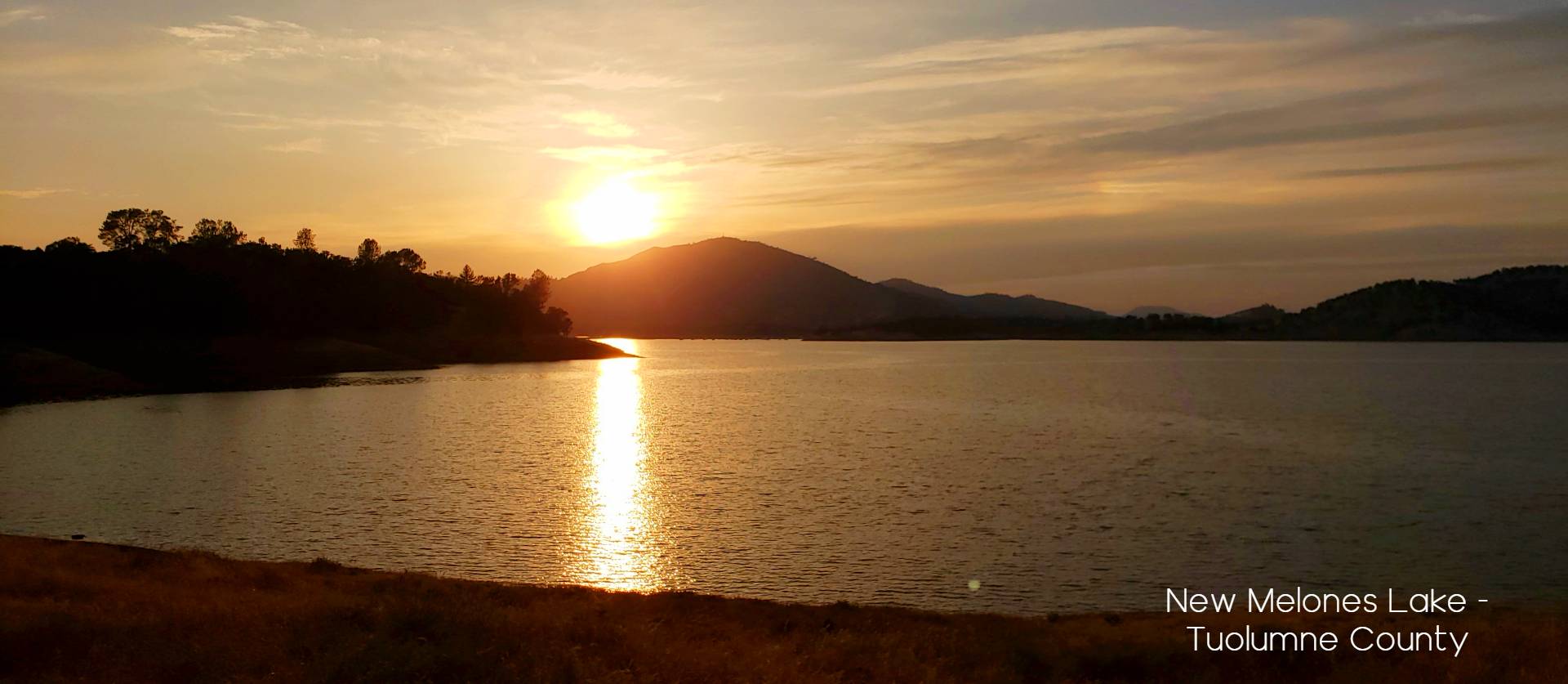
New Melones gave us something better than a roadside hotel. We arrived in time to watch the evening light settle over the reservoir, cooked a simple meal and spent a comfortable night at the campground.
That quiet sunset became the unofficial beginning of the trip.
It is worth checking the current campground status before building your route around New Melones. As of August 2026, the Bureau of Reclamation directs campers to the Glory Hole Recreation Area because the Tuttletown campgrounds are closed.
Why the Thursday-night start works
Leaving after work may feel like adding another travel day, but it changes the rhythm of the entire weekend. Instead of beginning Friday with several hours of driving, you wake up within striking distance of Yosemite’s Highway 120 entrance.
You also get a real evening at the lake rather than sacrificing the first half of Friday to transportation.
Day One: Enter Yosemite Before the Crowds
We skipped breakfast Friday morning.
That may sound extreme on the first day of a vacation, but the plan was deliberate: get into Yosemite Valley before the entrance lines and parking frustrations could dictate the day.
We packed up early, drove through Groveland and entered Yosemite while most visitors were still waking up. By sunrise, we were already in Yosemite Valley. We parked first and then found breakfast, which is one of the simplest pieces of Yosemite advice I can give anyone. For us this meant a parking and breakfast stop at Curry Village.
Do not arrive hungry at ten in the morning and begin circling the Valley while looking for parking, coffee and a plan. Get there early, secure your parking spot and let the day begin from there.
Yosemite does not require a vehicle reservation for entry in 2026, although the regular park entrance fee still applies. Lodging, campground and backpacking reservations remain strongly recommended. Future requirements can change, so always check the National Park Service before leaving home.
Hike the Mist Trail to Nevada Fall

After breakfast, we headed toward Happy Isles and started up the Mist Trail.
This is not a casual walk between scenic overlooks. The climb to the top of Nevada Fall is approximately five miles round trip, gains around 2,000 feet and generally takes four to five hours. The stone steps near Vernal Fall can be wet and slippery, and the full route requires a respectable level of fitness.
It is also one of the defining Yosemite Valley hikes. And if you are brave and wise enough the early morning light becomes your best friend because you are ahead of the streams of visitors that will be behind you for the next few hours.
The trail climbs alongside the Merced River toward Vernal Fall and then continues into the granite walls beneath Nevada Fall. The sound of the water, the spray along the steps and the changing views make the climb feel like a complete Yosemite experience rather than just a way to reach another viewpoint.
Travelers who do not want the full hike can turn around at the Vernal Fall Footbridge or the top of Vernal Fall. The important thing is to match the day to your ability rather than forcing the most difficult version of the route because it appears on an itinerary.
After returning to the Valley floor, we spent the rest of the afternoon visiting several of Yosemite’s familiar highlights. El Capitan, Yosemite Falls and the Merced River are not secrets, but there is a reason they continue to stop people in their tracks.
The advantage of arriving early was that we could enjoy those places without spending the entire day worrying about where to park next.
Finish the Day on Tioga Road

Instead of ending the Yosemite day by retracing our route directly to Sonora, we drove east on Tioga Road toward the high country.
That decision gave us an entirely different Yosemite experience.
Earlier in the day we had looked up at Half Dome from Yosemite Valley. By late afternoon, we were standing at Olmsted Point and looking back toward the same granite landscape from the opposite side.
That is one of the details I remember most clearly from this trip: two views of Half Dome in one day, each from a completely different Yosemite world.
Olmsted Point is accessible only when Tioga Road is open. The road typically operates from late May or June until sometime in the fall, but actual opening and closing dates depend on snow and weather.
From Olmsted Point, we continued to Tenaya Lake for a swim.
After hiking through the heat and activity of Yosemite Valley, stepping into the cold water at Tenaya felt like resetting the entire day. We did not need another major hike or attraction. We needed a quiet place, a swim and time to absorb everything we had already seen.
Services can be limited along Tioga Road and around Tuolumne Meadows, especially near the beginning and end of the operating season. Carry food and water rather than assuming you will find them in the high country.
Pizza in Groveland and a Night in Sonora
By the time we returned west on Highway 120, we were ready for something simple.
We stopped in Groveland for a late pizza before continuing to Sonora, where we stayed at Hotel Lumberjack. The property has since been renovated and describes itself as a reimagined Americana motel in the center of historic Sonora.
The exterior still carries some of that traditional roadside-hotel character, but the rooms felt far more polished than we expected. It became a comfortable base for the next two nights and saved us from moving our luggage every morning.
That was another reason this route worked. We pushed hard during our Yosemite day, but we did not spend the rest of the weekend changing hotels and chasing reservations.
Day Two: Breakfast in Sonora and a Pinecrest Adventure
The second morning began at the Willow Wisp Cafe, one of our favorite Sonora breakfast stops.
After the intensity of Yosemite, there was no need to hurry. We ate breakfast, gathered what we needed for the trail and then started north on Highway 108.
The landscape changes steadily as the highway climbs away from Sonora. Gold Country foothills give way to pine forest, granite and the cooler air of the upper Stanislaus National Forest.
Our main destination for the day was Pinecrest Lake.
Pinecrest Lake and the Hike to Cleo’s Bath
Pinecrest is one of the most accessible mountain-lake destinations in this part of the Sierra. Visitors come to swim, paddle, fish, picnic or walk the trail around the lake.
We had something farther up the trail in mind.
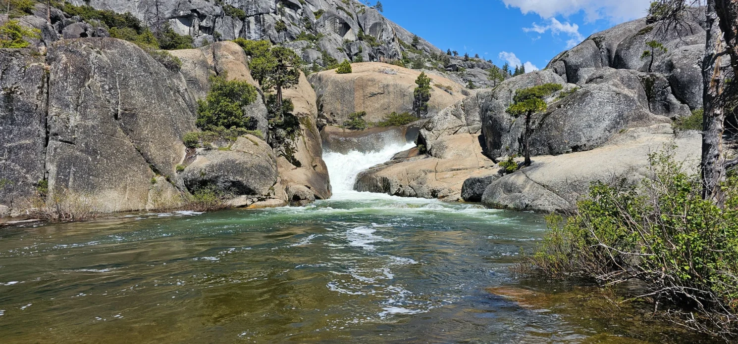
Cleo’s Bath is reached by continuing beyond the main lakeshore and climbing into the granite country above Pinecrest. The route becomes rougher and less obvious as it approaches the waterfall and pools, so this should not be presented as an easy extension of a casual lake walk.
The reward is a beautiful collection of granite, rushing water and cold pools above the falls. The trek up to the top of the falls is not easy and care should be taken to make certain your are up to the task of boulder and granite scrambling.
The waterfall itself can be impressive, particularly when runoff is strong, but the cold soaking pools were what made the afternoon memorable for us. We explored carefully, found a place away from the strongest water and let our tired legs recover.
Waterfall areas require judgment. Granite can be slick, currents can be more powerful than they appear and conditions change dramatically throughout the season. Do not jump from rocks or enter fast-moving water simply because someone else has done it.
This is an adventure worth earning, but it should never be treated casually.
Return to Sonora for the Evening
After Pinecrest, we returned to Sonora for dinner at the brewery and another night at Hotel Lumberjack.
This may look inefficient on a map. We drove up Highway 108 only to come back down again. In practice, it gave us exactly what we needed: a full mountain day without packing the car, changing hotels or trying to coordinate dinner at a remote destination.
Sonora also gave the trip an important change of pace. The evenings felt like part of the vacation rather than empty hours between outdoor attractions.
We could walk, eat well and talk about the day without needing to plan another long transfer before bed.
Day Three: Wildflowers, Foothills and Carlon Falls
We had heard the wildflowers might be showing at the Red Hills Recreation Management Area, so we built our third day around a more relaxed foothill adventure.
Breakfast that morning was at Woods Creek Cafe in Jamestown, before we headed toward the Red Hills.
Located near the intersection of Highways 49 and 120, just south of Chinese Camp, the Red Hills protect approximately 7,100 acres of public land. The unusual serpentine soils support a plant community that looks noticeably different from the surrounding foothills, including a variety of annual wildflowers.
This is not the dramatic granite Sierra people picture when they hear Tuolumne County. That is precisely why the stop belongs in the itinerary.
The open hills, spring flowers and lower-elevation landscape reveal another side of the county. After two days of granite walls, waterfalls and pine forest, the Red Hills gave us room to slow down and explore without a major objective.
Wildflower timing varies every year. Rainfall, temperature and the timing of spring all influence what you will find, so it is better to treat the bloom as a seasonal bonus than a guarantee.
Cool Off at Carlon Falls

We still had time in the afternoon, so we returned toward the Highway 120 corridor for a visit to Carlon Falls.
Carlon Falls is the kind of place that fits this itinerary particularly well. It offers a relatively modest outing compared with the Mist Trail, and the pools near the falls can provide a welcome place to cool off during warmer conditions.
We were not trying to collect another major accomplishment. We wanted a walk, time near the water and a final swim before returning to town.
That distinction matters when planning a multi-day Sierra trip. Every day does not need to be more difficult than the last. Some of the best travel days pair one meaningful outing with enough unscheduled time to enjoy where you are.
As with Cleo’s Bath, visitors should evaluate current water levels and avoid slick rocks, cliff jumping and strong currents.
With a few hours to spare we drove down to Hetch Hetchy for a peak over O’Shaughnessy Dam. Such a classic Yosemite view and drive.
Dinner at the Iron Door Saloon
We finished the evening in Groveland with burgers at the Iron Door Saloon.
After three days of moving between Yosemite, Sonora, Pinecrest and the foothills, the old saloon felt like an appropriate place to end the active portion of the trip. It is historic, informal and unmistakably part of the Highway 120 experience.
Groveland is sometimes treated only as the final town before Yosemite, but that undersells its value. It can serve as a dining stop, a place to resupply or an entire base camp for exploring the northern side of the national park.
On this trip, it became a familiar bookend. We passed through on the way to Yosemite, returned after Tioga Road and came back once more for our final dinner.
Day Four: Drive Home Over Sonora Pass
The final day was not simply a drive home.
We left Sonora on Highway 108 and allowed enough time to stop along the way. That decision turned the return trip into one more Sierra adventure.
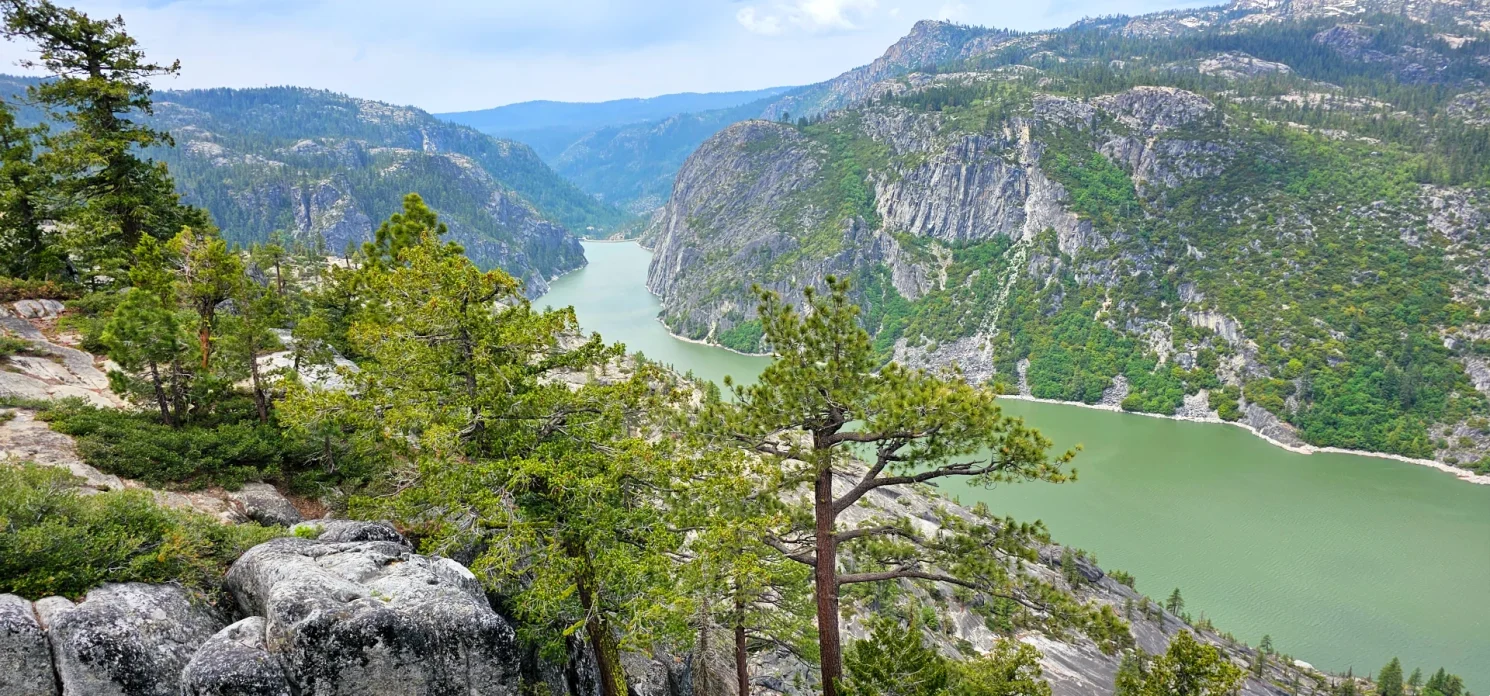
Our first major stop was Donnell Vista. The overlook provides a broad view into the Stanislaus River canyon and across Donnell Reservoir. It is one of the easiest dramatic viewpoints along the Highway 108 corridor and a natural place to pause before continuing into the higher country.
From there, we stopped at Kennedy Meadows.
Kennedy Meadows is more than a roadside resort. It is a historic gateway into the Emigrant Wilderness and the high country surrounding Sonora Pass. Depending on the season and your plans, it can be a place for lunch, horseback riding, cabin stays, fishing or the beginning of a longer wilderness trip.
We were there to enjoy the setting and let the drive unfold.
Beyond Kennedy Meadows, Highway 108 becomes narrower, steeper and increasingly dramatic as it climbs toward Sonora Pass. The route does not feel like an ordinary way home. It feels like a final mountain experience.
Sonora Pass is seasonal and can close temporarily during storms even after its spring opening. Check Caltrans conditions before building a trip that depends on crossing the pass.
By the time we descended toward the eastern Sierra, the trip felt complete. We had not merely visited Yosemite and driven home. We had connected the Valley, Tioga Road, Gold Country and the Highway 108 high country into one broad look at Tuolumne County.
A Slower Alternative: Make Groveland Your Base Camp
The moving road trip works well for travelers who want variety. It is not the right choice for everyone.
More recently, I helped friends plan a different version of a Tuolumne County vacation. They towed their trailer over Highway 88 and Highway 49 and established a four-night base camp near Groveland.
Instead of attempting one large loop, they took one manageable northern Yosemite excursion each day and returned to the same camp each evening.
Their vacation included:
- A Hetch Hetchy hike to the footbridge
- A swim and afternoon at Carlon Falls
- A drive along Tioga Road to Tenaya Lake and Tuolumne Meadows
- A short hike to May Lake
- Time each day to relax at camp and enjoy Groveland
May Lake works especially well in this kind of plan. The hike is approximately two miles round trip with about 400 feet of elevation gain, offering a meaningful high-country destination without consuming an entire day.
This base-camp approach creates a completely different vacation.
There is no daily packing. There are no late check-ins. One person can read or relax at camp while someone else explores town. Families can adjust each morning based on weather, energy and how everyone is feeling.
It also makes Groveland part of the experience rather than a place you pass through on the way to the park.
Which Version of the Trip Fits You?
Choose the Sonora road-trip version when you want to experience several sides of Tuolumne County. It gives you Yosemite Valley, Tioga Road, Pinecrest, Gold Country foothills and Sonora Pass in one connected journey.
Choose the Groveland base-camp version when Yosemite is the priority and you would rather unpack once. It is especially appealing for RV travelers, families, slower-paced vacations and anyone who wants one primary adventure each day.
Neither version is better. They serve different kinds of travelers.
That is one of the lessons I have learned after years of exploring the Sierra: the best itinerary is not necessarily the one with the most stops. It is the one that matches how you actually want to travel.
Planning Your Tuolumne County Road Trip
Start early for Yosemite
An early arrival does not guarantee an empty park, but it gives you a better chance of parking before the busiest part of the day. Eat after you park rather than adding unnecessary stops before reaching the Valley.
Do not underestimate the Mist Trail
The hike to Nevada Fall is strenuous. Carry water, wear appropriate footwear and be prepared for wet, slippery steps. Build a shorter version around the Vernal Fall Footbridge or Vernal Fall when the full route does not fit your group.
Check all three mountain corridors
This trip depends on several seasonal roads and recreation areas. Before leaving, check:
- Yosemite National Park conditions for Tioga Road and trail closures
- Caltrans conditions for Highway 108 and Sonora Pass
- Stanislaus National Forest alerts
- New Melones Lake campground status
- Current fire restrictions and air quality
Carry food and water into the high country
Services around Tioga Road, Tuolumne Meadows, Kennedy Meadows and Sonora Pass may be limited or seasonal. Do not allow a closed store or restaurant to become a safety problem.
Respect cold and fast-moving water
Tenaya Lake, Cleo’s Bath and Carlon Falls may look inviting, but Sierra water can remain dangerously cold. Runoff, currents and slippery granite change throughout the season.
Give yourself permission to remove a stop
The itinerary is meant to create possibilities, not pressure.
Skip Red Hills when the weather is too hot. Shorten the Mist Trail when your group is tired. Spend an entire afternoon at Pinecrest instead of hiking farther. Stay at Tenaya Lake longer when no one wants to leave.
A great Sierra trip should feel full, but it should not feel like a race.
Why This Tuolumne County Itinerary Works
Tuolumne County rewards travelers who look beyond a single entrance gate.
Yosemite Valley gives the trip its unmistakable landmarks. Tioga Road opens the door to a completely different high-country landscape. Pinecrest and Cleo’s Bath add water and exploration. Sonora gives the evenings character. Red Hills introduces the foothills, while Donnell Vista, Kennedy Meadows and Sonora Pass turn the drive home into one last reason to keep looking out the window.
I have made versions of this trip from different directions and helped other travelers reshape it around their own pace. The exact stops can change. The structure is what makes it work.
Begin by getting close. Give Yosemite one focused day. Use Sonora or Groveland as a real base rather than just a place to sleep. Let Highway 108 become its own adventure. Most importantly, leave enough space between the major attractions to discover the places you did not originally build the trip around.
That is often where the best part of a Sierra road trip begins.