
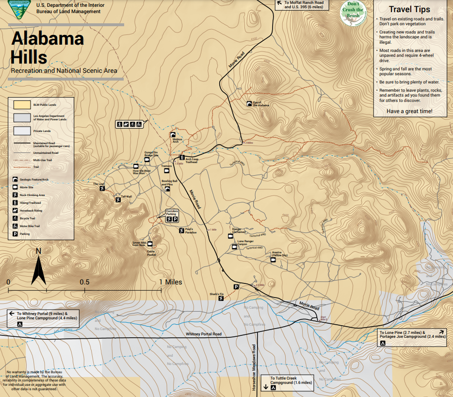
Movie Rd and Movie Flat Now Day Use Only
October 2021 – Alabama Hills has been experiencing a slow “loved to death” for many years. For this reason a new management plan had to implemented this year by the BLM. The new Management plan which was rolled out earlier this summer included new restrictions on Camping areas and day use areas in Alabama Hills.
As of October 1, 2021 the west side of Movie Road in the Movie Flat area and any area marked with a no camping sign will be day use only areas (see map). Additional changes to dispersed camping will occur throughout the fall. These changes will include a required free permit and further delineation of areas where camping may occur. Eventually, camping will be limited to sites identified with a campsite marker in the areas shown on this map.
Camping
The best place to camp when you visit the Alabama Hills is at the nearby campgrounds, all within a few miles of Movie Road. This includes the BLM Tuttle Creek Campground (https://www.blm.gov/visit/tuttle-creek-campground-0), the Inyo National Forest Lone Pine Campground (https://www.fs.usda.gov/recarea/inyo/recarea/?recid=20686) and the Inyo County Portuguese Joe campground (https://www.inyocounty.us/services/parks-recreation/portuguese-joe).
To control human waste, six porta potties have been placed in the Alabama Hills. Please either use these restrooms or pack out your solid human waste using a portable waste system (RV toilet, wag bag, portable toilet, etc.).
Overview
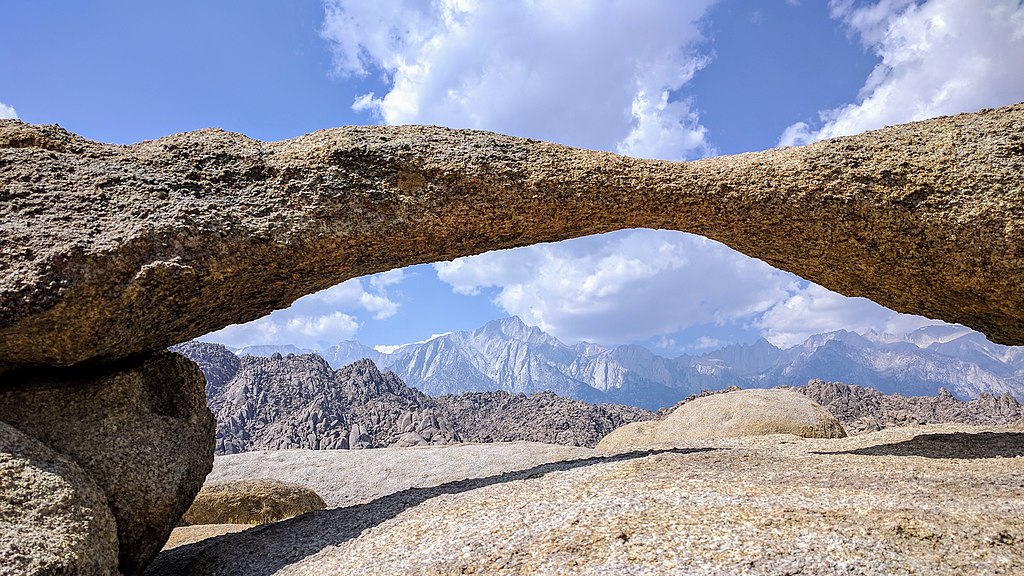
The Alabama Hills are a formation of rounded rocks and eroded hills set between the jagged peaks of the Sierra Nevada and the geologically complex Inyo Mountains. Both geologic features were shaped by the same uplifting occurring 100 million years ago.
Visitors enjoy touring film sites, photography, rock climbing, exploring natural arches, and viewing the swaths of wildflowers that bloom every spring. Horseback riding and mountain biking are popular activities.
The Alabama Hills Recreational Management Plan
“The Alabama Hills management plan is the culmination of over 12 months of focused work by dedicated BLM Bishop Field Office resource management professionals, built on wide-ranging and passionate public participation that included highly engaged local stakeholders from the Alabama Hills Stewardship Group, Lone Pine Paiute-Shoshone Tribe, City of Los Angeles Department of Water and Power, Inyo County and the Lone Pine community,” said Bishop Field Manager Steve Nelson. “The level of public interest and engagement in this planning effort speaks to the importance of this unique and special place. We look forward to implementing the plan with continued consultation, coordination and engagement with our partners, local communities and stakeholders.”
Set between the jagged peaks of the Sierra Nevada and the Owens Valley, the Alabama Hills are a unique formation of rounded rocks and eroded hills encompassing more than 29,000 acres of public land that is well known for its mix of scenic, cultural, geological, educational, biological, historical, recreational, cinematographic and scientific values. More than 150,000 people from across the country and around the world visit the Alabama Hills each year. In March 2019, the John D. Dingell, Jr. Conservation, Management, and Recreation Act designated 18,745 acres of the Alabama Hills as a National Scenic Area and directed the BLM to develop a comprehensive management plan for the area within three years.
In addition to recreation, the plan includes targeted actions designed to maintain and enhance the other resources and values of the Alabama Hills, including fuels treatments to help reduce the risk and spread of catastrophic wildland fires. The plan also provides for ecosystem and resource improvement projects to conserve, protect, and enhance cultural and historical resources, popular movie locations, and native plant communities and wildlife habitats including riparian areas and sensitive species habitats. The plan maintains and streamlines film and special recreation permit activities.
The actions identified in the management plan were analyzed in a preliminary environmental assessment, with additions and modifications based on comments received during the public review period. The plan includes a strong adaptive management component and employs an implementation strategy that allows for monitoring results and adjusting accordingly based on desired outcomes.
FAQ Alabama Hills
Visitor Center
At the Eastern Sierra Visitor Center you can view Mt. Whitney, the highest peak in the “lower 48 states” and plan a trip to Badwater Basin in “Death Valley, the lowest place in North America. While you’re here, explore our interpretative displays, book store and native plant garden.
Staffed by a combination of U.S. Forest Service, National Park Service, Bureau of Land Management, and Eastern Sierra Interpretive Association employees, we provide visitor information for wilderness, campground, highway and weather conditions for the Eastern Sierra.
US-395 and CA-136, Lone Pine, CA 93545
Hours
May 1st – Nov 1st: Open Daily, 8AM – 5PM
Closed: Thanksgiving Day, Christmas Day, and New Year’s Day.
Last permit issued and pass sold 15 minutes prior to close.
Directions
Located two miles south of Lone Pine, CA 93545, at the junction of U.S. 395 and State Route 136. No overnight parking.
DAY USE- Alabama Hills
- Tour film sites. Explore the locations of over 400 movies that have been filmed here.
- Take pictures. The Alabama Hills scenery has been an inspiration for photographers for decades.
- Have an adventure. Hike, fish, rock climb, explore natural arches, mountain bike, ride horses, view the wildflowers, or find your own adventure
Overnight Use Alabama Hills
Camping in campgrounds helps maintain the great scenery and recreational opportunities. City of Los Angeles owned lands in the area are open for day use only.
Tuttle Creek Campground. Offers more than 80 sites for affordable camping with spaces for tents, RVs, and trailers. The campground boasts views of Mt. Whitney, and has large campsites with plenty of space for longer vehicles. Drinking water and restrooms are available. Tuttle Creek runs through the campground, providing fishing and birding opportunities.
Portuguese Joe Campground and Lone Pine Campground. Located just east of the Alabama Hills
Camping outside of developed campgrounds in the Alabama Hills will be limited to areas shown on this map and marked with a campsite marker. To control human waste, six porta potties have been placed in the Alabama Hills. Please either use these restrooms or pack out your solid human waste using a portable waste system (RV toilet, wag bag, etc.).
How to Enjoy Alabama Hills for Generation to Come:
- Pack out all trash. There are no trash services. In the high desert environment, even natural items like orange peels take years to decompose.
- Travel on existing roads and trails. Vegetation in this climate can take decades to recover when crushed by off road driving or parking
- Camp in campgrounds. Using campgrounds reduces the number of vehicles, so that the great views are not blocked.
- Use the restroom in town or at nearby campgrounds. If that isn’t an option, bury human waste in catholes 6 inches deep and 200 feet away from waters, trails and camp. There are no restrooms in the hills.
- Have a great time. The Alabama Hills are a great place to explore natural wonders and experience your public lands.
Safety First
- Don’t recreate alone. Leave an activity plan with friends, family, or a ranger that details where you will be and when you expect to return.
- Have a communication plan. Cell phone signals might not always be available.
- Carry/ drink as much water as possible. At least one gallon per person per day is recommended.
- Protection from the sun. Dress in layers, wear a hat, sunglasses, protective clothing, and sturdy footwear. Bring warm layers and a waterproof shell on longer hikes – the weather can change quickly.
- Know the trail. Carry a map and pay attention to the terrain so you can find your way back.
- Beware dangerous plants and animals.
- Keep children near you and stay on the trail.
- In an Emergency: Inyo County Sheriff (760) 878-0383
- Nearest hospital: Southern Inyo Hospital (760) 876-5501, 501 E Locust Street, Lone Pine, CA
Images Courtesy of BLM
