An Great Fall Day Hiking the West Charity Valley trail
Alpine County, California – The fall season is my favorite time to hike in the Sierra. And because of the many hiking options, I only hike trails once if the destination is only somewhat worth it. And so I don’t leave the headline as misleading; this day in the Sierra was a first for me. My Hiking partner, part-time writer, and editor at Sierra Rec Magazine, Tom Trelenberg, had hiked this trail several times. In 2014 when he first wrote about it on the website, he told me it was one of his all-time favorite local hikes. So why it took me until this year to make my way to this local area is beyond me.
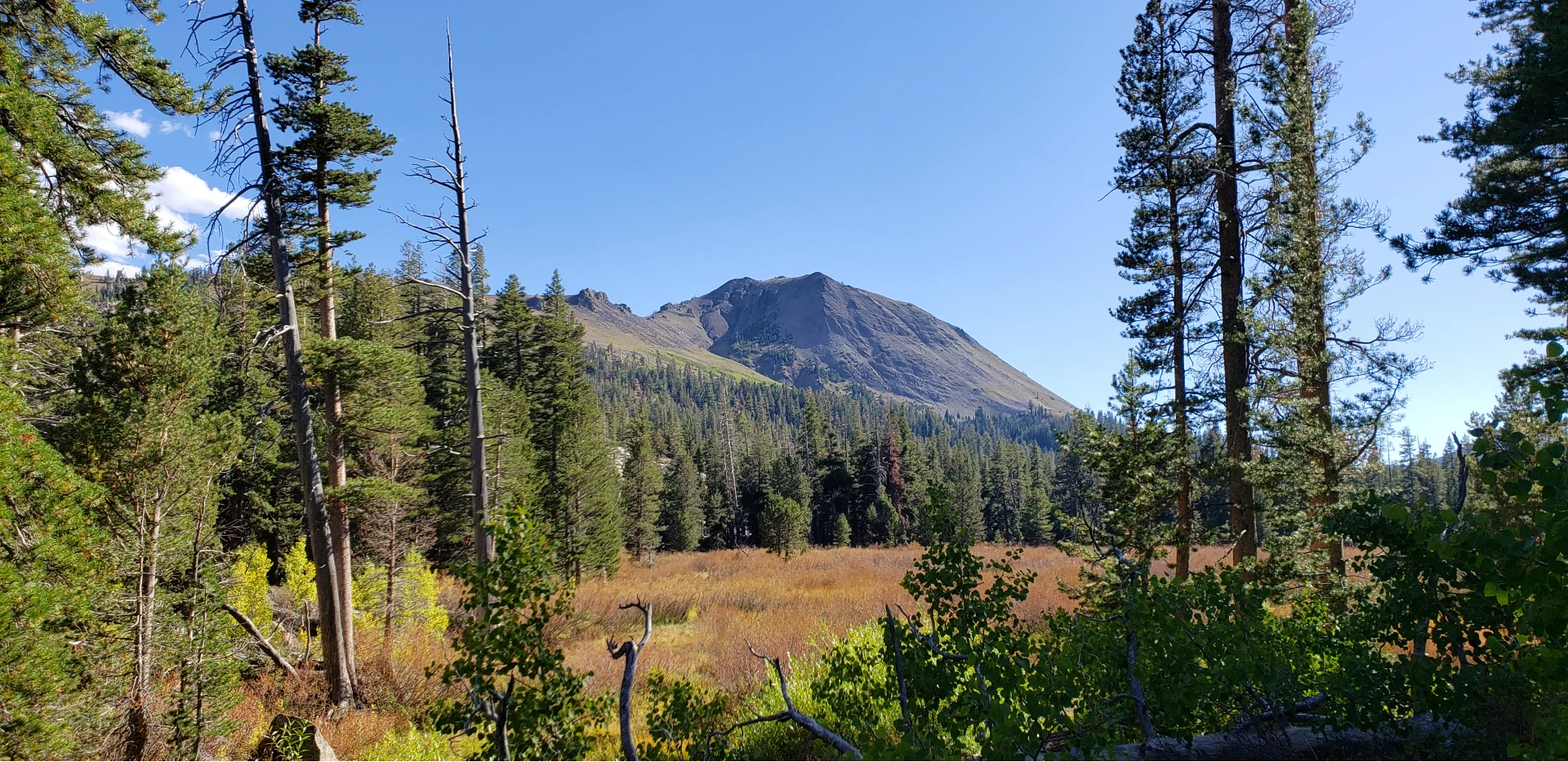
The West Charity Valley Trailhead is located 6.3 miles south on Blue Lakes Road off Hwy. 88. Unlike in 2014, there now is a small sign that simply says trail next to the road to help mark your starting location.
The trail has no official destination, although it connects with trails to Burnside Lake and down into Grovers Hotsprings State Park via the East Charity Valley Trail. As we would discover later in our day, the remnants of the Tamarack fire in 2021 are felt and seen from the region where these trails all meet.
Charity Valley History:
In the summer of 1848, Hope Valley was named by Mormons, including 45 men, 17 wagons, and a young woman called Melissa Coray.
However, Charity and Faith valleys were not named until later. In 1855 an exploring party out of Murphy’s was looking for a wagon route to get Gold Rushers to the southern mines from Hope Valley to Murphy’s. As they were exploring west to east, they discovered and named Indian Valley. Proceeding on the party came into a valley they called Charity Valley and found another valley named Faith Valley. The following year one of the exploring parties built a road over that route, which would come to be called the Big Tree Carson Valley Wagon Road. Parts of this road are now Blue Lakes Road.
Charity Valley Trailhead is located 6.3 miles south on Blue Lakes Road off Hwy. 88, and seasonally, is one of the most beautiful hikes in our area.

The Trail Experience & Charity Creek
Hikers on this trail will experience many different terrains and features as the trail crosses above the Charity Valley working farm to the South of the path, just below Markleville Peak. The trail crosses into cattle property and has a functioning gate that hikers can open and lock behind themselves. The trail crosses over a barren hillside for the first half mile, giving way to stunning images of Markleville peak and the Charity Valley below on a clear day.
Roughly a half mile in the trail will drop into the forest and work itself around to Charity creek, which will follow the trail for the next several miles. The charity creek area is stunning. The stream is teaming with fish and has all the seasonal colors you would expect, with plenty of water sources for plants, flowers, and trees to enjoy.
Charity Creek includes a small waterfall cascading over a large granite flat rock, creating deep pools in the late summer and fall after seasonal run-off dyes.
After a small break at the waterfall feature, we found a small region that pinned us between the granite wall to the north and the creek to the South. The trail starts to give way to the mountain at this point and is all downhill. Hiking another mile, we discover the first glimpse of the tamarack fire scar. A rugged terrain that zigs its way down the canyon and into the fire scar of the Tamarack fire presented itself. It was like walking into a different world.

The Tamarack Fire Scar
The Tamarack Fire was a wildfire that burned 68,637 acres, primarily in the Mokelumne Wilderness in Alpine County, California, and Douglas County, Nevada. The fire was first reported burning on a rocky ridgetop on July 4, 2021, a result of a lightning strike. The start of the fire is not far from this area on the trail as the crow flies. The fire was allowed to burn naturally due to concerns for fire crew safety in the rugged area, the lack of fuels, and the natural barriers on the ridgetop that limited the fire’s growth.

Seeing this region now, you can visually understand the rugged terrain and firefighters’ struggles with this fire.
On July 16, high winds caused the fire to move down the ridge. High winds, dry fuels, and conditions caused the fire to grow rapidly to 21,000 acres (8,498 ha) by July 17. The fire continued to grow, threatening numerous communities, including Markleeville, and highways in the area, including State Highways 89, 88, and 395.

A New Trail and a Recovering Forest Landscape
As Tom and I descended the ridge on the trail and began to enter into the burned territory, it was apparent why they warned hikers and outdoor enthusiasts to beware. Trees burned to nearly nothing, still standing 50 feet in the air all along the trail.
But through the devastation of the burn, life has returned. Wild raspberry bushes, leafy bushes, and ground cover were abundant in some areas. The creek looks like it may have adjusted course just a bit and the trail becomes almost unrecognizable at one point with underbrush and berry bushes.
Tom & I took a short stop for lunch before we tried to find the trail to Burnside lake, previously marked with a sign. As we sat at lunch, there was a certain beauty to the burn area with all the green leafy underbrush. In hindsight, we should have sat a little longer at lunch because the next hour would have been challenging.
After leaving our lunch spot, we quickly found the trail again and headed down the slope a bit more before we could see the entire Grovers State Park below. Wow, what a devastating fire. How they saved the meadow and the trees around the camping area is beyond me.
Unfortunately, at this point, we started to recognize areas from hiking up the East Charity valley trail before. Realizing we had missed the Burnside trial, we understood that the sign was no more.

Mistakes In the Wilderness
I seldom decided to go off trail in search of a better route and found trouble. Today would be different. After not finding the trail sign and backtracking a hundred yards, we made a fullish decision to make our own path up the side of the ridge with the goal of tucking around the ridge back into the canyon that we knew led to Burnside lake. Exhausted from the effort and steep sandy terrain, an hour later, we found the original trail.
Another long break for Tom and I, then a proper decision was made, to call it a day and turn around, following the trail down the mountain. To our disgust, the old burn nubs of the sign were found directly behind where we sat for lunch.
The trail up to Burnside from here is a bit steep and rugged, and with the time of day and the level of exhaustion we were feeling, it was wise to turn around for the car. At this time that canyon up to the lake is wide open from the burn scar, but you can see the trees up top that go down to the lake.
Trip Back All Up Hill
Of course, our tired bodies and minds now had to prepare for a 4-mile hike back out of the canyons and back to Blue Lake highway. Lucky for us water follows this trail the entire way, so a good afternoon hat soak helped us feel a bit better. The afternoon glow on the color-changing aspens was spectacular. And the crisp fall air gave us a perfect backdrop for photos of Markleville Peak on our return.
I will return to this trail some year in the fall again, hoping to see the full glow of falls color along the stream. Eventually, I will make it to Burnside lake from here, if not simply to say I did it. West Burnside trail has a lot to offer a day hiker in the region.
