
Just seven miles north of Portola, California, Lake Davis is one of those Northern Sierra destinations where the pace of a trip can change as soon as you arrive. Surrounded by pine forests, open meadows and mountain views, the lake has long been a favorite of anglers, camping families and visitors looking for a quieter place to spend time outdoors.
Located in Plumas National Forest, Lake Davis offers camping, trout fishing, boating, kayaking, hiking, mountain biking and wildlife viewing. Winter brings a different experience, with opportunities for ice fishing when conditions permit, snowshoeing and cross-country skiing.
The lake was created in 1967 with the construction of Grizzly Creek Dam. Today, its roughly 4,000 acres of water and 32 miles of shoreline make it an inviting recreation destination near Portola and Sierra Valley.
For some families, Lake Davis is a tradition that stretches back decades. Parents who camped here as children now return with their own kids or grandchildren. Others discover it for the first time while exploring Plumas County. Either way, there’s plenty of room to settle in and enjoy a few days in the mountains.
Camping at Lake Davis
Camping is one of the most popular ways to experience Lake Davis. The recreation area has three primary developed family campgrounds: Grizzly, Grasshopper Flat and Lightning Tree. Each offers access to the lake and surrounding forest, but the facilities and setting differ.

Some campsites can be reserved through Recreation.gov, while others are available on a first-come, first-served basis. Campground services, operating seasons and reservation arrangements can change, so checking the current listings before traveling is recommended.
Grizzly Campground
Grizzly Campground sits along the eastern side of Lake Davis, surrounded by pine forest. The campground offers tent and RV campsites, with picnic tables and campfire rings with grills. Drinking water and flush toilets are provided during the operating season, and there are no utility hookups.
The trees provide shade, although only a limited number of campsites have direct lake views. Coin-operated showers are available nearby at Grasshopper Flat Campground when those facilities are operating.
Grizzly is a good option for families planning to spend their days fishing, boating or exploring the shoreline.
Grizzly Campground information and reservations
Grasshopper Flat Campground
Grasshopper Flat occupies a hillside overlooking Lake Davis, with many campsites offering views toward the water. Pine trees provide afternoon shade, and the campground is conveniently located near boating facilities and the Lake Davis Trail.
The campground accommodates tents and RVs and includes a group camping area. During the main camping season, amenities include drinking water, flush toilets, coin-operated showers and trash service.
For visitors interested in combining camping with hiking, biking and time on the lake, Grasshopper Flat makes a convenient base camp.
Grasshopper Flat campground information and reservations
Lightning Tree Campground
Lightning Tree Campground is another established camping option on the eastern side of Lake Davis. It offers single- and double-capacity campsites for tents and RVs, including some accessible sites.
The campground has a mix of reservable and first-come, first-served camping. Facilities and services vary by season, and showers are available at Grasshopper Flat when operating.
Lightning Tree is also convenient for visitors interested in the Lake Davis Trail and nearby boating access.
Lightning Tree campground information and reservations
Overflow and nearby camping
Additional overflow camping may be available during busy periods when developed campgrounds are full. Availability and services are limited, so visitors should confirm arrangements with the Plumas National Forest before relying on an overflow site.
Crocker Campground, located northeast of Portola, provides another small Forest Service camping option away from the immediate lakeshore. It is a more rustic experience, with vault toilets, picnic tables and fire rings, but no drinking water or trash service.
Important camping note: Dispersed camping is not permitted within the designated Lake Davis Recreation Area. Dispersed camping may be allowed on other National Forest lands outside the recreation area, subject to applicable restrictions. Always check current fire regulations and camping rules before setting up camp.
Fishing at Lake Davis
Fishing has been part of the Lake Davis experience since the reservoir was created. Rainbow trout are a major attraction, and the lake is also known for brown trout and other fish species.
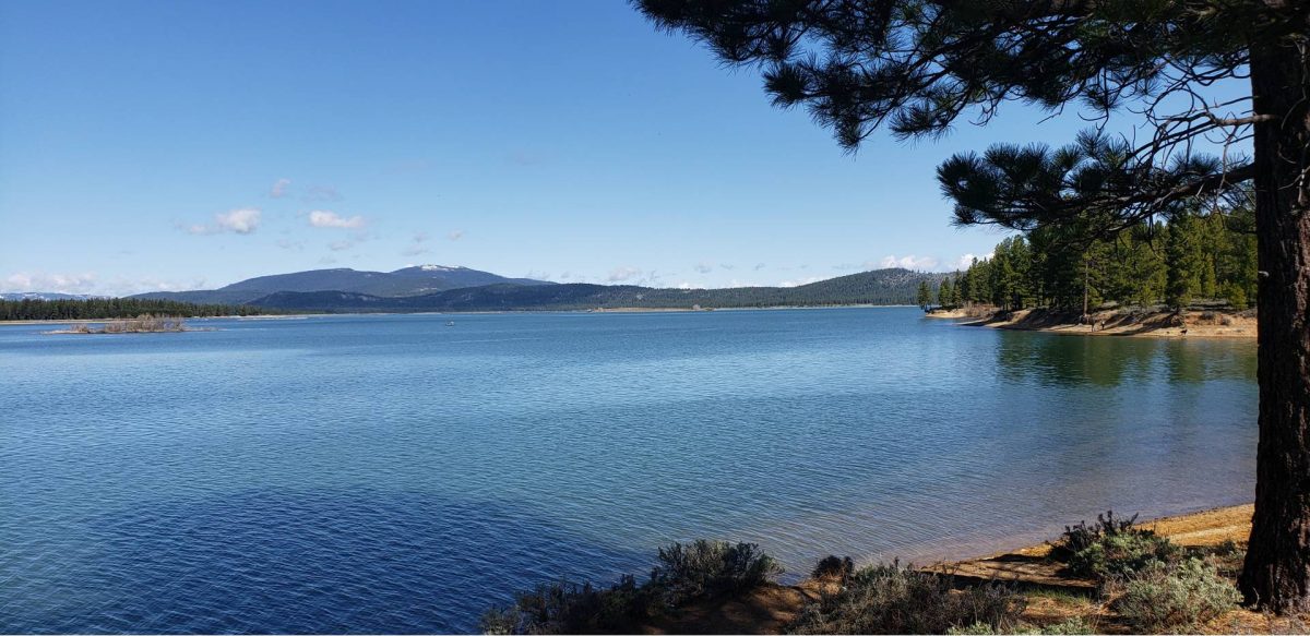
For many visitors, the appeal is as much about the setting as the fishing itself. A morning on the shoreline or an afternoon drifting across the water offers a chance to enjoy the surrounding forest, mountain views and quiet stretches of shoreline.
Anglers can fish from boats or use one of several established shoreline access areas.
Fishing access around the lake
The Lake Davis Recreation Area includes multiple fishing access points. Among the locations identified in Forest Service visitor information are:
- Camp Five, which includes an accessible fishing area
- Bluff Cove
- Coot Bay
- Cow Creek
- Eagle Point
- Fairview Point
- Freeman Creek
- Jenkins Point
- Long Point
- Mosquito Cove
Amenities vary. Some locations have toilets or developed facilities, while others provide more basic shoreline access.
Lake Davis is also a destination for ice fishing during winters when safe ice conditions develop. Ice thickness and conditions can change rapidly, so visitors should never assume the lake is safe to walk on simply because it appears frozen.
Fishing licenses and applicable regulations are administered by the California Department of Fish and Wildlife. Check current rules, limits and any special restrictions before your visit.
California fishing regulations
Boating and Kayaking at Lake Davis
Lake Davis offers boating opportunities for anglers, paddlers and visitors who enjoy exploring a mountain lake from the water.
Fishing boats, canoes, kayaks, sailboats and other permitted watercraft are common during the warmer months. Waterskiing and jet skiing are not allowed, helping maintain the lake’s quieter recreational character.
The Forest Service identifies four developed boat-launch locations around Lake Davis:
- Camp Five
- Honker Cove
- Lightning Tree
- Mallard Cove
Launch access, docks, fees and services can change with lake levels and seasonal operations.
One important consideration is the wind. Lake Davis is known for strong winds that can develop hazardous conditions for smaller watercraft. Paddlers and boaters should pay close attention to the forecast, particularly when traveling away from sheltered shoreline areas.
Hiking and Mountain Biking at Lake Davis
There is more to Lake Davis than the water. Trails and forest roads give visitors opportunities to explore the surrounding pine forests, meadows and viewpoints on foot or by bicycle.
Lake Davis Trail
The Lake Davis Trail is approximately seven miles long and follows portions of the southern and eastern sides of the lake. It passes through mixed-conifer forest and open meadows, with views across the water toward the surrounding Sierra Nevada peaks.
Elevated boardwalks protect sensitive meadow areas, and portions of the trail follow the historic Feather River Lumber Company railroad grade.
The trail is open to hiking, mountain biking and equestrian use. In winter, when conditions permit, it also provides an ungroomed route for snowshoeing and cross-country skiing.
The trail’s development was supported by local community organizations, including the Portola Rotary Club.
Visitors can access the trail from County Road 126 and other points around the recreation area.
Catfish Cove Trail
Catfish Cove Trail provides a shorter opportunity to experience the lakeshore. This accessible trail connects toward a small viewpoint overlooking Lake Davis and a wooded island that becomes particularly noticeable when lake levels are high.
It’s a worthwhile option for visitors looking for a shorter outing rather than a longer hike around the lake.
Exploring the forest roads
Mountain bikers can also explore forest roads surrounding Lake Davis. Some offer relatively gentle rides through the flatter terrain near the lake, while others climb toward the surrounding ridges.
Smith Peak Road provides a more demanding uphill ride. Other forest roads connect the lake area with the surrounding Beckwourth and Sierra Valley landscape.
Conditions vary, and riders should expect occasional vehicle traffic, dust and changing road surfaces.
The Lake Davis area is also associated with the Lost and Found Gravel Festival, which has introduced many cyclists to the region’s extensive gravel-road network.
Smith Peak Lookout and the Surrounding Landscape
West of Lake Davis, Smith Peak rises above the reservoir and surrounding forest. The lookout area is known for panoramic views across Lake Davis, Sierra Valley, Grizzly Creek and the mountain ridges beyond.
On clear days, the view can extend toward Lassen Peak.
Smith Peak is associated with an active fire lookout, so public access to the lookout structure should not be assumed. Visitors interested in exploring the area should check current road and access conditions with the Beckwourth Ranger District.
The surrounding landscape also offers opportunities for wildlife watching, photography and enjoying the contrast between the forests, open rangelands and high-country views.
Winter Recreation at Lake Davis
Lake Davis is not just a summer destination.
Snow changes the character of the recreation area, bringing opportunities for snowshoeing, cross-country skiing and winter photography. The Lake Davis Trail can provide an ungroomed winter route when snow conditions allow.
Ice fishing is another long-standing Lake Davis tradition, but it depends entirely on weather and ice conditions. Visitors should confirm local conditions and exercise appropriate caution before attempting any activity on frozen water.
Winter access to campgrounds, forest roads, boat ramps and other recreation facilities can be limited by snow and seasonal closures.
The History of Lake Davis and Sierra Valley
Long before Lake Davis became a reservoir, the surrounding region was part of the homeland of the Northeastern Maidu people, whose relationship with this landscape extends back thousands of years.
The area’s forests, waterways and meadows supported hunting, fishing and gathering, and the Northeastern Maidu maintain their cultural connections to the region today.
European and American exploration, trade and settlement brought major changes during the nineteenth century. Gold discoveries drew miners into Plumas County, followed by the development of ranching, agriculture, timber operations and transportation routes.
The Beckwourth Trail became an important route across the northern Sierra during the Gold Rush era. Later, railroads helped connect communities and industries across the region.
Highways 70 and 89 now provide modern travel connections through much of the same broader landscape, linking visitors to Portola, Quincy, Sierra Valley and the surrounding mountain communities.
The creation of Lake Davis in 1967 added another chapter to the area’s history, establishing a reservoir that continues to support recreation and regional water needs.

Crocker Guard Station: A Different Kind of Forest Stay
Visitors interested in a more rustic overnight experience can also look into Crocker Guard Station, a historic Forest Service cabin located northeast of Portola.
Originally constructed in 1912, the station once housed Forest Service personnel and their families. The restored building offers a different way to experience the history of the surrounding forest.
The cabin has historically been offered as a rental with sleeping accommodations, basic furnishings and propane appliances, but without running water or conventional electrical service.
Availability, amenities and reservation requirements should be confirmed through Recreation.gov or the Plumas National Forest before planning a stay.
Getting to Lake Davis
Lake Davis is approximately seven miles north of Portola, California, in the Beckwourth Ranger District of Plumas National Forest.
From Reno, travelers can follow U.S. Highway 395 north to Hallelujah Junction, then take Highway 70 west toward Portola.
From Quincy, Highway 70 travels east through the Feather River region toward Portola.
From Portola, County Road 126 provides access toward the Lake Davis Recreation Area. County Road 112 and connecting roads lead to several of the developed campgrounds and recreation facilities.
Because the campgrounds and shoreline access points are spread around the lake, it is worth checking directions to your specific destination before leaving Portola.
Explore More of Plumas County
Lake Davis makes a natural stop while exploring eastern Plumas County, but it can also serve as a base for discovering more of the Northern Sierra.
Portola offers local services and access to the surrounding Sierra Valley landscape. Nearby Graeagle provides another mountain-community experience, with access to Lakes Basin, hiking, golf and additional recreation opportunities.
Travelers continuing west along Highway 70 can explore Quincy and the Feather River corridor. Those planning a longer visit can also connect Lake Davis with other Plumas County lakes, forest trails and scenic routes.
For visitors who enjoy discovering places beyond the best-known Sierra destinations, Lake Davis is a reminder that some of the most memorable experiences are found a short drive away from the main highway.
Plan Your Visit
Before traveling, check current campground reservations, Forest Service recreation notices, fire restrictions and fishing regulations. Services and access can change throughout the year.
- Grizzly Campground
- Grasshopper Flat Campground
- Lightning Tree Campground
- Plumas National Forest
- California Department of Fish and Wildlife
2 thoughts on “Visiting Lake Davis, California: Camping, Fishing, Trails & Recreation”