
A Sierra REC Day Trip Adventure into Plumas and Sierra County Recreational areas.
Graeagle Ca – I absolutely love exploring new areas and finding the hidden treasures of a day trip to a region I have never visited. HWY 89 north of Truckee was one of those regions that I had often looked at on a map and desired to travel, but was always in a hurry and choose a different route. Lucky for me my wife asked me to pick a place for us to go be tourists for the day and learn something new about our area. With the low snow pack this season, it was the perfect opportunity to go up HWY 89 out of Truckee and explore the high Sierra region around Sierraville and Graeagle.
The plan for the day, explore and be a tourist, no particular destination in mind, just go where you want and find a good place for lunch. Yes a good lunch out can sometimes be just the thing.

Heading North on HWY 89 out of Truckee CA., you easily can get sucked into the beauty of the National Forest lands, filled with Ponderosa Pines, sage and mountain streams. We passed multiple camp areas on the side of the road heading towards Sierraville, a few miles before town we found a turn off to Stampede Reservoir, once a great fishing reservoir in the Northern Sierra, we decided to explore this 11-14 mile back road area and see what we could find.
Just a mile or so off the HWY 89 we stumbled onto a interpretive area of the old Washoe Tribe

and the original Basque sheep farmers that settled this area. There is a great Petroglyph in the Kyburz Flat. Apparently this area was once a sacred area that could have been used by the Washoe tribe for all types of ceremonies. Many of the rocks in the area have ground out little pockets that could be nearly 2000 years old.
Kyburz Flat Village
Just down the road from there are the old relics of the Kyburz Flat Village, they have built this great little wooded interpretative deck walk that shows you the old homestead, mercantile, well etc… All while looking over a wildlife refuge sight-seeing area.


This was one of my son’s (16 years old and loves history) favorite finds of the day.
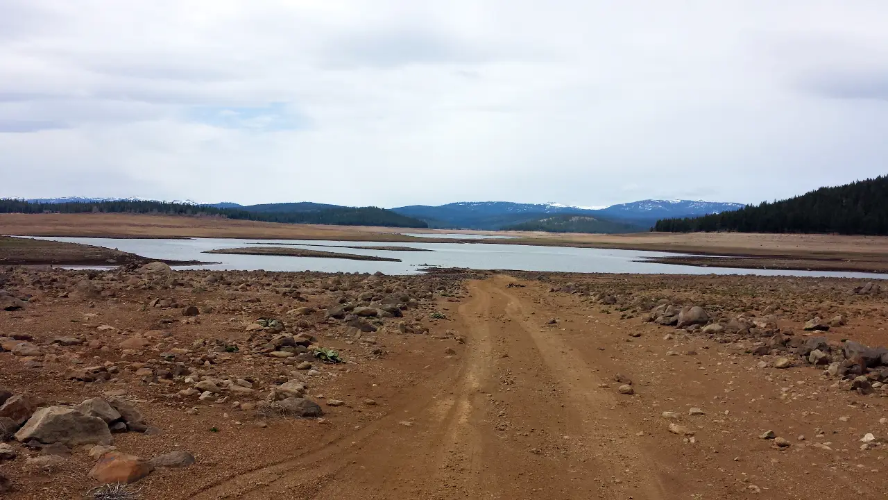
After our stop we completed our trip back to Stampede Reservoir. This road is a bit bumpy and is not recommended for low profile vehicles. But it is a great place for OHV, as we saw several people enjoying their off-road vehicles out here. Unfortunately, Stampede Reservoir was a disappointment and a reminder of how bad our drought in the Sierra is. A once thriving Reservoir is now merely a wasteland of rock, sand and old water plants as the lake is nearly gone.
Sierraville
After our disappointment of Stampede reservoir we looked forward to discovering some of the beautiful places that friends had told us about in Sierraville and Graeagle. Sierraville is a little ranch town based in an absolutely beautiful Alpine region, surrounded by mountains and a valley that opens up to the largest sky. There are very little service here, a gas station and mercantile, Mexican Restaurant , and hot springs hotel. Spoke with a rancher there that said the Mexican Restaurant is really good, but a little early for lunch on this trip so we kept on the road.
Graeagle
We have friends that visit and stay in Graeagle each summer. A popular destination for RVer’s Campers and Day trip recreationalist in the Northern Sierra Region. An old logging town that has transformed itself into a sleepy little resort community. With plenty of Golf courses, RV space and Luxury Cabin and Home Rentals to go around. The main street in town is lined with little red huts that serve as Dinners, Antique and art galleries, candy shops and bike rentals. The old mill-pond now acts as a central park destination and is the feature area for the annual fireworks show that is a popular Sierra 4th of July location for those not going To Lake Tahoe.
We had a great lunch in Graeagle but found many of the shops still closed for winter. Signs saying they were opening next week, oh well guess I get more exploring time.
Johnsville and Plumas-Eureka State Park

We left Graeagle heading north to the edge of town and then took a left up towards Johnsville and Plumas-Eureka State Park. A Beautiful lush mountain region that provides you with hiking, mountain biking, OHV, Skiing, and exploring possibilities.
You will pass A Hiking trail to Madora Lake Trail Loop, Just before Johnsville you turn left back into the campground, which is set in a very lush valley with gorgeous rock bluffs above, tall fir trees in the park and a great stream running through the middle. I particularly love the views of the Rock Bluff’s above. Something very rustic and Rugged about them. Johnsville looks like it is straight out of the gold rush days, you can envision logging and gold miners cohabitating this great little mountain community. As you complete the road to the top of the park (the ski area) it is hard to imagine them skiing up here but under normal snow condition each winter they hold the annual Winterfest festivals for Plumas County here. A tradition that had to be canceled this year but looks like a lot of fun traditionally.
Gold Lake Forest Hwy & The Lake Basin Recreational Area
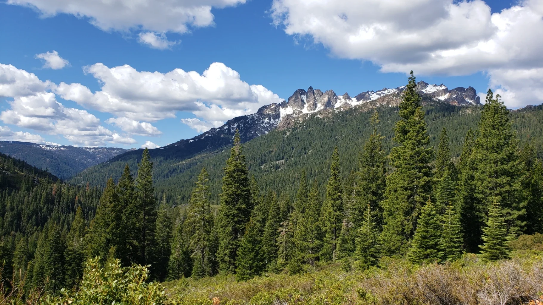
Just south of Graeagle is the Gold Lake Forest HWY leading to the Lake Basin Recreational area. I know now that when I come back to explore this region to give this area a day or two by itself. What an awesome trip. Normally not open this early in the season, a great spring blessing to head over this scenic roadway in early spring. Snow covered peaks of Sierra Butte (a great summer Hike I hear), Lakes lapping at the shores just off the road, Frazier Falls easily accessed, trails and so much more. This is area is Shared between Plumas County and Sierra County and I’m sure that they both use it to promote tourism as much as possible. If you like mountain lakes that are clear and cold from snow melt, hiking in the alpine region with granite and lush trees and manzanita brush then this area is your paradise.
We passed several trails up the mountain, stopped quickly for a picture of Lily Lake

(the first lake you can see from the roadside), Then made our way to Gold Lake. Accessed at two points, the first comes into the south edge and is a great day use area that gives you a great view of the Mountain Range above ( that Range is where the PCT Trail crosses in the region) the second is just up the road and is where the boat ramp is at for Gold Lake. There was one boat out fishing on this day. I can only imagine how great it was to be fishing this early in the year up there.

Frazier Falls
After our stop at Gold lake we crossed the road (literally) and drove 1.5 miles down to Frazier falls. If you have done this trip before and not gone down to the falls, do your self a favor and make the trip next time. This is a must do on this road trip. It is a dirt road but well maintained and easy to get to with any vehicle. Frazier falls area is well maintained and gives visitors a paved 1/2 mile path to a great viewing area of the falls. The Waterfall is a very pretty stair step fall that pours into a valley that runs down toward Graeagle and Sierraville.

The path to Frazier falls is really easy stroll. (If you are using a wheelchair or walking devise the path can get tight and could be considered difficult as it has a couple little climbs and switchbacks.) The waterfall is set in a lava flow cliff and is not the biggest river/creek but it is quite the sight.
At this point in our trip we have been going for about 6 hours and it is time to head back towards Truckee and Lake Tahoe Basin for dinner. So we head South on the Gold Lake HWY towards HWY 49 and the Yuba River area. Along the way we passed several roadside lakes including Goose Lake, Haven Lake, Snag Lake & access to Lower Salmon Lake.
Traveling HWY 49 back towards Sierraville is an adventure as many of the corners are extreme and should be taken at appropriate speeds.
If you are looking for a family road trip this spring or summer, we highly recommend a visit to this area. The Gold Lakes HWY was a highlight for obvious reasons but with a little sense of adventure, there is so many things to discover. If you go send us your added adventure tips or secret finds. We would love to hear what your favorite parts of this region.
Sierra REC Magazine is dedicated to sharing the events, news and adventure opportunities that exist in The Sierra Mountains. From Lassen Volcanic National Park to the North down through the Central Sierra and the Lake Tahoe Basin through the rugged eastern slopes of the Mono county and Yosemite National park to the southern tips near Sequoia National Park and the PCT trail. We invite you to share stories, trips and photos from your adventures in the Sierra. Please join us on Facebook, TwitterGoogle + and You-Tube or email us your events and photos at sierrarecinfo@gmail.com #goexplore
