
Recovery from the Dixie Fire Continues as Lassen Volcanic Park Clears Trees for Safe Camping
Lassen Volcanic National Park – July 28, 2022 – Lassen Volcanic National Park announced today via its social media pages that they have officially opened the camping areas at Juniper Lake on the East side of the park.
The Juniper Lake Campground is located on the east shore of Juniper Lake via a 13-mile paved/gravel road. All single campsites are first-come, first-served only. Reservations are required for the two group sites and one stock corral. Drinking water is not available.
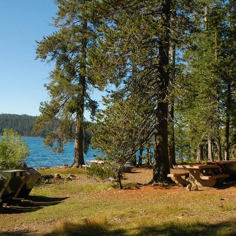
Juniper Lake Campground is now open! All campsites are available on a first-come, first-served basis only. Park staff have removed hazard trees within the campground, however burned hazards still exist. https://t.co/AlDO478ids. 📷: Effects of 2021 Dixie Fire at Juniper Lake. pic.twitter.com/CoVpPEIJ8c
— Lassen Volcanic NP (@LassenNPS) July 28, 2022
Juniper Lake Stock Corral
Juniper Lake Stock Corral is closed for the 2022 season.
The corral is located between the Juniper Lake Ranger Station and the entrance to the Juniper Lake Campground. The stock corral area has two adjacent metal corrals with water troughs. A vault toilet is provided for corral users. There is a limit of 8 animal, 10 people, and 4 licensed vehicles. Water for stock animals may be obtained from the nearby lake; campers must bring water for human consumption. Make a reservation for the Juniper Lake Stock Corral or learn more about stock corrals in the park.

Juniper Lake Road
Juniper Lake Road access – This remote road travels no from from Chester (Hwy 36E). It is paved for the first 6 miles. The remaining 7 miles are rough gravel and rock. A section of the county road just before the park boundary has large rocks and hazards and is recommended only for high-clearance vehicles. Road is generally not advised for RVs, trailers or vehicles with very low clearance.
Be Alert in Open Burned Areas
Lassen Volcanic National Park limits hazard tree removal to developed areas such as the highway corridor, day use areas, and campgrounds. The park is prioritizing efforts to rehabilitate popular trails within the burn footprint as soon as possible. Be alert for and prepared to respond to hazards within open burned areas.
Falling/Fallen Trees or Limbs
Branches and trees may fall, whether dead or alive, and when there is no wind. Even a tree that looks robust may be at risk of falling because of damaged root systems or fire-loosened soils. Look up often and listen for cracks or snapping from roots, trunks, or branches. Take note of and do not stop under fire-weakened trees, snags, and branches. Travel through burned areas quickly to minimize your risk of these hazards.
Undefined or Unmarked Trails
Trails through burned areas may be difficult to follow and signs may have burned. Bring a map and pay attention.

Loose or Falling Rock
Burned soil can be loose when stripped of vegetation and the normal freeze-thaw cycle can further loosen rocks. Pass one person at a time through hillsides in burned areas or if you encounter a downed log or pile of fallen rocks, in case the material shifts.
Hidden Stump Holes
Hallow cavities are created when fire burns stumps or root structures. These holes may be invisible under ash or pine needles until you foot breaks through. Fire can smolder within these cavities for a long time after the rest of the fire is out. White ash may be a sign of lingering heat or a potential hole. Stay on trails in burned areas.
Increased Danger on Windy or Rainy Days
Don’t go into a burn area if it’s forecasted to be windy. Leave the area immediately if the wind picks up and there are hazards around you. Wind often accompanies rain. Burned soil is less absorbent and rain may create muddy and slippery conditions or flooding as drainages become clogged with trees, rocks, and debris.
Higher Than Normal Stream Flow
Snow may melt more quickly in burned areas resulting in higher than normal stream and creek levels. Most creeks and streams within the park do not pose a drowning hazard for adults, however unexpected wetness can quickly lead to hypothermia.
Unstable Shorelines
Fire can burn vegetation and soil that contribute to the stability of creek and lake shorelines. Try to spread out when crossing waterways within burned areas to reduce your chance of slipping in and to limit your impact to these fragile areas.
Burned Signs
Trail signs or tree markers may be missing if destroyed by fire. Bring a map and compass and pay close attention to your route.


