Calling all backpacking enthusiasts! The moment we’ve been eagerly waiting for is finally here. Well possibly! As the virtual doors swing wide open on permit quota season today, the breathtaking landscapes of Kings Canyon and Sequoia National Park extend an enthusiastic invitation to all adventurers.
Picture yourself traversing untamed trails, scaling peaks, and discovering hidden gems in the heart of nature’s grandeur. In May 2024, you might see spring snowpack making travel unsuitable, unrelentless mosquitos, unpassable waterflow, snow bridges and unstable weather. So, early season Trail quotas are for the brave at heart. Still, the beginning of trail quota season in our National parks does mark a joyous season for backpackers to start planning and dreaming of their next great adventure into the Sierra.

The time has come to secure your spot for an unforgettable journey in 2024. Permits are now available online at recreation.gov – let the countdown to your next excellent trail experience begin!
As the 2024 permit quota season for Sequoia National Park has arrived, the heart of every backpacker is undoubtedly already pounding with excitement. With its majestic landscapes and diverse trails, Sequoia promises an unforgettable summer of exploration along the Great Western Divide.
But Planning 6-month’s out is the first step to securing your dream trips. Use this guide to help you discover more of the Sequoia / Kings Canyon region. Plan out routes with trail maps for Sequoia National Park or Apps like Alltrails+. Then access permit quota registrations at recreation.gov to secure your 2024 permit.
Why Sequoia and Kings Canyon? A Wilderness Like No Other
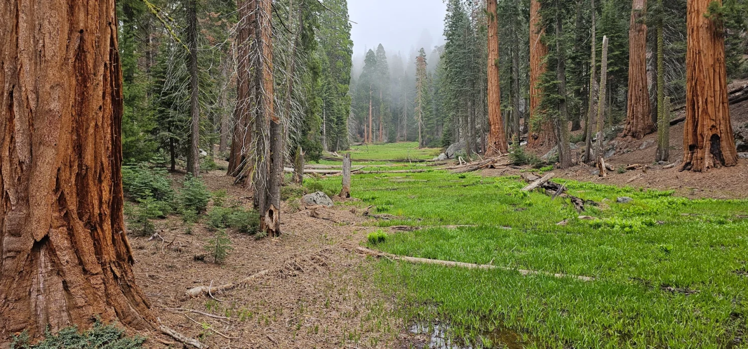
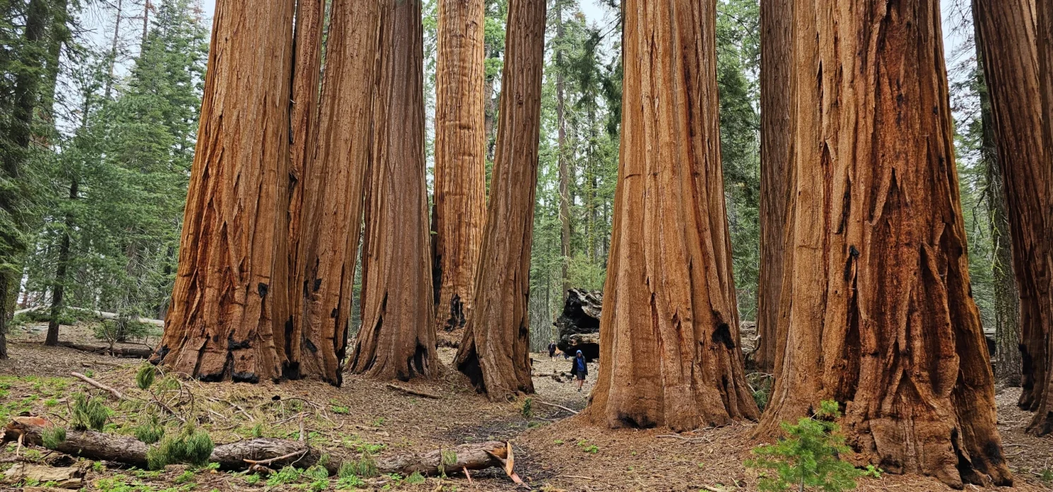
Sequoia and Kings Canyon National Parks stand as a testament to nature’s grandeur, boasting ancient giants, pristine lakes, Glacier Carved Sierra Granite valleys and breathtaking vistas. As you eagerly plan for next summer’s grand adventures, let’s delve into the magic Sequoia and Kings Canyon hold and discover seven must-experience backpacking trails for the upcoming season.
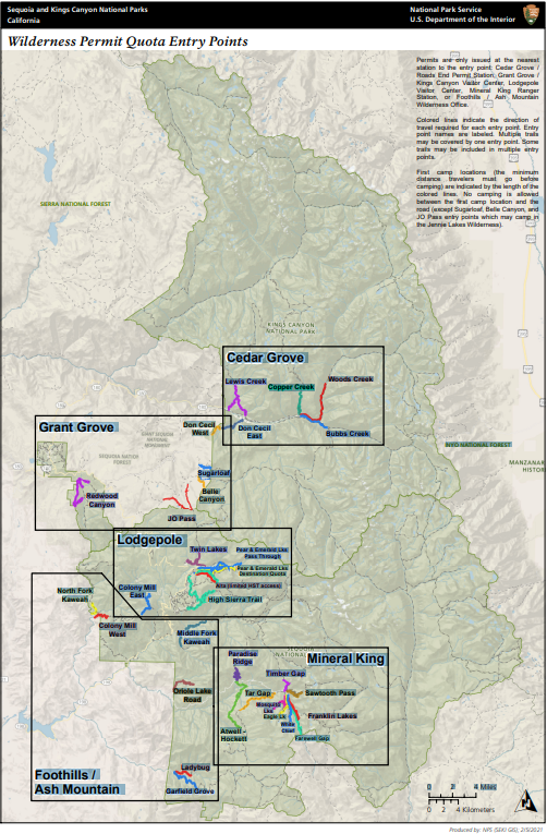
Navigating the intricate web of trailheads and quota sections within Kings Canyon and Sequoia National Park is an exciting venture for backpackers seeking their next wilderness escapade. Let’s break down the key points:
Discover Sequoia and Kings Canyon By regions:
Grant Grove
Wilderness permits for the following trails are only issued from Kings Canyon Visitor Center (in Grant Grove). You will get your wilderness permit from the Kings Canyon Visitor Center if you enter the parks from the Jennie Lakes Wilderness. If you remain in the Jennie Lakes Wilderness without entering the parks, no permit is required.
Redwood Canyon Trail: **Currently closed due to damage from KNP fire.** Begins at the Redwood Saddle trailhead. Mostly easy hiking. Two easy six-mile loops through the park’s largest giant sequoia groves. Two-night camping limit. The maximum group-size is ten people. First allowed campsite – Redwood Creek (1 mile).
J.O. Pass Trail: Begins at Big Meadows or Rowell Meadow trailheads in the Jennie Lakes Wilderness. Moderate hike; the first two miles are the hardest. Forests, lakes. First allowed campsite – Rowell Meadow (2.2 miles).
Belle Canyon Trail: Begins at Marvin Pass, Rowell Meadow, or Big Meadows in the Jennie Lakes Wilderness. Moderate hike; the first two miles are the hardest. Forests, lakes, and vistas.
Sugarloaf Trail: Begins at either Marvin Pass, Rowell Meadow, or Big Meadows trailheads in the Jennie Lakes Wilderness. Moderate hike. Spectacular glaciated canyons.
Lodgepole and Giant Forest
Wilderness permits for the following trails are only issued from the Giant Forest Museum.
Twin Lakes Trail: Begins at the Lodgepole Campground. Moderately steep climb. Forests, meadows and lakes. Access to Silliman Pass and Jennie Lake Wilderness. First allowed campsite – Cahoon Meadow (3 miles).
Lakes Trail: Begins at Wolverton. Moderately strenuous climb. Must camp in designated sites. Alpine vistas and lakes. Heather and Aster Lakes are closed to overnight use. First allowed campsite – Emerald Lake (5 miles).
Alta Trail: Begins at Wolverton. Steady climb to Alta Peak: forests, meadows, alpine vistas. First allowed campsite – Panther Gap (3 miles), no water.
**Please note that a High Sierra Trail permit is needed to access the High Sierra Trail between Seven Mile Hill and Kaweah Gap. A permit for the Alta Trail is not valid for travel on this segment of High Sierra Trail**
High Sierra Trail: Begins at Crescent Meadow. There is no water available at the trailhead. Long, easy-going traverse to Bearpaw Meadow. Steady climb to lakes and passes beyond. Canyons, vistas. About seventy miles to Mt. Whitney. First allowed campsite – Panther Creek (3 miles).

Foothills
Wilderness permits for the following trails are only issued from the Wilderness Office near the Foothills Visitor Center.
Middle Fork Trail: Begins near Buckeye Flat Campgroud with a slight grade along the Middle Fork of the Kaweah River. Oaks to pines, rivers & vistas. Early and late season access. Watch out for ticks, poison oak, and rattlesnakes. First allowed campsite – Panther Creek (3.5 miles).
Lady Bug Trail: Begins at the South Fork Campground. Short and steep; trail ends at South Fork Grove (5.1 miles). South-facing trail accessible year-round. Watch out for ticks, poison oak, and rattlesnakes. First allowed campsite – Lady Bug Camp (1.7 miles).
Garfield Grove Trail: Begins at the South Fork Campground. Steady climb; good early season hiking. Giant Sequoias at Garfield Grove and then climbs on to the Hockett Plateau. Watch out for ticks, poison oak, and rattlesnakes. First allowed campsite – Snowslide (4 miles).

Mineral King Valley
Wilderness permits for the following trails are only issued from the Mineral King Ranger Station.
Atwell-Hockett Trail: Begins at Atwell Mill Campground. Easy to moderate climb. Giant sequoia grove, meadows. Ten miles to Hockett Meadow. Popular stock trail. First allowed campsite – Clover Creek (6 miles).
Paradise Ridge Trail: Begins at Atwell Mill Campground. Steep climb; hot and dry. Sequoia grove and vistas. Ten miles to Redwood Meadow. First allowed campsite – Paradise Ridge (3 miles), no water.
Tar Gap Trail: Begins at Cold Spring Campground. Moderate climb. Lakes, forests, alpine vistas. Twelve miles to Hockett Meadow. Popular stock trail. First allowed campsite – Deer Creek (4 miles).
Mosquito/Mineral Trail: Begins at the end of the Mineral King Road. Moderately strenuous climb. Lakes and spectacular vistas. The trail terminates at the first Mosquito Lake; cross-country travel to the upper lakes. The first allowed campsite is at Mosquito Lake #2 (4 miles).
Eagle Lake Trail: Begins at the end of the Mineral King Road. Steady, moderately steep climb. Lake and alpine vistas. First allowed campsite – Eagle Lake (3.4 miles).
White Chief Trail: Begins at the end of the Mineral King Road. Moderately strenuous climb. Lakes and spectacular vistas. The first allowed campsite – White Chief Bowl (2.5 miles).
Farewell Gap Trail: Begins at the Franklin Pass trailhead. Moderately strenuous climb. Access to Sequoia National Forest trails. The first allowed campsite – Franklin/Farewell Junction (4 miles).
Franklin Pass Trail: Begins at the Franklin Pass trailhead. Moderately strenuous climb. Lake and alpine vistas. Popular stock trail. The first allowed campsite – Franklin/Farewell Junction (4 miles).
Sawtooth Pass Trail: Begins at the Sawtooth Parking Lot. Steep, Strenuous climb. Rough unmaintained trail beyond Monarch Lakes. Access to Glacier Pass, Big and Little Five Lakes. The first allowed campsite – Lower Monarch Lake (4.2 miles).
Timber Gap Trail: Begins at the Sawtooth Parking Lot. Moderately steep climb. Forest, lakes. Access to Black Rock Pass and Redwood Meadow trails. Popular stock trail. The first allowed campsite – Timber Gap (2.2 miles), no water.
Sequoia National Forest
Wilderness permits for the following trails are issued by Sequoia National Forest. They can be reached at (559) 784-1500.
Long Meadow Trail: Begins at the Mountain Home trailhead. Moderate climb. First campsite – Summit Lake (7.6 miles).
Fish Creek Trail: Begins at the Jerkey Meadow trailhead. Easy to moderate climb. Water is scarce. The first allowed campsite – Grey Meadow (5 miles).
Sierra National Forest
Permits for trails starting in the Sierra National Forest are unavailable until January 1, 2024. then will be available on a rolling calendar six months in advance.
Wilderness permits for the following trails are issued by Sierra National Forest. They can be reached at (559) 297-0706. Or Online reservations at recreation.gov after January 1st.
Florence Lake Trail: Begins at Florence Lake. Moderate climb. John Muir Trail, Evolution Valley, and Goddard Canyon access point. A boat-taxi across the lake is available from the trailhead in the summer. First campsite – Blaney Meadow (10 miles).
Tehipite Valley Trail: Begins at Wishon Reservoir. Moderate to the rim of the valley. Very strenuous climb into and out of Tehipite. The first allowed campsite – Cow Meadow (4 miles)

Inyo National Forest
Wilderness permits for the following trails are issued by Inyo National Forest. They can be reached at (760) 873-2483.
Piute Pass: Begins at North Lake. Permits were issued from the White Mountain Ranger Station. Moderate to strenuous. Access to John Muir Trail, Evolution Valley, Humphrey’s Basin. First campsite – Lock Leven (3.5 miles).
Bishop Pass: Begins at South Lake. Permits issued from the White Mountain Ranger Station. Moderate to Strenuous. Access to John Muir Trail, Dusy Basin, LeConte Canyon. First campsite – Long Lake (3 miles).
Kearsarge Pass: Begins at Onion Valley. Permits issued from the Eastern Sierra Interagency Visitor Center. Moderate climb. Access to John Muir Trail and Rae Lakes Loop. First campsite – Flower Lake (3.5 miles).
Mt. Whitney: Begins at Whitney Portal. Permits are issued from the Eastern Sierra Interagency Visitor Center and are required for both backpackers and day hikers. Very strenuous, especially to those not acclimated. Be wary of altitude sickness. First campsite – Outpost camp (5 miles). For more information please visit our Climbing Mt. Whitney page.
Cottonwood Lakes: Begins at Horseshoe Meadow. Moderate climb to the Lakes; strenuous climb over New Army Pass. First campsite – Cottonwood Lake #1.

The Trails Unveiled: A Sneak Peek into Sequoia’s Beauty
Backpacking Trips in Sequoia and Kings Canyon National Parks.
High Sierra Trail Expedition:
- Brace yourself for a 71-mile epic on the High Sierra Trail, commencing at Crescent Meadow in Sequoia National Park and concluding at Whitney Portal on the East. Traverse deep river canyons, high alpine peaks, and pristine meadows. This hike offers an unparalleled exploration of the Sierras, ensuring an adventure of a lifetime.
Crystal Lakes Adventure:
- Unveil the hidden gem of Crystal Lakes on a 9.8-mile journey with a 2200-ft elevation gain. Commence your backpacking escapade at the Timber Gap/Sawtooth Trailhead, located at the pinnacle of Mineral King Valley Rd. Traverse meadows, relish alpine vistas, and cross Monarch Creek for an adventure that promises both serenity and excitement.
Little Five & Big Five Lakes Loop:
- Embark on a 26.5-mile odyssey with a staggering 10,000-ft elevation gain through the enchanting Little Five & Big Five Lakes Loop. Day 1 unfolds with a challenging yet rewarding ascent from the Sawtooth-Monarch Trailhead to Timber Gap. Brace yourself for panoramic views and a journey that promises to be as epic as the Sierras themselves.
Franklin Lakes & Franklin Pass Expedition:
- Discover the wonders of Franklin Lakes and Franklin Pass on this 11.4-mile trek with a 2500-ft elevation gain. Set off from the Mineral King Ranger Station trailhead, ensuring you have the required bear containers available for rental. The journey to Franklin Lakes campground unfolds in approximately 6 hours, offering a true taste of Sequoia National Park’s backcountry charm.
Mineral King Exploration:
- Embark on a 30-mile adventure in Mineral King, commencing your journey from the trailhead near the Mineral King Ranger Station. For an optimal experience, consider camping at Cold Springs Campground the night before. This backpacking excursion promises an immersive encounter with the diverse landscapes of Sequoia National Park.
Emerald Lake Hike:
- Commence your 10.4-mile journey to Emerald Lake from the Alta Peak Trailhead in Sequoia National Park. Traverse through a stark and arid landscape, crossing a small creek around 1.5 miles in. Marvel at the beauty of Emerald Lake, surrounded by stunning scenery that defines the allure of Sequoia.
Pear Lake Exploration via the Lakes Trail: Best Sequoia Backpacking Trip for Beginners – At this time these permits are Walk up only.
- Embark on a 12.4-mile hike with a 2300-ft elevation gain to Pear Lake via the Lakes Trail in Sequoia National Park. Whether as an overnight stay or a day hike, this trail promises beauty at every turn, with camping options at both Emerald Lake and Pear Lake.
Big Bird Lake & Moose Lake Expedition:
- Secure a wilderness permit for this 30-mile, 8000-ft elevation gain backpacking journey from Wolverton Trailhead to Big Bird Lake and Moose Lake. Your adventure begins at the left side of the parking lot, leading you through awe-inspiring landscapes that define the allure of Sequoia National Park.
Mount Silliman Summit Twin Lakes Expedition
- Conquer Mount Silliman on an 11.24-mile trek with a 4449-ft elevation gain. Commencing at the Twin Lakes Trailhead near the Lodgepole Visitor Center, this journey promises parking at the campgrounds and campsite options along the Twin Lakes Trail. Brace yourself for a memorable ascent, offering stunning vistas and a sense of accomplishment in Sequoia National Park. Cross over JO pass and make a Lollypop Loop including parts of Belle Canyon and Ball Dome as you traverse the Kings Kaweah divide.
Plan Ahead for the Perfect Backpacking Experience
As a seasoned backpacker, I can’t emphasize enough the importance of planning ahead. Sequoia National Park is vast and varied, offering trails for all skill levels. Whether you’re a first-time backpacker or a seasoned explorer, meticulous planning ensures a safe and enjoyable journey.
Trail Tips and Insights: Your Backpacking Toolkit
- Maps and Trail Guides: Use the digital Park Atlas to create custom route maps and ensure you stay on the right path. Printed maps are also available at park visitor centers and the Sequoia Parks Conservancy Bookstore.
- Permit Stations: Understand the trailheads and permit stations for each trail. For instance, Wilderness permits for the Rae Lakes Loop and Bubb’s Creek Trail are issued from Road’s End Permit Station.
- Conditions and Regulations: Stay informed about trail conditions, campsite regulations, and any trail closures. Check for updates on the official Sequoia National Park website or consult park rangers for the latest information.

Popular Trail Quota Locations include:
Cedar Grove:
- Trailheads: Don Cecil East, Don Cecil West, Lewis Creek, Woods Creek, Copper Creek, and Bubbs Creek.
Grant Grove / Sequoia National Forest
- Trailheads: JO Pass, Belle Canyon, Sugarloaf, Redwood Canyon, Don Ceil West trailheads.
Lodgepole:
- Trailheads: Twin Lakes, Pear & Emerald Lakes (Destination Quota), and Alta (limited HST access). High Sierra Trail (limited HST access at Alta).
Middle Fork Kaweah:
- Trailheads: Timber Gap, Oriole Lake, Tar Gap, Sawtooth Pass, and Mosquito Lakes.
Mineral King:
- Trailheads: Eagle Lake, Franklin Lakes, White Chief, Atwell-Hockett, Farewell Gap, and Ladybug.
Foothills/Ash Mountain:
- Trailheads: Garfield Grove.
As backpackers embark on their journey, this comprehensive breakdown serves as a roadmap to the diverse and enchanting trailheads, ensuring a seamless and well-informed exploration of the stunning terrain that Kings Canyon and Sequoia National Park have to offer.
Adventure Beyond Sequoia: Expand Your Horizon
Sequoia National Park isn’t the only wilderness gem in the vicinity. For additional backpacking adventures, consider exploring trails in nearby national forests like Sierra National Forest, Inyo National Forest, and Sequoia National Forest.
Your Summer of Sequoia Awaits
As you plan for the 2024 backpacking season, let the spirit of adventure guide you.
Important Dates
November 24, 2023: Reservations for the 2024 quota season are available in a rolling window (6 months to 1 week before the entry date).
May 24, 2024 – September 28, 2024 2024 quota season.
Daily entry is limited by the number of people and entry points. A recreation fee is required.
September 29, 2024 – May 23, 2025
Non-quota period. Self-issue wilderness permits are available at visitors centers and not subject to daily entry limits or fee.
Sequoia National Park’s towering trees and breathtaking landscapes promise an extraordinary backpacking experience in 2024. So, gather your gear, plan your routes, and prepare to make memories that will last a lifetime.
The Wilderness awaits—let the backpacking season begin!

