Explore Yosemite National Park by Foot
800+ miles of trails—from valley waterfalls to quiet alpine basins
Yosemite is famous from the road and from its inspiring vistas, but Yosemite National Park is best experienced on foot.
The real soul of Yosemite begins after the first mile—when the crowd noise fades, the trail narrows, and the landscape starts pulling you deeper into granite, meadow, water, forest, and open sky. This is where Yosemite becomes more than a place to look at. It becomes a place to move through.
This Sierra Rec trail hub is designed to help you choose the right Yosemite hiking or backpacking experience based on region, season, difficulty, and the kind of adventure you’re looking for.
Whether you’re planning a first-time waterfall hike in Yosemite Valley, exploring the high country near Tuolumne Meadows, or heading into the quieter backcountry of Hetch Hetchy, this guide will help you choose the right experience and connect you to deeper Sierra Rec trail guides across the park.
Start Here: Choose Your Yosemite Experience
Yosemite offers hundreds of trail options, but most great trips start with one simple decision:
What kind of experience are you looking for?
Use this quick guide to find your starting point.
I Want a Classic Yosemite Day Hike
Start with iconic scenery, waterfalls, and accessible trails.
👉 Best regions:
- Yosemite Valley (link to Yosemite Valley hub page)
- Glacier Point (link to Glacier Point hub page)
These areas offer some of the most famous hikes in the park, with big views and well-marked trails.
I Want to Try Backpacking
Looking for your first overnight or a weekend loop?
👉 Start in:
- Tuolumne Meadows
- Hetch Hetchy (link to Hetch Hetchy hub page)
These regions offer flexible routes, lake basins, and a great introduction to Yosemite’s backcountry.
I Want Fewer Crowds
Yosemite does not have to feel busy. You just need to know where to go.
👉 Look toward:
- Hetch Hetchy (link to Hetch Hetchy hub page)
- Wawona and Mariposa Grove (future hub page)
- Outer areas of Tuolumne Meadows
These zones offer quieter trails and a slower pace.
I Want a Bigger Adventure
Multi-day trips, high passes, and deeper backcountry routes.
👉 Explore:
- Tuolumne Meadows
- Glacier Point and the Clark Range (link to Glacier Point hub page)
- Northern Yosemite from Hetch Hetchy (link to Hetch Hetchy hub page)
This is where Yosemite begins to feel wild and expansive.
I Am Visiting in Winter
Trail access changes, but Yosemite remains accessible with the right plan.
👉 Best areas:
- Wawona and Mariposa Grove (future hub page)
- Yosemite Valley (link to Yosemite Valley hub page)
Snowshoeing and winter hiking offer a completely different way to experience the park.
Explore Yosemite by Region
Yosemite is not one experience—it’s a collection of distinct regions, each offering a different way to explore the park.
Choosing the right region is one of the most important decisions you can make when planning your trip. Each area has its own terrain, pace, and level of accessibility.
Use this guide to explore Yosemite by region and find the experience that fits your trip.
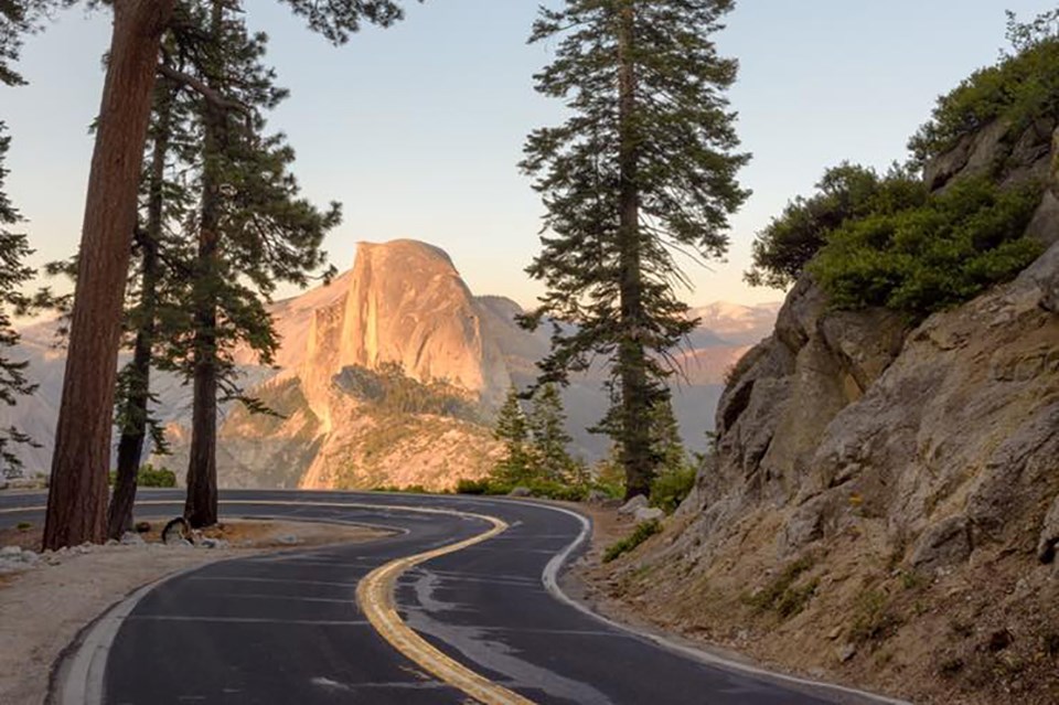
Yosemite Valley
Iconic cliffs, waterfalls, and the most recognizable views in the park.
This is where most first-time visitors start. You’ll find Yosemite Falls, Half Dome views, the Mist Trail, and some of the most famous scenery in the world.
👉 Best for: first-time visitors, classic hikes, short trips
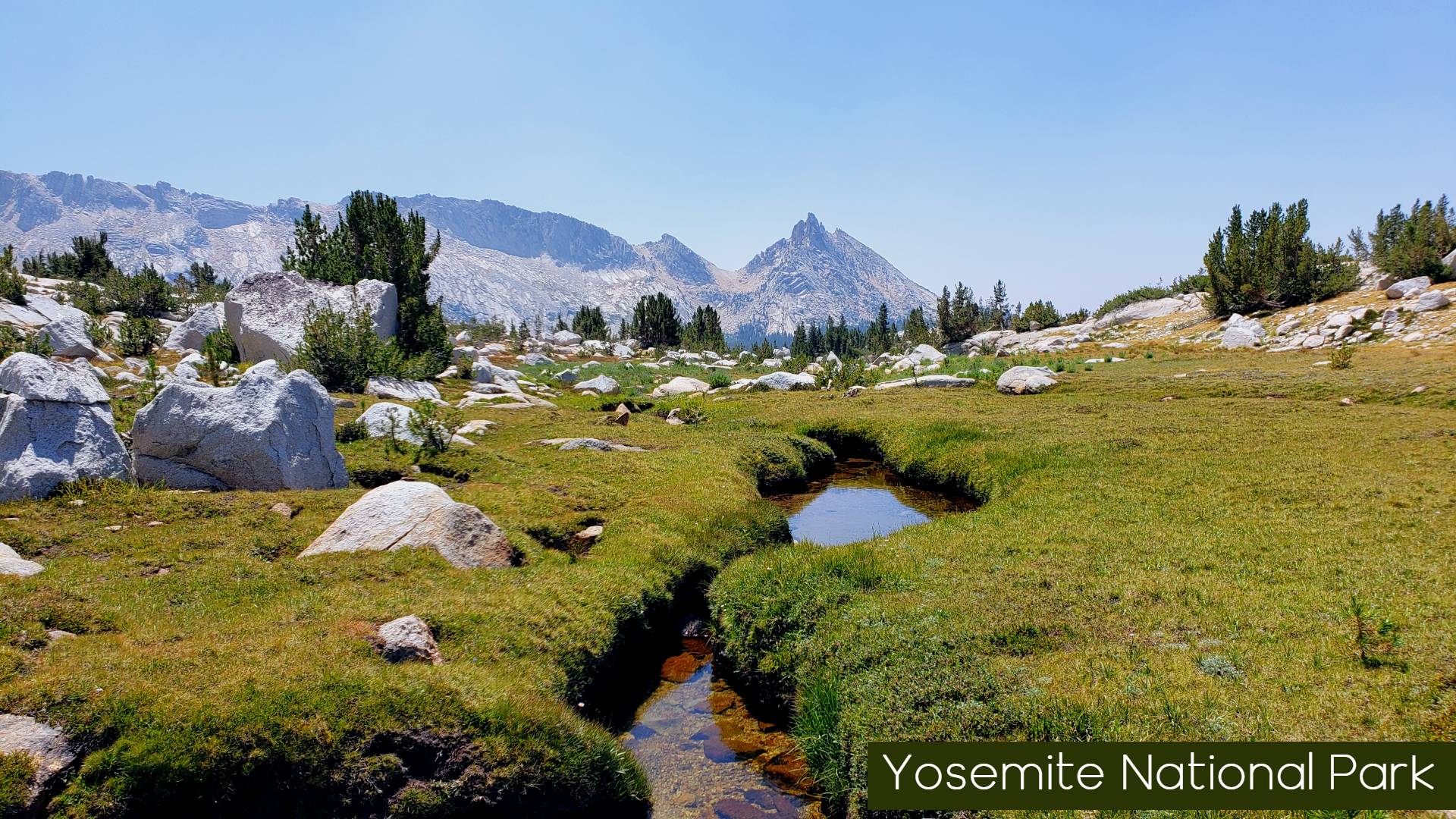
Tuolumne Meadows
Open alpine terrain, high-elevation lakes, and some of the most flexible hiking and backpacking routes in Yosemite.
This is one of the best regions for building your own adventure, whether that’s a day hike to Cathedral Lakes or a multi-day route through the high country.
👉 Best for: backpacking, alpine lakes, high country exploration
Glacier Point and the South Rim
Big views looking down into Yosemite Valley and easy access to high-reward hikes.
This area offers some of the best perspectives in the park, along with access to trails that lead into the Clark Range and southern backcountry.
👉 Best for: viewpoints, sunset hikes, connecting to longer routes
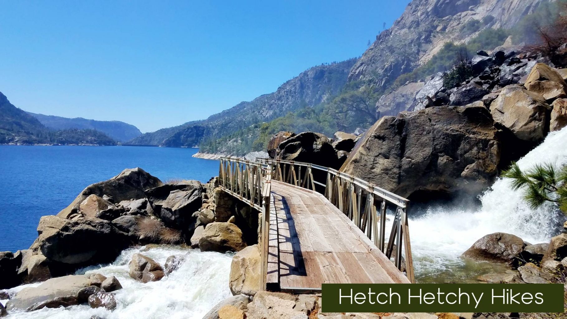
Hetch Hetchy
A quieter Yosemite experience with dramatic granite walls, powerful waterfalls, and fewer visitors.
This region is ideal for early-season hiking and longer day hikes, with access to remote backpacking routes that see far less traffic than other parts of the park.
👉 Best for: solitude, waterfalls, early-season trips
Wawona and Mariposa Grove
A slower-paced Yosemite experience focused on giant sequoias, history, and forested landscapes.
This area offers access to the Mariposa Grove of Giant Sequoias and classic hikes like Chilnualna Falls, with fewer crowds than Yosemite Valley.
👉 Best for: families, sequoias, relaxed hiking
A Sierra Rec Perspective
Most Yosemite trips improve dramatically when you stop trying to see everything and instead focus on one or two regions.
Each area of the park offers a different experience. Understanding those differences—and choosing intentionally—is what turns a busy Yosemite trip into a memorable one.
Yosemite Day Hikes: Start Simple, Then Go Deeper
With just one day in Yosemite, your options are almost endless.
You can choose a short walk to a waterfall, a moderate hike through forest and meadow, or a full-day climb that changes your perspective on the park. The key is not finding the “best hike”—it’s choosing the right hike for where you are and how much time you have.
Start with a few proven options below, then explore by region to find the right fit for your trip.
Featured Yosemite Day Hikes
These are some of the most reliable, high-reward hikes in the park.
The Mist Trail Experience
One of the most iconic hikes in Yosemite.
This route takes you past Vernal Fall and Nevada Fall, combining powerful waterfalls with granite stair climbs and constant scenic payoff.
👉 Best for: first-time visitors, waterfall hiking
👉 Link to Mist Trail guide
Yosemite Valley Loop Trail
A quieter way to experience Yosemite Valley.
Instead of climbing, this trail moves through meadows and forest, offering views of Yosemite Falls, El Capitan, and the Merced River without the same level of crowding.
👉 Best for: relaxed hiking, fewer crowds
👉 Link to Valley Loop Trail guide
Glacier Point to Sentinel Dome
A short, high-reward hike with panoramic views.
Starting near Glacier Point, this route climbs to one of the best 360-degree viewpoints in Yosemite.
👉 Best for: big views with moderate effort
👉 Link to Glacier Point hub page
Cathedral Lakes
One of the best high-country day hikes in Yosemite.
Located near Tuolumne Meadows, this hike takes you to alpine lakes surrounded by granite peaks.
👉 Best for: alpine scenery, moderate challenge
👉 Link to Cathedral Lakes guide
Wapama Falls
A completely different Yosemite experience.
This trail follows the Hetch Hetchy reservoir to one of the most powerful waterfalls in the park, especially in spring.
👉 Best for: early-season hiking, fewer crowds
👉 Link to Hetch Hetchy hub page
Explore More Day Hikes by Region
Instead of trying to see everything in one trip, choose a region and build your day around it.
👉 Yosemite Valley
👉 Tuolumne Meadows
👉 Glacier Point and Yosemite’s South Rim
👉 Hetch Hetchy
Each region offers a different style of hiking, from short scenic walks to longer, more challenging routes.
A Sierra Rec Perspective
The best day hikes in Yosemite are not always the most famous.
Some of the most memorable experiences come from slowing down, choosing the right region, and giving yourself time to explore beyond the main trail.
Start simple, go a little farther than most, and let the landscape do the rest.
Yosemite Backpacking: Go Beyond the Day Hike
If you want to experience Yosemite at its fullest, backpacking is where the park truly opens up.
Beyond the busy trailheads and iconic viewpoints, the landscape becomes quieter, more expansive, and more personal. Granite basins, alpine lakes, river corridors, and high passes begin to connect—and your experience shifts from visiting Yosemite to moving through it.
Backpacking here does require planning. Permits are limited, routes vary in difficulty, and conditions change by season. But the reward is simple:
Space, solitude, and a deeper connection to the Sierra.
Start Here: Choosing the Right Backpacking Trip
The best backpacking trips in Yosemite are not just about distance—they are about choosing the right region and level of commitment.
Beginner Backpacking Trips
If you are new to overnight trips, start with shorter routes that offer strong payoff without extreme mileage.
New: Yosemite Guide Shares Beginner Backpacking Tips
👉 Recommended areas:
- Tuolumne Meadows
- Glacier Point Road
These regions offer:
- shorter approach hikes
- established routes
- access to lakes and scenic basecamps
Moderate Backpacking Trips and Loops
For hikers ready to go farther, Yosemite offers a wide range of loop options and multi-day routes.
👉 Strong options include:
- Tuolumne Meadows to High Sierra lakes loops
- Yosemite Valley to North Rim connections
- Glacier Point to Merced River routes
👉 Link to:
These routes combine:
- elevation gain
- varied terrain
- multiple campsite options
Advanced and Remote Routes
This is where Yosemite becomes something entirely different.
Longer routes move into:
- Hetch Hetchy backcountry
- Clark Range
- Northern Yosemite wilderness
👉 Link to:
These trips often include:
- multi-day loops
- high passes
- route finding or limited traffic
Expect:
- fewer people
- more rugged terrain
- greater commitment
Basecamp vs Loop Backpacking
Not every trip needs to be a long loop.
Many Yosemite backpacking experiences are best done by establishing a basecamp and exploring outward with day hikes.
This approach works especially well in:
- Tuolumne Meadows
- high alpine lake regions
- quieter basins off main trails
Loop routes, on the other hand, allow you to cover more terrain and see a wider range of landscapes—but require more planning and logistics.
Permits and Planning Basics
Backpacking in Yosemite requires a wilderness permit for all overnight trips.
Permits are:
- limited by trailhead
- released in advance and in rolling windows
- required year-round
Fire restrictions, camping regulations, and seasonal access should all be considered when planning your trip.
👉 Link to:
- Yosemite permits and planning section (or future dedicated page)
A Sierra Rec Perspective
There is no single “best” backpacking trip in Yosemite.
The best trip is the one that matches your experience level, your time, and your willingness to go a little farther than most.
Some of the most memorable routes are not the most famous—they are the ones where the crowds thin out, the trail opens up, and Yosemite begins to feel like your own.
Yosemite Permits and Trip Planning
Planning a trip in Yosemite is part of the experience.
With limited trailhead access, seasonal road closures, and changing conditions, a little preparation goes a long way. The goal is not to overcomplicate your trip—but to understand the basics so you can spend more time on the trail and less time figuring things out.
Do You Need a Permit?
👉 Day hikes:
No permit is required for most day hikes.
Exceptions include:
- Half Dome (permit required when cables are up)
👉 Backpacking and overnight trips:
A wilderness permit is required for all overnight stays in Yosemite.
Permits are issued based on:
- trailhead
- start date
- daily quotas
This system helps preserve solitude and protect the landscape.
How Yosemite Permits Work
Yosemite uses a combination of advance reservations and short-term availability.
- A portion of permits are released months in advance
- Additional permits are released closer to your trip date
- Availability is based on your entry trailhead, not your full route
Because of this, flexibility is one of your best tools when planning a trip.
Planning Tips That Make a Difference
👉 Have backup trailheads
Popular routes fill quickly. Having a second or third option increases your chances.
👉 Start mid-week when possible
Trailhead quotas are easier to secure and trails are less crowded.
👉 Match your route to the season
- Spring: waterfalls are strong, but higher elevations may still have snow
- Summer: full access, but higher demand
- Fall: fewer crowds, more limited water
👉 Know basic regulations
- Camp only in designated or legal wilderness areas
- Fires are restricted by elevation and conditions
- Bear canisters are required for food storage
A Sierra Rec Perspective
Permits can feel like a barrier at first—but they are part of what makes Yosemite special.
By limiting access, the park protects the experience for everyone. Once you understand how the system works, it becomes less about competing for a single route and more about finding the right adventure for your trip.
Plan Your Yosemite Trip
Use these guides to continue planning your visit:
👉 Yosemite Valley (link to Valley hub)
👉 Tuolumne Meadows
👉 Glacier Point (link to Glacier hub)
👉 Hetch Hetchy (link to Hetch Hetchy hub)
👉 Yosemite Camping Guide (link)
👉 Yosemite Travel Routes (link)
Frequently Asked Questions About Hiking Yosemite
What are the best hikes in Yosemite National Park?
The best hikes depend on the experience you’re looking for.
- For classic waterfall hikes → Yosemite Valley
- For alpine lakes and high country → Tuolumne Meadows
- For big views and shorter high-reward hikes → Glacier Point
- For quieter trails and fewer crowds → Hetch Hetchy
Choosing the right region is often more important than choosing a single trail.
Do you need a permit to hike in Yosemite?
Most day hikes do not require a permit.
Exceptions include:
- Half Dome (permit required when cables are up)
Backpacking and overnight trips always require a wilderness permit.
What is the best time of year to hike in Yosemite?
- Spring: Best for waterfalls, but higher elevations may still have snow
- Summer: Full trail access, but busiest season
- Fall: Fewer crowds and stable weather, but less water flow
- Winter: Limited access, but snowshoeing and winter hiking are available
Each season offers a different experience depending on where you go.
What is the easiest hike in Yosemite?
Some of the easiest hikes include:
- Lower Yosemite Fall Trail
- Yosemite Valley Loop Trail
- Bridalveil Fall Trail
These are short, accessible hikes with strong scenic payoff.
What is the hardest hike in Yosemite?
Some of the most challenging hikes include:
- Half Dome
- Clouds Rest
- Long backpacking routes through the Clark Range or northern Yosemite
These hikes require strong fitness, preparation, and in some cases permits.
Where should I hike to avoid crowds in Yosemite?
To find fewer crowds:
- Start early in the morning or later in the evening
- Choose less central areas like Hetch Hetchy
- Explore outer areas of Tuolumne Meadows
- Take longer trails beyond the most popular stops
Even in busy seasons, quieter experiences are easy to find with the right approach.
Is Yosemite good for beginner backpackers?
Yes—Yosemite is one of the best places to start backpacking.
Beginner-friendly areas include:
- Tuolumne Meadows
- Glacier Point region
These areas offer shorter approaches, established trails, and great scenery.
How many days do you need to hike Yosemite?
- 1 day: Focus on one region, typically Yosemite Valley
- 2 to 3 days: Combine regions like Valley and Glacier Point
- 4+ days: Explore Tuolumne Meadows or backpacking routes
More time allows you to move beyond the main attractions and explore quieter areas.
Can you hike Yosemite without a car?
Yes, especially in Yosemite Valley.
- Shuttle systems connect many trailheads
- You can access popular hikes without driving
- Other regions may require a vehicle for access
Yosemite Trail Reviews and Latest News
Read the Latest Yosemite News and our personal journey reviews of hiking and backpacking destinations in Yosemite
Yosemite Regions
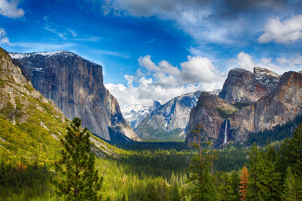
Yosemite Valley – This is the place people are usually thinking of when they think about Yosemite. Many of the things Yosemite is famous for are here: El Capitan and Half Dome, Yosemite and Bridalveil Falls, the Mist Trail, the tunnel view. A fair number of people, too. You won’t find solitude here unless you show up during a blizzard, but all those tourists have good reason to be here. There’s simply no place else like it anywhere.
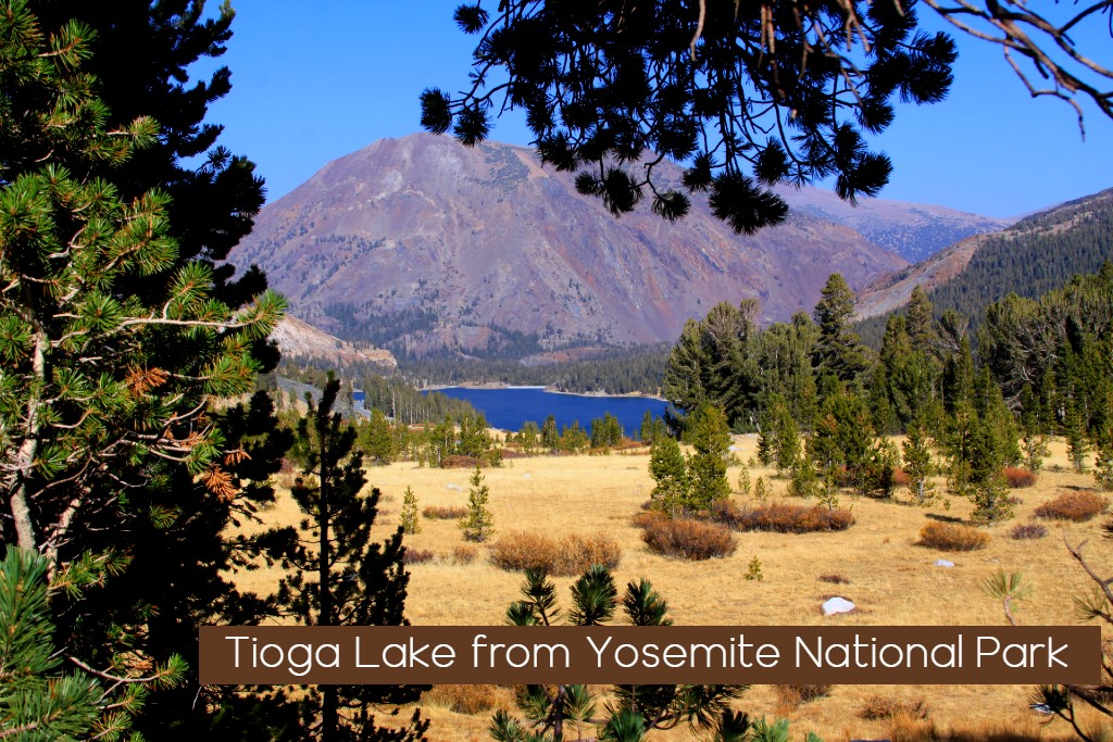
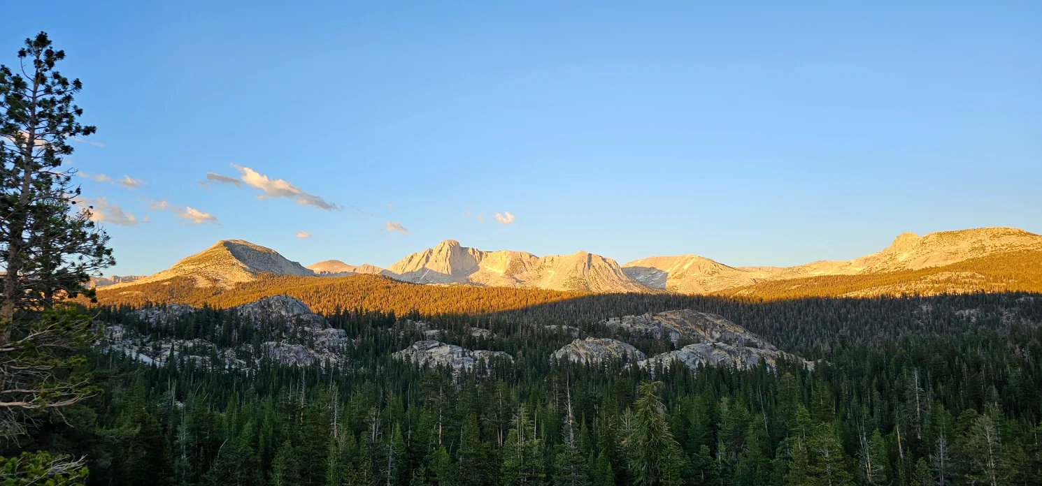
Tioga Pass / HWY 120– Tioga Pass Road is the A-list destination for the Yosemite sightseer who can’t decide what he wants. It’s got some of everything – granite peaks, alpine lakes and meadows, a giant sequoia grove, and even a few hikes to the north rim of Yosemite Valley. The only park entrance on the east side, it is open May through October. Depending on snow conditions, it usually closes in November for the winter and spring.
Glacier Point– If you want to find out whether or not you’re afraid of heights, there’s no more scenic way to do it than to try the hikes off Glacier Point Road. Any of the trails with “Point” in the name lead to jaw-dropping, vertigo-inducing views over the sheer walls of Yosemite Valley. This road also passes the trailhead to Sentinel Dome, where you’ll find a fabulous 360-degree vista and possibly the most revered tree, thanks to Ansel Adams and scores of other photographers, that ever lay dead on the ground.
Hetch Hetchy -Hetch Hetchy Valley has been flooded for more than 80 years, much to the detriment of its own beauty and the environmental cred of the city of San Francisco, which is adamantly opposed to tearing the dam down. Despite the valley’s destruction, there are still things to see here – a giant waterfall that’s had its feet chopped off by the reservoir but is still impressive, and in the Big Oak Flat area, Yosemite’s least crowded giant sequoia grove.

Southern Yosemite / Mariposa – Home to the most renowned bunch of trees in the world. The Mariposa Grove has Giant Sequoias just hanging out in the parking lot that people would normally drive hundreds of miles to see, yet they’re completely overlooked here due to the larger-than-life presences of the Grizzly Giant, the California Tunnel Tree, and a host of others. The wawona region of the park is filled with history, great waterfall hikes and lush meadows. Pace is a little slower here and the crowds are far less than the valley.

Yosemite Wilderness – Untrampled Wilderness. Nearly 95 percent of Yosemite is Congressionally designated Wilderness. Wilderness is a word of many meanings. From a place to be feared to a place to be revered, wilderness can evoke images of wild animals, cascading streams, jagged mountains, vast prairies, or deserts. For individuals wilderness can mean physical challenge, grand vistas, solitude, community, renewal, or respite from a complex technological society. Yosemite Wilderness holds it all.


Yosemite Lodging
Where to Stay in Yosemite National Park
- Lodge / Resorts
- Camping
- Glamping
Yosemite Travel
Centrally located in the Sierra Range Yosemite National Park offers three main access points and transverses the Sierra from West to East. Hwy 140 Hwy Hwy 120 and Hwy 41 are three California Highways that travel into Yosemite. Hwy 120 covers both the Northern Route through to Towns of Groveland and Bucks Meadow as well as gives you the easiest access to Hetch Hetchy. This route is often called the Big Oak Flat entrance. The Big Oak entrance into Yosemite is the most traveled route into Yosemite National Park.
Highway 120 also is the Eastern Route Also known as Tioga Pass. This entrance is seasonal only available summer and fall seasons and is the best entrance for those traveling from reno. Carson city or from Mammoth or Las Vegas. This route will take you through Tuolumne Meadows, the Cathedral range and through the park next to Tenaya Lake on into the El Portal Road entrance just South of Hetch Hetchy.
Highway 140 also Known as the Arch rock Entrance travels from Mariposa and is the fastest route for most people coming from the San Francisco region. They are actually close to the same distance, so this is simply a traffic pattern preference. If you are coming from San Francisco, the fastest route to the park is via the Arch Rock Entrance or the Big Oak Flat Entrance. To enter via Arch Rock Entrance, you will take I-580 east to I-205 east to Highway 140 east into the park. When you enter the park through the Arch Rock Entrance, your road turns into El Portal Road, which leads you to Yosemite Valley.
The Hwy 41 entrance from Wawona rd. entrance. California Highway 41 enters Yosemite National Park at its southern entrance. It leads through the Wawona area, and then through mostly forested areas until it reaches Yosemite Valley. This road is typically open all year, though tire chains may be required anytime outside of summer. This road is where the Tunnel View image is located.
From:
- San Francisco – 4 hours 170 miles
- San Jose 3.5 hours – 165 miles
- Fresno 1.3 hours – 62 miles
- Reno 2.75 hours – 151 miles (Summer route over Tioga Pass)
- Reno 4.5 hours. 230 miles (Winter Route on West side Hwy 120)
- Las Vegas 5.5 hours – 354 miles
- Los Angeles – 4.7 hours – 279 miles (West side of Park
- Los Angeles – 6 Hours – 369 miles
No Content Available

