
Placerville, Calif, April 25, 2023 – The Eldorado National Forest is beginning implementation of their Roadside Hazard
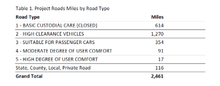
Tree Mitigation Project. This project is designed to reduce safety hazards along the 2,461 miles of National Forest
System (NFS) roads, including 116 miles of state, local, and private roads in Alpine, Amador, El Dorado, and Placer
counties. The project aims to ensure the integrity of the NFS roads and improve safety for the public, Forest Service
staff, firefighters, emergency response personnel, law enforcement, private landowners, contractors, special use permit
holders, and others.
It is important to address the issue of hazardous trees in the aftermath of high-severity wildfires, as they can pose a
significant risk to road users. Trees that have been killed or damaged by a fire, as well as those affected by insects,
disease, drought, or other stressors may become unstable and more likely to fall, particularly in high winds or other
adverse weather conditions. This project’s goal to identify and remove those hazardous trees within striking distance of
roads is a proactive approach to reducing the risk of accidents, injuries, and damage to roads.
The project’s scope is to identify, fell, and remove hazardous trees that are at risk of striking a road within a buffer area
of 200 feet from the edges of NFS maintenance level 1 through level 5 roads, as well as identified state, county, local,
and private roads through NFS lands. However, not all roads within the project area will be treated, and roads within
designated wilderness areas are not included in the project scope.
“The Eldorado National Forest’s Roadside Hazard Tree Mitigation Project was designed to increase the resilience of the
forest to a range of environmental threats, not just wildfires. By removing hazardous trees that could pose a risk to public
safety, and infrastructure, the project aims to reduce the impact of future wildfires and other natural disasters,” said
Forest Supervisor, Joseph Stout.
Treatment of lower maintenance level roads will be based on various factors, including administrative needs, permittee
needs, access needs for utilities, and other uses. The project will use a variety of methods to remove the hazardous trees
within the designated buffer area. These methods may include mechanical removal and piling, hand removal and hand
piling, mastication, towed or in-wood chipping, and pile burning.
The project is conducted in phases, and the first phase will focus on 231 miles of roads within the Caldor Fire footprint.
This phase of the project is expected to last 2 to 3 years, indicating that it is a significant undertaking. It is important to
note that detailed information on each phase of the project will be shared with the public prior to work being started.
