
The Carson Valley is my home base, but it is surprising how few times I have hiked one of its oldest trail segments in town, the Fay Luther trail network. That may speak more about the variety of excellent trails we have to choose from , but it could be that I am always so busy driving elsewhere that I pass up this beautiful trail system.
When I heard early this fall that the Carson Valley Trail association had added a 1.1-mile route to the backside of the Fay network, I knew I needed to get out and see the new features and enjoy a local hike in the High desert below Jobs Peak.
Fay Luther History
According to the Historical Nevada Landmark 118, located just across from the Fay Luther trailhead, Luther Canyon, west of this site, takes its name from Ira M. Luther, who from 1858-1865 had a sawmill there. The house behind the marker across the highway from the trailhead, was his home. In 1861, he was a delegate to the second Nevada Territorial Legislature. After 1865, the canyon came to be known as Horse Thief Canyon because of the “business” of John and Lute Olds, owners of the next ranch south. Besides operating a station along the Emigrant Trail for several years, they rustled horses from emigrants. The animals were sent up the canyon to drift over the ridge into horse thief meadows. After resting and feeding the horses, they were driven down to Woodfords Canyon to sell to other emigrants. A prospector called Sawtooth was allegedly murdered and buried in the barn south of the Luther house. Sam Brown, a notorious bad man, was shot and killed in front of the Olds barn in 1861 by a man he threatened. “Lucky Bill” Thorington, implicated in a murder in California for which he was hanged by vigilantes in 1858, had a ranch two and a half miles to the south.
Fay Luther Trail
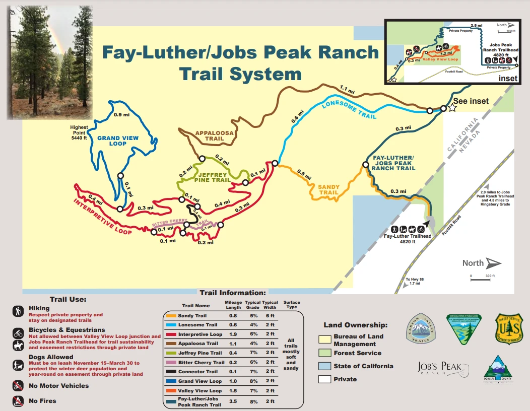
The Easiest way to get to the new Trail is to park at the Fay Luther Trailhead, where the horse parking area is off Foothill Road and Fairview. From there, it is a short .6 mile route to the start of the trailhead on the north side of the trail network. The Trail rises above the Lonesome Trail and stays fairly flat along the hillside, carving into the back and through several canyon draws as it winds about 1.1 miles before reconnecting above the Jeffery Pines Loop on the South side of the trail network.
The Trail is nicely built and easy to walk. The ponderosa trees and manzanita bush along the Trail provide a very intimate yet scenic view that is very relaxing. The Fay Luther Trail Network is 10 miles of trail variety as it travels in various loops along the Desert and Forest floor below Jobs Peak.
All trails are open to mountain bikes and equestrians except for part of the Fay-Luther/Jobs Peak Ranch Trail between Jobs Peak Ranch Trailhead and the Valley View Loop. This section of trail has loose soils, foot bridges and modest terrain challenges. Much of this section is also located on private land which allows hikers only. Mountain biking is difficult on many of these trails because of sandy, loose soils. Horse trailer parking is present at the Fay-Luther Trailhead only.
The trail network now has 10 different trail loops for your enjoyment: The sandy trail (.8 miles), the Lonesome trail (.6 miles), the Interpretive Loop Trail (1.9 miles), The New Appaloosa trail (1.1 miles), The Jeffery Pine trail (.4 mile loop), The Bitter Cherry trail (.2 mile), Connector trail (,1 mile) the Grandview loop (1 mile), the Valley View Loop (1.5 mile) and the Fay Luther /Jobs Peak ranch trail (3.5 miles)

My Afternoon Journey
So, the story of today’s trip for me and Dakota (My 11-year-old brown lab) was one of new adventure and poor assumptions. I had never in all my years taken the route from the Jobs Peak Ranch trailhead, so Friday afternoon at 2:30 pm, I decided to give it a try. (mostly because I read the initial map wrong and thought the Appaloosa trail was another higher connecter of the Ranch trail and Fay Luther trail.)
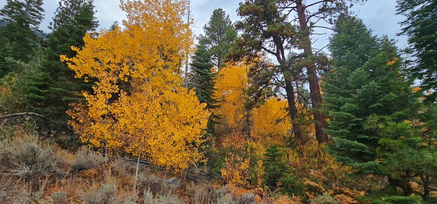
This Jobs Peak Ranch Trail segment is an easement through Private property and climbs up a property line through the desert floor to the beautiful Pine and aspen forest at the base of the mountains. The Trail is in great shape after the week’s recent rains, and we were pleasantly surprised to see fall colors still lingering in the trees once we arrived at the upper section, where it crossed the creek and into the National Wildlife Preserve area. Dakota is not having as much fun at this point because this is a Strict Dog on Leash zone, which she is not used to on our hiking adventures. But the smells of all the wild animals have her nose close to the ground as she pulls me forward.
We make a wrong turn and end at the creek above the bridge, a dead end as a beautiful cascade. In hindsight, on this adventure, I probably should have taken that as a personal clue that I didn’t have all my wits about me today and turned back. Alas, we did not and backtracked 100 yards and found where the Trail turned downhill that we missed.
By this point, I was starting to assume I had made an error on the map and wondered when I would see the Appaloosa trail, considering because of the evening sky looking like rain and getting darker in the November sky it would not be wise to turn back. But, knowing the area, I was not lost and knew there were exit options ahead, so I stayed the course, walking the full 3.5-mile stretch before coming into the Fay Luther Trail network and realizing finally that I had misread the map and was now at the Appaloosa Trail from the far side.
Choices
At this point, it is becoming evident that if I don’t turn back and walk the 1.1-mile Appaloosa trail, I will not make it back to my car before dark. Still, I am local and knowledge that I could exit at Fay Luther and walk back to my car along the highway was still a viable option, so we continued along, enjoying the new trail section created by the association.
The Fay Luther section of this network is open to Horse Travel and Bike Travel, so I kept a close eye on Dakota, finally allowing her to enjoy the trail without a leash for a small bit. At this time of night, it was highly unlikely to see much public life. As we approached the trail’s furthest back point, the rain started to come down and confirmed that I needed to stop lollygagging on the trail network and get started on the walk back to the car.
Coming out of the Appaloosa trail, we hit the Jeffery Pine Trail down to the New to me Sandy trail (which is a huge improvement over the original sandpit trail that I used to take) into the Fay Luther Parking area. Soaked and a bit tired, I cheated and called my kids for a pickup and lift back to the car. Driving from Fay Luther the two-plus miles back to the Ranch parking area, I realized how foolish I probably was as it was plenty dark now, and I was dressed in all dark clothing with the brown dog, probably not the most intelligent way to walk along a road in the rain.

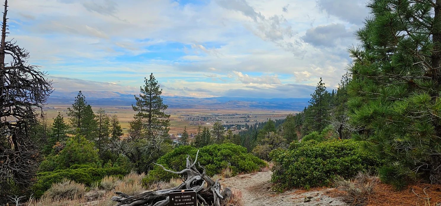
The Views are Spectacular
As I told the story of our trip to my family, I could not help but express my enthusiasm for the new trail and the enjoyment I got from the Views on this afternoon hike. The Jobs Peak Ranch section adds some incredible views along with the additional mileage, and the rainy mood skyline looking East/southeast was right out of an old west cowboy novel.
Cant wait to enjoy this trail system again int he future; just hope that I give myself time next time to enjoy it properly.
Other Carson Valley Trail Experiences
Growing trail Network in the Carson Valley
Take the Carson Valley By trail

