Sierra Rec Magazine’s Beginners Guide to Hiking the Sierra Nevada
If you’re a hiking enthusiast, then the Sierra Nevada Mountains should be at the top of your bucket list. Known for their breathtaking views, diverse ecosystems, and challenging terrains, these mountains offer some of the most captivating trails in the U.S.
While the Pacific Coast Trail, Tahoe Rim Trail and the John Muir Trail are long-standing classics that beckon adventurers from all corners of the globe, the Sierra Nevada Mountains harbor a treasure trove of trails that are equally captivating. These trails, though perhaps lesser-known on the global stage, offer experiences that are nothing short of transformative.
From the gentle whispers of waterfalls to the commanding presence of towering peaks, each trail tells a story of nature’s grandeur. In this article, we’ll journey through ten trails in the Sierra Nevada Mountains that you simply cannot afford to miss. Whether you’re a seasoned hiker or a curious novice, there’s a trail here that’s waiting to be your next adventure.
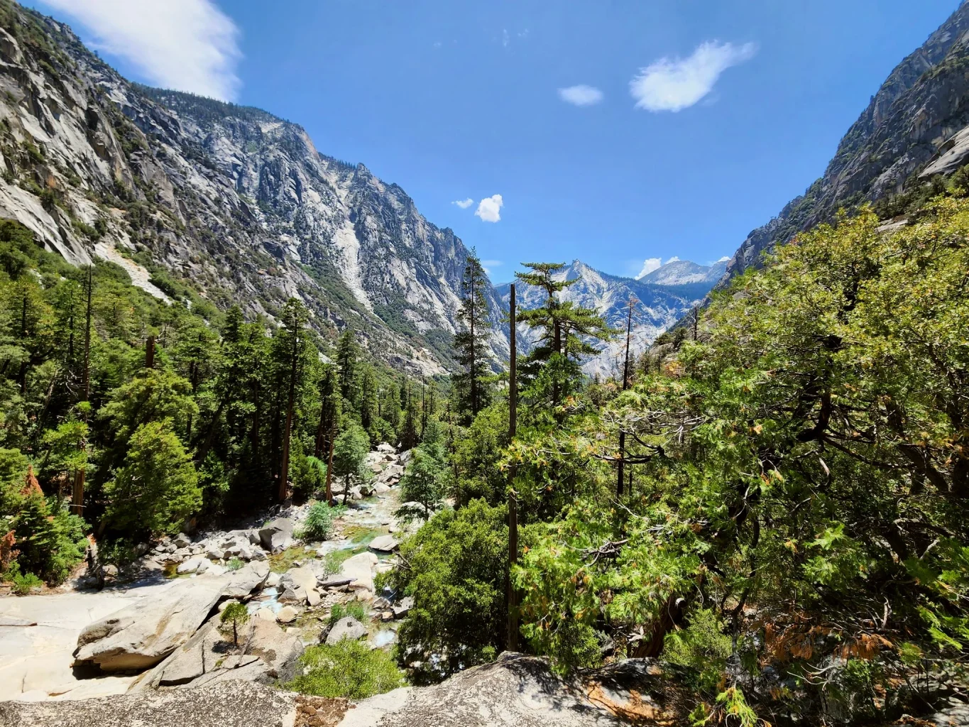
Trail 1: Mist Falls Trail, Kings Canyon National Park
The Mist Falls Trail at Kings Canyon National Park is an incredible hiking experience that should be on every adventurer’s bucket list. It’s a moderately difficult journey, but the stunning views and incredible waterfall at the end of the trail make every step worth it.
- Trail Overview: The Mist Falls Trail is an 8.6-mile round trip hike located near Cedar Grove in Kings Canyon National Park. This trail is best used from May until October and is primarily used for hiking, nature trips, and bird watching.
- Terrain: The trail starts with a gentle slope through a forested area alongside the South Fork Kings River. About halfway through, the trail becomes steeper and more challenging as it climbs up the granite steps to the falls.
- Attractions: The most popular attraction on this trail is, of course, the Mist Falls. This stunning waterfall is one of the largest in the Sierra Nevada and cascades down the mountain in a beautiful misty spray, hence the name.
- Wildlife: Along the way, hikers often spot a variety of wildlife, including black bears, mule deer, and various bird species. Remember to keep a safe distance and never feed or approach wild animals.
- Difficulty Level: This trail is considered moderately difficult. The first part of the trail is quite easy, but the second half of the hike can be strenuous, especially for inexperienced hikers. However, the stunning views and the sight of the falls make the effort worth it.
- Preparation: Hikers should pack plenty of water and snacks, especially in the summer months, as the trail can get quite hot. Proper hiking shoes are also a must due to the rocky terrain close to the falls.
For those seeking a unique and rewarding hiking experience in the Sierra Nevada, the Mist Falls Trail in Kings Canyon National Park is a fantastic choice. With its stunning views, beautiful waterfall, and the chance to see wildlife in their natural habitat, it’s easy to see why this trail is considered a must-see. Remember to respect the natural environment, and happy hiking!
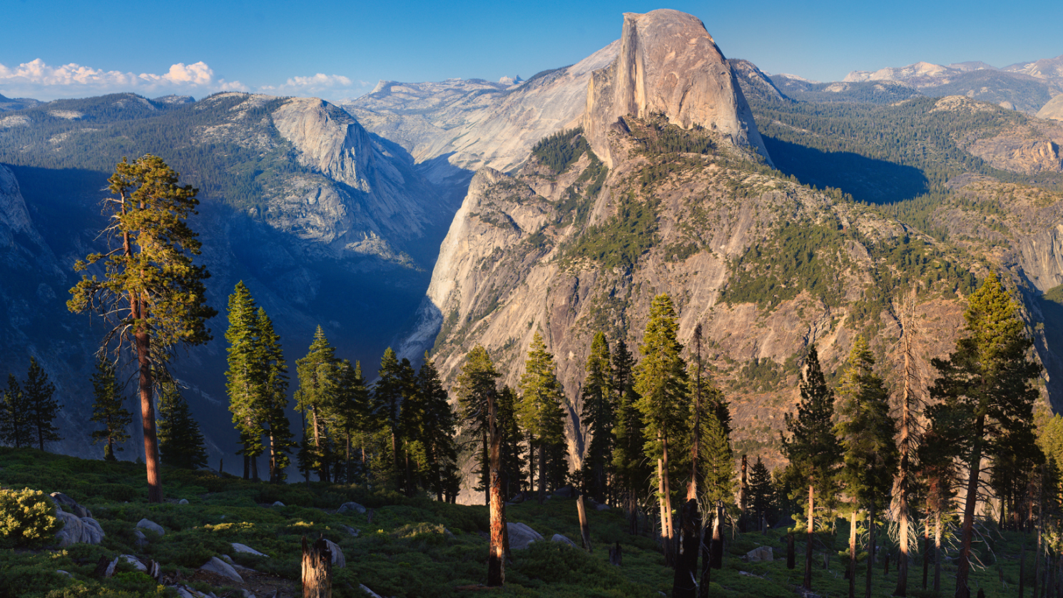
Trail 2: Panorama Trail, Yosemite National Park
One of the most scenic hikes in the Sierra Nevada Mountains is undoubtedly the Panorama Trail in Yosemite National Park. This glorious trail offers just what its name suggests – panoramic views of Yosemite’s most iconic landmarks. Here’s what you need to know about it:
- Location: The Panorama Trail starts at Glacier Point and ends in Yosemite Valley. It is a point-to-point trail, meaning you’ll need to arrange transportation back to your starting point or plan on hiking back.
- Distance: This trail spans roughly 8.5 miles (13.7 km) one way. It’s not a loop, so keep that in mind when planning your hike.
- Difficulty: Considered moderate to strenuous due to its length and elevation changes. Composed mostly of downhill terrain, it can be tough on the knees.
- Highlights: This trail features some of the best views in Yosemite National Park. You’ll pass the Illilouette Fall early on, then proceed to the Panorama Point with unobstructed views of Half Dome, Vernal Fall, and Nevada Fall.
For the adventurous hiker, the Panorama Trail offers an unrivaled experience. Here’s what to expect:
- Illilouette Fall: About two miles into the trail, you’ll encounter the first major attraction – the Illilouette Fall. Spring and early summer are the best times to witness this waterfall in its full glory.
- Panorama Point: This overlook offers a breathtaking view of Half Dome, Vernal Fall, and Nevada Fall. Don’t forget your camera!
- Descending the Mist Trail: The final part of the hike involves descending the Mist Trail, which takes you past the Nevada Fall and Vernal Fall. This section can be slippery due to mist from the falls, so exercise caution.
The Panorama Trail truly lives up to its name, offering awe-inspiring views that will make the strenuous hike worthwhile. Remember to carry plenty of water and snacks, and start early to avoid the afternoon heat. This trail is truly a treasure of the Sierra Nevada and a must-do for any hiking enthusiast.
Trail 3: Mt. Tallac Trail, South Lake Tahoe
If you are looking for a hiking trail that will challenge you physically while offering breathtaking views, Mt. Tallac Trail in South Lake Tahoe is an absolute must-visit. As one of the most rewarding trails in the Sierra Nevada Mountains, it boasts the tallest peak in the Lake Tahoe Basin that provides a panoramic view of Fallen Leaf Lake, Lake Tahoe, and Desolation Wilderness.
Trail Overview
– Distance: Approximately 10 miles round trip
– Elevation Gain: Around 3,250 feet
– Difficulty: Strenuous
– Trail Type: Out and back
– Best Time to Visit: Late spring to early fall
Trail Highlights
Starting Point: The trail begins at the Mt. Tallac Trailhead near Fallen Leaf Lake. The trail starts relatively flat, meandering through a lush forest filled with fragrant pine trees.
Mid-Trail: As you ascend, the trail becomes steeper and rockier, leading you through a series of switchbacks. Don’t forget to turn around and take in the stunning views of Lake Tahoe and Fallen Leaf Lake as you climb.
Summit: The trail ends at the summit of Mt. Tallac, standing at over 9,700 feet. Here, you will be rewarded with a 360-degree view of the surrounding Sierra Nevada Mountains, Lake Tahoe, and the vast expanse of Desolation Wilderness.
Pro Tips
– Make sure to carry plenty of water and snacks. The trail is strenuous, and you will need to replenish your energy along the way.
– Start your hike early. The trail can take 6-8 hours to complete, depending on your pace.
– Wear sturdy hiking boots. The terrain can be rocky and uneven, particularly in the upper sections of the trail.
– Don’t forget your camera. The panoramic views from the summit are truly breathtaking and definitely worth capturing.
In short, Mt. Tallac Trail offers a challenging yet rewarding hiking experience. With its awe-inspiring views and diverse terrain, it’s no wonder this trail ranks among the top hiking trails in the Sierra Nevada Mountains. Whether you’re a seasoned hiker seeking a new adventure or a nature lover wanting to immerse in the beauty of the great outdoors, the Mt. Tallac Trail won’t disappoint.
Trail 4: Kennedy Lake Trail – Emigrant Wilderness
Nestled within the Emigrant Wilderness, the Kennedy Lake Trail offers hikers a serene escape into the heart of the Sierra Nevada Mountains. This trail is a hidden gem, providing a blend of alpine meadows, dense forests, and the stunning Kennedy Lake as its centerpiece.
Trail Overview:
- Distance: The trail spans approximately 8 miles one-way, making it a 16-mile round trip.
- Difficulty: Moderate, with some steep sections that can be challenging for novice hikers.
- Trail Type: Out and back.
- Best Time to Visit: Late spring to early fall, when the trail is free of snow and offers the best conditions for hiking.
Trail Highlights:
- Kennedy Meadows: Early in the hike, you’ll pass through the lush Kennedy Meadows, a vast expanse of greenery that’s perfect for picnicking and relaxation.
- River Crossings: The trail follows the Kennedy Creek, offering multiple river crossings that add a touch of adventure to the hike.
- Kennedy Lake: The trail culminates at the pristine Kennedy Lake, surrounded by towering peaks and offering a perfect spot for camping or fishing.
Wildlife and Flora:
- The trail is home to various wildlife species, including mule deer, black bears, and a plethora of bird species.
- As you hike, you’ll traverse through dense forests of pine and fir, and during the spring and early summer, the meadows burst into color with wildflowers.
Tips for Hiking the Kennedy Lake Trail:
- Preparation: Ensure you have a map and compass, as some sections of the trail can be a bit tricky to navigate.
- Camping: If you plan to camp at Kennedy Lake, remember to get a wilderness permit. The area around the lake offers several ideal spots for setting up camp.
- Fishing: Kennedy Lake is known for its trout population, so if you’re an angling enthusiast, don’t forget your fishing gear.
In short, the Kennedy Lake Trail in the Emigrant Wilderness is a delightful journey into the heart of the Sierra Nevada Mountains. With its varied landscapes, abundant wildlife, and the serene Kennedy Lake, this trail is a must-visit for anyone looking to experience the true essence of the Sierra Nevada.

Trail 5: Rubicon Trail, Lake Tahoe
Looking for an unforgettable hiking experience in the Sierra Nevada Mountains? The Rubicon Trail in Lake Tahoe is a must-visit. This trail offers an unrivalled journey through some of the most beautiful wilderness areas in California.
- Location: The Rubicon Trail is located in the D.L. Bliss State Park and Emerald Bay State Park on the west shore of Lake Tahoe.
- Trail Length: This is a moderately challenging 16.4-mile round-trip trail that typically takes around 6-7 hours to complete.
- Scenic Highlights:
– Stunning views of Lake Tahoe’s tranquil, azure waters
– The historic Rubicon Point Lighthouse
– The opportunity to explore the picturesque Emerald Bay and Fannette Island
– Unique geological formations along the trail
- Terrain: The terrain of the Rubicon Trail is a mix of dirt path, rocky slopes, and forested areas. The trail traverses the cliffs over Lake Tahoe, providing breathtaking panoramic views.
- Wildlife: The trail’s diverse ecosystem is home to a variety of wildlife, including black bears, mule deer, and a broad array of bird species.
- Difficulty Level: This trail is rated as moderate. The path is well-marked, but there are some steep sections and rocky areas that can be challenging. It’s recommended for hikers with some experience.
- Best Time to Hike: The best time to hike the Rubicon Trail is between May and October when the weather is most favorable. However, it’s worth noting that the trail can be busy during the summer months, particularly on weekends.
Special Tips:
– Make sure to carry plenty of water and sunscreen as the trail has long stretches exposed to the sun.
– Keep a safe distance from wildlife and do not feed animals.
– As always, remember to pack out what you pack in to help preserve the beauty of this trail for future generations.
The Rubicon Trail guarantees a unique hiking experience with unforgettable vistas, diverse wildlife, and the exquisite beauty of Lake Tahoe’s surroundings. Make sure it’s on your list when you visit the Sierra Nevada Mountains!

Trail 6: Sierra Buttes Trail – Tahoe National Forest
The Sierra Buttes Trail, located within the expansive Tahoe National Forest, is a testament to the rugged beauty and grandeur of the Sierra Nevada Mountains. This trail, while challenging, rewards hikers with unparalleled panoramic views and a close encounter with the iconic Sierra Buttes Fire Lookout.
Trail Overview:
- Distance: The trail is approximately 5 miles round trip.
- Difficulty: Considered moderate to strenuous due to its steep inclines and high elevation.
- Trail Type: Out and back.
- Best Time to Visit: Late spring through early fall, when the trail is most accessible and free from snow.
Trail Highlights:
- Elevated Views: As you ascend, you’ll be treated to ever-expanding views of the surrounding lakes, forests, and distant mountain ranges.
- Sierra Buttes Fire Lookout: One of the trail’s main attractions, this historic fire lookout stands at an elevation of over 8,500 feet. The final climb to the lookout involves a series of staircases that cling to the side of the butte, making for an exhilarating ascent.
- Lakes and Reservoirs: The trail offers views of the serene Upper and Lower Sardine Lakes, as well as the Sand Pond.
Wildlife and Flora:
- The trail is home to diverse wildlife, including mule deer, mountain goats, and various bird species.
- The flora is equally diverse, with sections of dense forest giving way to open meadows dotted with wildflowers, especially during the spring and early summer months.
Tips for Hiking the Sierra Buttes Trail:
- Preparation: The high elevation and steep sections can be challenging. Ensure you’re acclimatized to the altitude and have sturdy hiking boots.
- Fire Lookout Access: The Sierra Buttes Fire Lookout is generally accessible, but it’s a good idea to check in advance if it’s open to the public during your visit.
- Weather: The weather can be unpredictable at higher elevations. Always check the forecast before heading out and pack accordingly.
- Safety: The final ascent to the lookout can be daunting for those with a fear of heights. Always proceed with caution and at your own comfort level.
In summary, the Sierra Buttes Trail in Tahoe National Forest offers a blend of adventure, history, and breathtaking natural beauty. The trail’s challenging nature is more than compensated for by the awe-inspiring views and the unique experience of visiting the Sierra Buttes Fire Lookout. For those seeking a memorable hiking experience in the Sierra Nevada, this trail is a top contender.

Trail 7: Rae Lakes Loop, Kings Canyon National Park
If you’re seeking a multi-day hike that offers breathtaking alpine scenery, challenging terrain, and a sense of true wilderness adventure, then the Rae Lakes Loop trail is a must-visit on your next trip to the Sierra Nevada Mountains. Situated in Kings Canyon National Park, this trail is a popular backpacking route and is renowned for its stunning alpine lakes and towering granite peaks.
Distance and Difficulty
The Rae Lakes Loop spans approximately 41.4 miles and is considered a strenuous hike due to its length and elevation gain. It’s recommended for experienced hikers who are in good physical condition. The trail steadily gains altitude from the trailhead at Roads End in Kings Canyon, reaching a maximum elevation of over 11,978 feet at Glen Pass.
Trail Highlights: The trail offers a variety of scenic vistas, including:
- The beautiful alpine Rae Lakes, a series of serene, crystal-clear bodies of water surrounded by majestic peaks.
- Glen Pass, the highest point on the trail, offers panoramic views of the surrounding mountain ranges.
- The trail also passes through Paradise Valley, which lives up to its name with lush meadows, roaring waterfalls, and towering cliffs.
Wildlife
Expect to encounter a variety of wildlife, including mule deer, black bears, and a diverse array of bird species. Remember to store your food properly to avoid attracting bears to your campsite.
Permits and Best Time to Hike
Due to the trail’s popularity, a wilderness permit is required for overnight camping, and it’s recommended to reserve one well in advance. The best time to hike the Rae Lakes Loop is from late June through early October when the trail is usually free of snow.
The Rae Lakes Loop is a demanding but rewarding hike that showcases some of the best natural beauty that the Sierra Nevada Mountains have to offer. Whether you’re drawn to the tranquil alpine lakes, the dramatic mountain vistas, or the challenging hiking experience, Rae Lakes Loop has something for every outdoor enthusiast.
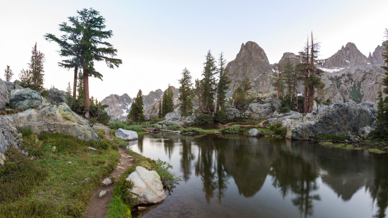
Trail 8: Minaret Lake Trail, Mammoth Lakes
Nestled in the heart of the Sierra Nevada Mountains, the Minaret Lake Trail is an absolute must for any hiker. This trail in Mammoth Lakes not only offers a breathtaking view of the Minaret Range, but it also borders the Ansel Adams Wilderness, making it a truly unique experience. The trail extends for about 7 miles, leading you through some of the most incredible landscapes in the area.
Elevation and Difficulty:
– The trail starts at an elevation of 7,560 feet and climbs to a towering 9,850 feet. This dramatic increase in elevation makes the Minaret Lake Trail a moderate to strenuous hike.
– The trail’s difficulty level is also affected by the rocky terrain. Hikers must be well-prepared with sturdy boots and walking poles.
Trail Highlights:
– The trail kicks off at Devil’s Postpile National Monument, a fascinating geological formation that is worth a visit in its own right.
– As you ascend, you’ll pass through a lush forest of red fir and lodgepole pine, before the landscape transitions into an alpine environment with sparse vegetation.
– One of the main highlights of the Minaret Lake Trail is the mesmerizing views of the Minarets, a series of jagged peaks that tower over the landscape.
– The trail culminates at the stunning Minaret Lake, a crystal-clear body of water that perfectly mirrors the towering peaks surrounding it.
Wildlife and Flora:
– The Minaret Lake Trail is home to a plethora of wildlife. Keep your eyes peeled for mule deer, black bears, and a variety of bird species.
– The trail boasts an array of flora, from vibrant wildflowers to towering pine trees. The changing seasons offer a colorful display of nature’s beauty, from the lush greens of summer to the fiery reds and oranges of autumn.
Tips for Hiking the Minaret Lake Trail:
– Make sure to bring plenty of water and snacks. The hike can take up to 5-6 hours, depending on your pace.
– The trail is best hiked from July until October when the trail is free from snow and the weather is generally good.
– Remember to pack a camera. The stunning views offered by the Minaret Lake Trail are something you’ll want to capture and remember.
So, for those seeking an adventure with incredible views and a touch of challenge, the Minaret Lake Trail is definitely one of the Sierra Nevada trails you can’t miss.

Trail 9: Eagle Lake Trail, South Lake Tahoe
Nestled in the heart of South Lake Tahoe, the Eagle Lake Trail offers a breathtaking hiking experience that is sure to leave you spellbound. This trail is a must-visit for any hiking enthusiast exploring the Sierra Nevada Mountains.
Trail Overview:
The Eagle Lake Trail is a moderately challenging hike that spans approximately 2 miles round trip, making it a great option for both experienced hikers and beginners. The trail begins at the Eagle Falls Trailhead and winds through lush forests of pine and fir, leading you to the serene Eagle Lake.
Highlights of the Eagle Lake Trail:
– Stunning Waterfalls: One of the main attractions of this trail is the Eagle Falls, an impressive waterfall that cascades into Emerald Bay. The roaring sound of the falls and the misty spray offer a refreshing start to your hike.
– Eagle Lake: The trail culminates at Eagle Lake, a beautifully secluded alpine lake surrounded by towering peaks. Here, you can enjoy a peaceful picnic while soaking up the stunning views.
– Flora and Fauna: The trail is home to a diverse range of plant and wildlife species. Keep an eye out for mule deer, black bears, and a variety of bird species.
Hiking Experience:
The trail offers a moderate hike with a steady ascent that can be completed in a few hours. It’s well-marked, but the rocky terrain can be challenging, so hiking boots are recommended. You’ll be rewarded with panoramic views of the Sierra Nevada Mountains and the shimmering Eagle Lake. Remember, the trail can get busy during the summer months, so plan an early start to enjoy the serene beauty in solitude.
Quick Tips for Eagle Lake Trail:
– The trail is best hiked from May through October.
– Dogs are allowed, but must be kept on a leash.
– A US Forest Service parking permit is required at the Eagle Falls Trailhead.
– Remember to pack plenty of water and snacks for the hike.
Eagle Lake Trail, with its stunning waterfalls, tranquil lake, and breathtaking mountain views, is undoubtedly a hike that you can’t miss when exploring the Sierra Nevada Mountains. Plan your visit and get ready to be captivated by its natural beauty.

Trail 10: Big Pine Lakes Trail, Inyo National Forest
Nestled in the heart of the Inyo National Forest, the Big Pine Lakes Trail is a must-visit for any hiking enthusiast. This trail offers an incredible blend of natural beauty, including alpine lakes, towering peaks, and even the chance to see a glacier. With a total length of approximately 14 miles, it can be completed as a day hike but is best enjoyed as a 2-3 day backpacking trip.
– Trail Overview: The Big Pine Lakes Trail begins in the North Fork Big Pine Creek Trailhead, which is about 10 miles west of the town of Big Pine. The trail is a loop with a moderate difficulty level, making it accessible for hikers with a range of experience levels.
– Scenic Highlights: As you traverse this trail, you’ll have the opportunity to see a series of stunningly blue glacially-fed lakes. The trail also offers breathtaking views of the Palisade Glacier, the southernmost glacier in the United States.
– Wildlife: The Big Pine Lakes Trail is home to a variety of wildlife. You might see black bears, mule deer, and an extensive array of bird species.
– Camping Options: There are several great camping spots along the trail. The areas around Second Lake and Third Lake are particularly popular for their stunning views. Remember, wilderness permits are required for overnight stays in this area.
– Seasonality: The trail is typically snow-free and best for hiking from June to October. Do note that weather conditions can change rapidly in the Sierra Nevada, so it’s always essential to check the forecast before setting out.
– Preparation: As with any hike in the Sierra Nevada, make sure to pack plenty of water, high-energy snacks, and sun protection. The altitude can be challenging for some, so acclimatization and pacing are crucial.
The Big Pine Lakes Trail offers a taste of the Sierra Nevada’s diverse landscapes and is sure to leave you with lasting memories. Whether you’re new to hiking or an experienced backpacker, this trail provides a rewarding adventure in one of the most scenic corners of the Inyo National Forest.

