

Navigating the Sierra Nevada Shoulder Season
The snow line is retreating, waterfalls are thundering at their peak volume, and the high country remains locked in winter’s grip. This is spring in the Sierra Nevada: a season of contradictions that rewards hikers willing to work within its constraints. Finding the best spring wilderness hikes in the Sierra requires understanding that May and early June operate by different rules than summer. Trails that would be straightforward in August become adventures in route-finding, stream crossings, and reading snowpack conditions.
I’ve spent years timing trips to catch that narrow window when wildflowers carpet the lower elevations while snow still blankets the passes. The sweet spot exists, but it shifts every year depending on winter snowfall and spring temperatures. A light snow year might open trails by mid-April. A heavy one can keep popular routes snowbound into July.
What makes spring hiking in the Sierra genuinely special isn’t just the dramatic waterfalls or the absence of summer crowds. It’s the rawness of the landscape: rivers running brown with sediment, meadows saturated and spongy underfoot, the smell of wet granite and pine. You’re seeing the mountains in a transitional state that most visitors never witness.
The trade-off is uncertainty. You’ll need backup plans, flexible itineraries, and a willingness to turn around when conditions demand it. But for those who embrace the challenge, spring offers some of the most memorable wilderness experiences these mountains provide. Sierra Rec Magazine has documented dozens of these shoulder-season routes, and the seven hikes below represent the most rewarding options when the calendar reads May.
Lower Elevation Trailheads for Early Season Access
Elevation dictates everything during spring. While the 9,000-foot trailheads remain buried, the western slope canyons and eastern escarpment offer accessible terrain. The general rule: for every 1,000 feet of elevation gain, expect snow to linger roughly two weeks longer.
Trailheads below 5,000 feet on the west side typically clear by April. This includes access points for the Kern River Canyon, Hetch Hetchy, and the lower reaches of the Merced River drainage. Eastern Sierra trailheads present a different picture: despite lower precipitation, cold temperatures preserve snowpack longer. However, the rain shadow effect means trails around Lone Pine and Bishop often melt out faster than their elevation would suggest.
The key is checking current conditions rather than relying on historical averages. Call ranger stations directly. They’ll tell you exactly where the snow line sits and which creek crossings are running dangerously high. The Sierra Avalanche Center’s snowpack data also provides useful context, even for hikers not traveling in avalanche terrain.
Obtaining Overnight Wilderness Permits for May
Permit systems in the Sierra operate differently during shoulder season. Many quotas don’t kick in until Memorial Day weekend, which means May offers a rare opportunity for spontaneous backcountry trips. The Inyo National Forest, which manages much of the Eastern Sierra, runs on a quota system from May 1st, but competition remains far lighter than summer months.
Yosemite wilderness permits follow a different calendar. The park requires permits year-round, though walk-up availability increases dramatically in spring. The wilderness center in Yosemite Valley opens daily, and I’ve rarely been turned away in May for popular routes that would require months of advance planning by July.
For Ansel Adams Wilderness, permits come through the Sierra National Forest or Inyo National Forest depending on your entry point. The Agnew Meadows trailhead, accessible once Highway 203 opens past Mammoth, typically sees quota enforcement begin mid-June. Before that date, self-registration at the trailhead suffices.
One critical note: even when quotas aren’t in effect, you still need a permit for overnight travel. The self-issue stations at trailheads handle this, but don’t skip the step. Rangers do check, and the permit system provides valuable data for wilderness management.
Top 7 Spring Wilderness Hikes
Hetch Hetchy to Rancheria Falls
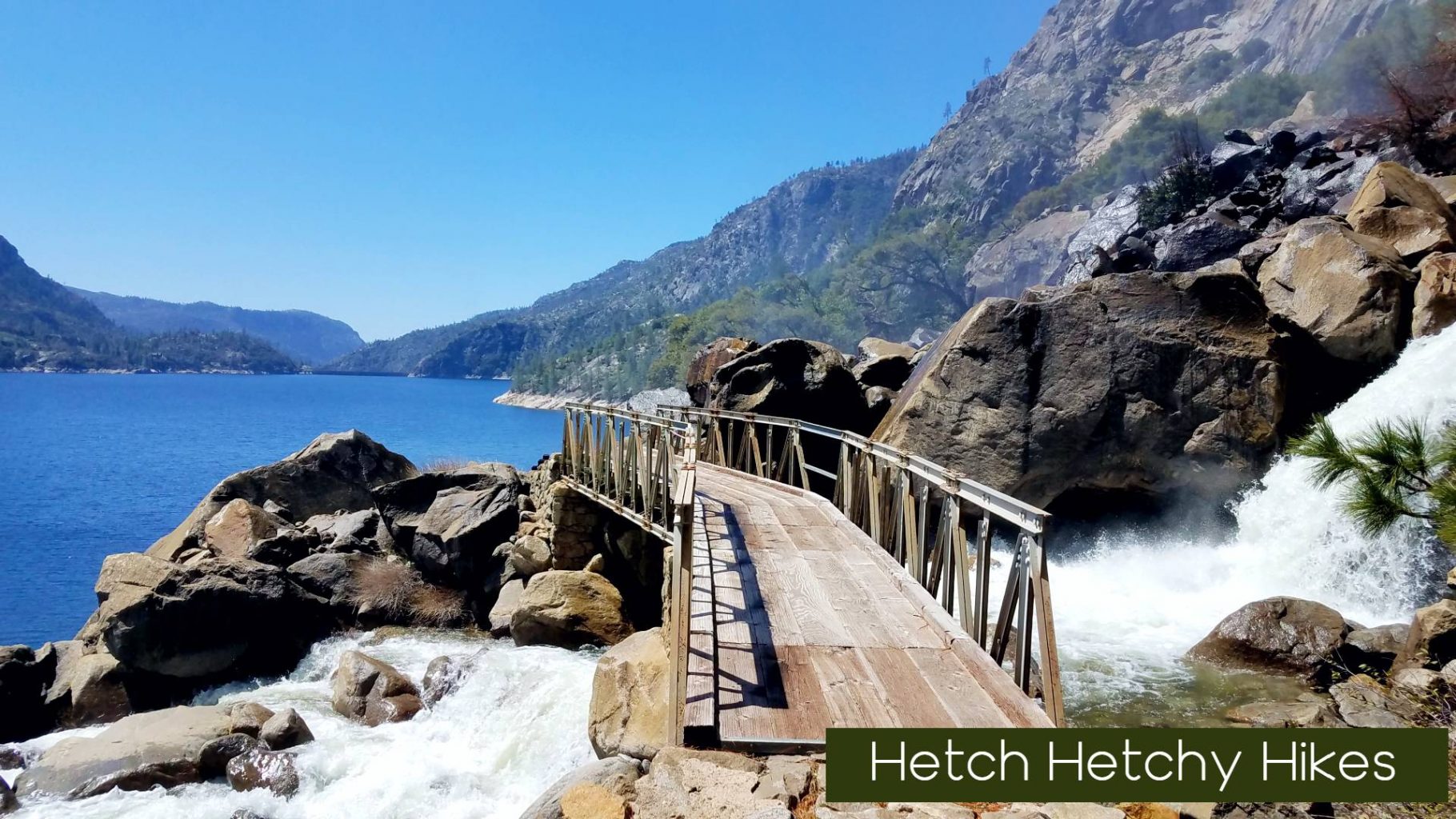
This 13-mile round trip showcases why spring transforms ordinary hikes into extraordinary ones. Rancheria Falls, a modest cascade by August, becomes a 1,600-foot staircase of whitewater in May. The trailhead sits at just 3,800 feet, making it accessible when higher Yosemite routes remain snowbound.
The trail follows the north shore of Hetch Hetchy Reservoir, passing through oak woodlands and granite slabs before climbing gently to the falls. Spring brings two bonuses: Wapama Falls, passed at mile 2.5, runs so heavy that the footbridge crossing often closes due to dangerous spray and flooding. Check conditions before departing, as this can halt your progress entirely.
Backpackers can continue to Rancheria Falls camp, one of the most scenic designated sites in Yosemite’s wilderness. The falls create a constant roar that drowns out any other sound, and the mist keeps the surrounding vegetation lush and green. Permits are required but easily obtained in May through Yosemite’s wilderness reservation system.
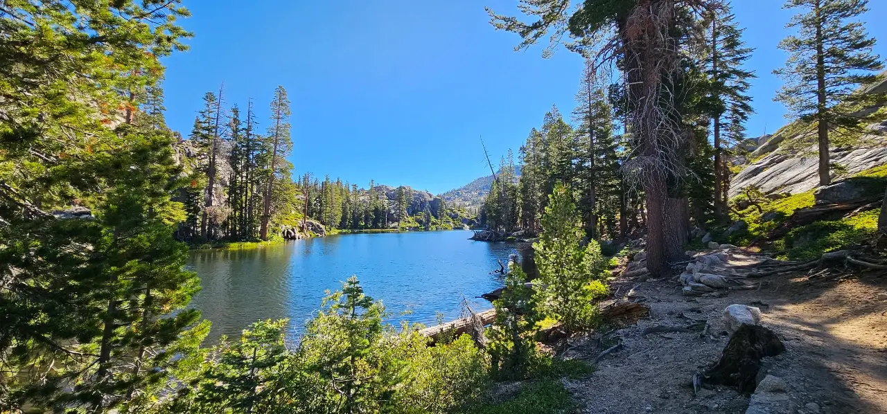
Agnew Meadows and the Shadow Lake Loop

When Highway 203 opens past Mammoth Mountain, typically late May, the Shadow Lake Loop becomes one of the finest day hikes in the Eastern Sierra. The 7.5-mile circuit visits Shadow Lake, a granite-rimmed pool beneath the Minarets, and returns through flower-filled meadows.
Timing matters here. Too early, and the trail crosses snow patches that obscure the route. Too late, and you’ll share the path with dozens of other hikers. The window between snowmelt and summer crowds usually spans about three weeks in June.
The trail gains 1,500 feet from Agnew Meadows to Shadow Lake, passing through red fir forest before emerging at the lake’s outlet. The Minarets rise directly above the far shore, their spires often still holding snow into July. This is classic Ansel Adams Wilderness: the terrain that inspired the photographer’s most iconic Sierra work.
Middle Fork Kaweah River to Panther Gap

Sequoia’s foothill trails don’t get the attention they deserve in spring, and that’s exactly why they shine. Starting near the Middle Fork of the Kaweah River, this route climbs steadily toward Panther Gap, offering a front-row seat to the seasonal transition from foothills to high country.
Early in the hike, the river runs loud and fast, fed by melting snow from above. The trail winds through oak and chaparral before gradually shifting into mixed conifer forest as you gain elevation. Spring wildflowers line the lower sections, while higher up, lingering snow patches remind you how close the high Sierra still is.
At roughly 7-8 miles round trip depending on your turnaround point, this hike is more about the journey than a single destination. Panther Gap itself offers wide-open views toward the Great Western Divide-a preview of the terrain that will open fully in just a few more weeks.
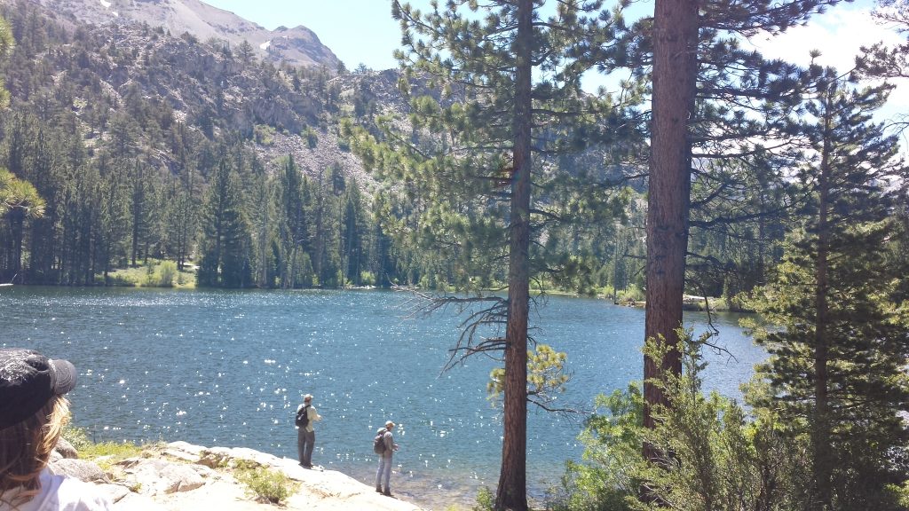
Cottonwood Lakes Basin

On the far southern edge of the Sierra, Cottonwood Lakes offers one of the earliest accessible high-elevation experiences-though “early” here still depends heavily on snowpack. In lighter snow years, the trailhead near 10,000 feet can open by late spring, unlocking a rare chance to step into alpine terrain before summer.
The hike into Cottonwood Lakes is a gradual 5-mile climb through open forest and wide meadows, eventually reaching a basin dotted with clear, cold lakes beneath Mount Langley. In spring, patches of snow often linger along the trail, and the lakes themselves may still be partially frozen.
What makes this area special is the sense of space. The terrain opens wide, the peaks feel close, and even early in the season, you can find quiet corners away from other hikers. It’s a place where winter and summer overlap-where you might walk on dry trail one mile and snow the next.
Emigrant Wilderness: Crabtree to Camp Lake
Just north of Yosemite, Emigrant Wilderness often flies under the radar-but in spring, that works in your favor. Starting from the Crabtree Trailhead, this route offers one of the most reliable early-season access points into granite basins and alpine lakes.
The trail rolls gently through pine forest before opening into meadows and granite outcroppings, eventually reaching Camp Lake at around 6 miles round trip. In spring, streams run full, meadows turn green, and the crowds remain light compared to neighboring Yosemite.
Camp Lake sits in a quiet granite bowl, often with patches of snow lingering along the shaded edges. For those willing to explore a bit farther, nearby lakes and off-trail routes open up additional solitude. This is classic Sierra terrain without the pressure-an ideal place to ease into the backpacking season.
Echo Lake to Lake of the Woods (Desolation Wilderness)

Desolation Wilderness doesn’t typically come to mind for spring hiking, but the lower western edge near Echo Lake offers one of the earliest access points into this granite landscape. Before the high basins melt out, this route gives you a quiet window into Desolation’s character-without the peak-season crowds.
Starting from Echo Lake, the trail climbs steadily through forest and exposed granite, weaving past small creeks fed by early snowmelt. The air still carries a hint of winter here, especially in shaded sections, but the south-facing slopes begin to open quickly as the season progresses. You’ll likely encounter a mix of dry trail and lingering snow patches, especially as you approach Lake of the Woods.
At roughly 4-5 miles round trip depending on conditions and turnaround, this is less about distance and more about timing. Catch it right, and you’ll have a quiet Desolation experience that feels a step ahead of the season-granite slabs warming in the sun, light reflecting off partially thawed water, and just enough solitude to remind you why this wilderness is so special later in the year.
Permits are required for overnight travel, though early season conditions often mean lighter demand. Always check snow levels and trail conditions before heading out, as Desolation can hold snow longer than expected.
The Kern River Canyon via Black Rock
The southern Sierra sees far less traffic than its northern counterparts, and the Kern River Canyon exemplifies why this region deserves attention. The Black Rock trailhead accesses a stretch of the Kern that feels genuinely remote: no day hikers, no crowds, just river and canyon.
Spring brings the Kern to life. The river runs big and fast, colored turquoise where it pools and white where it drops through boulder gardens. The trail traverses the western canyon wall, offering aerial views of the water below. At 4,200 feet elevation, snow rarely poses problems, though spring storms can make the dirt access road temporarily impassable.
The route covers 8 miles one-way to the Johnsondale Bridge, making it ideal for a shuttle hike or a leisurely out-and-back to the halfway point. Riverside camps exist throughout the canyon, though permit requirements through Sequoia National Forest apply for overnight stays.
Bonus Hike
Hoover Wilderness: Secret, Roosevelt, and Lane Lake Loop
For those looking to step a little farther off the radar, the Hoover Wilderness delivers one of the most rewarding early-season loops in the Sierra. The route linking Secret Lake, Roosevelt Lake, and Lane Lake offers a blend of solitude, open terrain, and classic Eastern Sierra views-without the traffic of more well-known trail systems.
Starting from the Twin Lakes area near Bridgeport, the trail climbs steadily into a mix of sagebrush, open forest, and granite benches. Spring arrives here in layers. Lower elevations dry out early, while higher sections may still hold snow, especially around north-facing slopes and shaded basins.
The loop itself varies depending on your exact route, but generally covers 10-12 miles with moderate elevation gain. Secret Lake lives up to its name-quiet, tucked away, and often overlooked. Roosevelt Lake sits in a broader basin with expansive views, while Lane Lake offers a more intimate setting, often framed by lingering snowfields well into early summer.
What makes this loop stand out in spring is the sense of transition. You move through multiple elevations and ecosystems in a single trip, watching the Sierra wake up as you go. Creeks run high, the air stays crisp, and campsites remain uncrowded.
Permits are required through the Humboldt-Toiyabe National Forest, though availability is typically much better than peak summer months. As always in spring, route-finding and conditions can change quickly-come prepared for a mix of trail, snow, and shifting weather.
Choosing Your Terrain: Yosemite vs. Ansel Adams Wilderness
Infrastructure and Accessibility Differences
Yosemite’s wilderness comes with infrastructure that the Ansel Adams Wilderness lacks. Established trails receive regular maintenance, footbridges span major creek crossings, and ranger stations provide current conditions. This support system makes spring hiking more predictable, if less adventurous.
The Ansel Adams Wilderness, managed by the Sierra and Inyo National Forests, operates with a lighter touch. Trails receive less frequent maintenance, creek crossings often lack bridges, and you’re more likely to encounter downed trees and obscured tread. Spring amplifies these differences: the same snowmelt that creates spectacular waterfalls also washes out trail sections and makes route-finding challenging.
For hikers new to spring Sierra conditions, Yosemite’s better-maintained trails offer a gentler introduction. Those seeking solitude and willing to navigate uncertainty will find the Ansel Adams Wilderness more rewarding.
Permit Quotas and Solitude Expectations
Yosemite’s permit system, even in spring, channels hikers toward specific trailheads and limits numbers. The result is predictable: you’ll encounter other backpackers, though far fewer than summer. Popular routes like the High Sierra Camps loop or the Mist Trail corridor see steady traffic whenever conditions allow access.
The Ansel Adams Wilderness distributes visitors across a much larger area with less restrictive quotas. Enter from Agnew Meadows in May, and you might hike for hours without seeing another person. The trailheads around Edison Lake and Florence Lake, accessible once the roads open, offer even greater solitude.
Spring wilderness hikes in the Sierra reward those who venture beyond the obvious destinations. The backcountry doesn’t require a famous name to deliver stunning scenery, and the less-traveled routes often provide the most memorable experiences.
Critical Safety for Peak Snowmelt Conditions
Managing River Crossing Risks
More hikers die from drowning than any other cause in the Sierra Nevada. Spring snowmelt transforms gentle creeks into dangerous torrents, and the cold water temperature makes even brief immersion potentially fatal. Understanding river crossing safety during spring snowmelt isn’t optional: it’s essential.
Scout crossings before committing. Look for wide, shallow sections rather than narrow channels where water runs deep and fast. Unbuckle your pack’s hip belt so you can jettison it if you fall. Use trekking poles for stability, facing upstream and moving diagonally with the current.
The safest strategy is often patience. Water levels drop significantly between afternoon and early morning as overnight freezing slows snowmelt. A crossing that’s dangerous at 4 PM might be manageable at 7 AM. Plan your itinerary around this reality, camping on the correct side of major crossings when possible.
Identifying Snow Bridges and Post-holing Hazards
Spring snow presents different challenges than winter snowpack. The freeze-thaw cycle creates a hard crust that supports weight in the morning but collapses by afternoon. Post-holing: breaking through the surface and sinking thigh-deep: turns a simple traverse into an exhausting ordeal.
Start early. The window between first light and late morning offers the firmest snow conditions. By noon, south-facing slopes become unreliable, and even north-facing aspects soften enough to make travel difficult.
Snow bridges over creeks and gullies pose particular danger. These remnants of winter snowpack often look solid but may have hollow cavities beneath. Probe with trekking poles before crossing, and never assume a bridge that held yesterday will hold today.
Essential Gear for Variable Spring Weather
Spring in the Sierra can deliver all four seasons in a single day. Morning frost gives way to warm sunshine, followed by afternoon thunderstorms and evening chill. Your gear list needs to accommodate this variability without becoming unmanageably heavy.
Layering systems work better than single heavy garments. A lightweight base layer, insulating mid-layer, and waterproof shell covers most conditions. Add a puffy jacket for camp warmth and you’re prepared for temperatures ranging from the 20s to the 70s.
Footwear decisions depend on expected snow travel. Trail runners work fine for lower elevation routes, but anything involving significant snowpack warrants boots and possibly microspikes or crampons. Gaiters keep snow out of your footwear during post-holing and add warmth during stream crossings.
Other spring essentials include sun protection (snow reflection intensifies UV exposure), a reliable water filter (snowmelt streams run everywhere but may carry sediment), and navigation tools beyond your phone. GPS apps work well, but batteries drain fast in cold conditions, and a paper map with compass provides crucial backup.
The best spring wilderness hikes in the Sierra demand respect for changing conditions and reward preparation with experiences unavailable during the crowded summer months. Whether you choose the dramatic waterfalls of Hetch Hetchy, the remote canyon of the Kern, or the alpine beauty of Shadow Lake, May offers a window into the Sierra’s most dynamic season.
For more in-depth guides to Sierra Nevada adventures, Sierra Rec Magazine publishes free digital content covering trails, permits, and seasonal conditions across the range. Subscribe here to stay informed about the routes and timing that make mountain travel rewarding.
