Multi Use Trail System in South Lake Tahoe Region Growing in Popularity
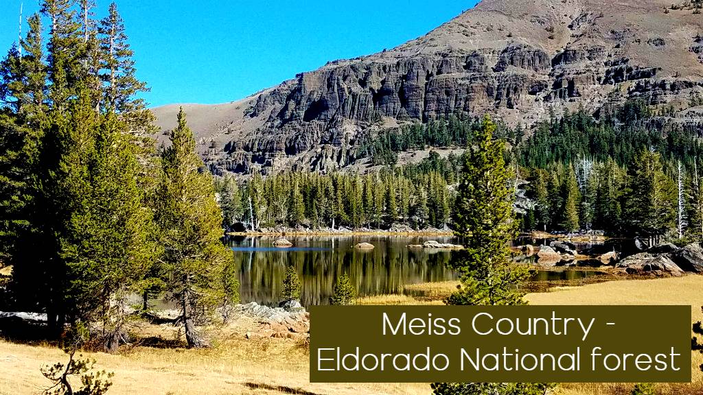
Pronounced “Mice,” Meiss Country has quietly become one of the most popular outdoor destinations in the South Lake Tahoe region for hiking, biking, and backpacking.
Located between Luther Pass (Hwy 89), Carson Pass (Hwy 88), and Echo Summit (Hwy 50), this region offers a mix of alpine lakes, open meadows, forested trails, and scenic peaks. Managed in partnership by Eldorado National Forest and the Lake Tahoe Basin Management Unit, Meiss Country delivers a true Sierra experience without the pressure of heavy permitting systems.
For many visitors, it has become a reliable alternative to Desolation Wilderness—especially for those looking to explore similar terrain without the same permit challenges. It also is an easy connection with Carson Pass Hiking and Backpacking destinations

Why Hike Meiss Country?
Meiss Country stands out for its accessibility and variety.
- Well-established trail system
- Access to both the Pacific Crest Trail and Tahoe Rim Trail
- Scenic lakes, meadows, and open terrain
- Multi-use access for hiking, biking, and backpacking
It’s one of the best places near Lake Tahoe to explore beyond the typical high-traffic destinations.
Popular Hiking Routes in Meiss Country Lake Tahoe

Big Meadows to Round Lake and or Dardanelle Lake:
Round Lake
Distance: 2.7 miles one way
Difficulty: Moderate
Round Lake is one of the most accessible alpine lakes in Meiss Country.
Starting from Big Meadows off Highway 89, the trail climbs through Jeffrey pine and white fir before opening into a wide meadow. From there, it continues through lodgepole forest before descending toward the lake, framed by volcanic rock formations. A Secondary route from Either Carson Pass or Echo Summit is accessible via the PCT and Cutting Down to Round Lake. Makes a great Mini through Hike for backpackers.
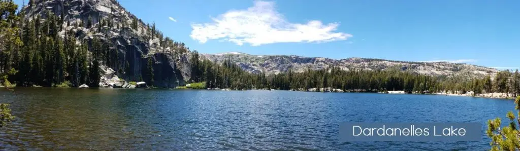
Dardanelles Lake
Distance: 7.5 miles round trip from Luther Pass or 10 mile round Trip from Christmas Valley
Difficulty: Moderate
From the Round Lake trail junction, take the alternate fork and follow a less-defined path through willows and stream crossings. Dardanelles is a more dramatic and popular lake for day hikers and backpackers from lake Tahoe.
The lake sits beneath granite cliffs and open rock shelves, creating a dramatic and scenic setting that feels more remote than the mileage suggests.
Big Meadows to Scott Lake
Big Meadows to Scott Lake
Distance: ~2.5 miles one way
Difficulty: Easy
A gradual climb through forest leads to open terrain and a quieter lake setting. Follow directions to Round and Dardanelles Lake until you reach the Scotts Lake trail junction at Big Meadow. Here the trail climbs upward at a gradual pace through Jeffrey pine, and fir, high above Big Meadow. A great hike in the fall, the trail travels through a beautiful aspen grove which opens into a valley covered with juniper and sagebrush. A short distance further, the trail turns into a
jeep road, leading to Scotts Lake.
Big Meadows to Scott Lake Easy
Christmas Valley to Dardanelles Lake and or Round Lake

An alternate route to Dardanelle and Round Lakes is found a bit lower on the mountain and off the beaten path in Christmas valley. this trail is one of sierra Rec teams favorites and is a great summer or fall hike. this hike is moderate and is a popular trail for mtn bikers so caution on the trail is required, but as the hike climbs through both forest and old burn area before crossing a creek and and aspen lined trail segment to Lake Dardanelle visitors are also welcomed with great vista views of South lake tahoe from the trail as well.

Carson Pass to Showers Lake
Distance: 5.1 miles one way
Difficulty: Moderate
Starting at Carson Pass, this route follows the PCT North through behind Red Lake Peak and Stevens Peak then through the beautiful Meiss meadow and lake basin before climbing again to Showers Lake
Take Hwy 89 to Hwy 88, turn right at junction. Drive 8 miles to Carson Pass. (There is a fee to park.)
Carson Pass to Echo Summit Backpacking Route
Distance: 13.2 miles
Type: Point-to-point
A classic section hike along the PCT.
This route includes Showers Lake and Meiss Lake, making it a strong option for an overnight backpacking trip or a longer day hike for experienced hikers.
A Local favorite for PCT section hikes and is a great backpacking trip with Showers or Meiss Lakes as feature locations for a camping over night.

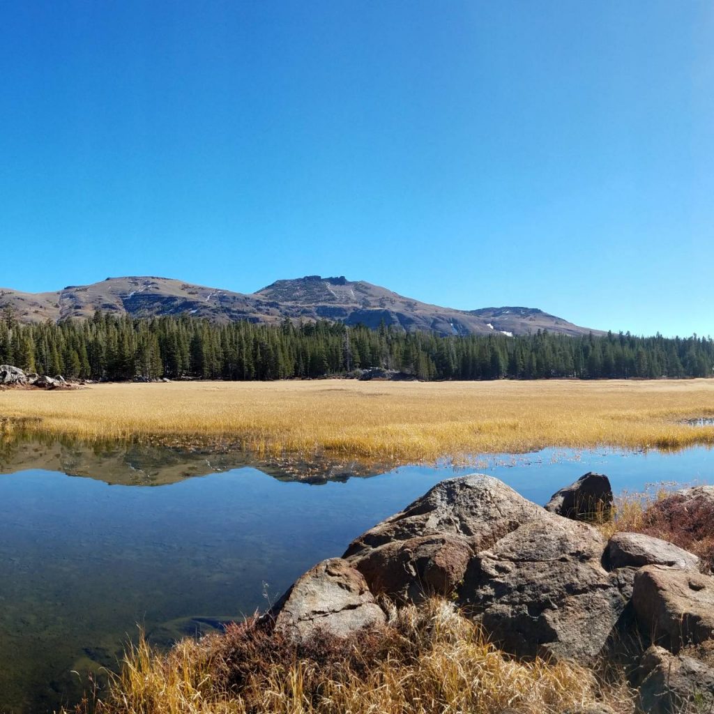
Carson Pass to Meiss Lake
Distance: ~4 miles one way
Difficulty: Moderate
This route climbs gradually from Carson Pass before crossing the Upper Truckee River and entering a wide meadow.
Meiss Lake is shallow but scenic—and notably one of the warmer lakes in the region, making it a popular spot for a quick swim.
Note: Fishing is not allowed at Meiss Lake.
Carson Pass to Luther Pass (Big Meadow)
Distance: ~8 miles
Difficulty: Moderate
This through-hike connects major trail systems including the PCT and Tahoe Rim Trail.
It passes through Meiss Meadows and offers access to Round Lake and Christmas Valley, making it one of the more versatile routes in the region.
Campfire Restrictions
For the safety of the forest and surrounding communities, strict fire regulations are in place.
- Campfires and charcoal are not allowed in Meiss Country
- Fires are only permitted in designated campgrounds with metal fire rings
- Portable gas stoves are allowed with a valid California Campfire Permit
👉 Obtain permit: http://www.preventwildfireca.org/Campfire-Permit/
Sierra Rec Insight
Meiss Country fills a unique gap in the Tahoe region.
It offers the same alpine feel—lakes, meadows, and long trail systems—but without the same level of crowding or permit pressure found in nearby Desolation wilderness areas.
For hikers willing to explore just beyond the obvious destinations, this area opens up into one of the most rewarding trail systems in the Sierra.

Hi –
My partner and I are planning to backpack in Meiss this weekend. Any idea what the condition are like (snow, ice)? Also, do you know of a good hardcopy map we can take with us that will include this area? Thanks!
Miri,
I have not made it up their yet this year but base don snow pack and warm weather this year you will most likely find dirt trails with occasional snow pack covering the trail. I highly recommend the Tom Harrison maps https://tomharrisonmaps.com/product-category/northern-ca-maps/ you can find them at most outdoor stores in the area i believe. The other map I have of tis area is the National Geographic maps which i believe is the map Tahoe rim trail uses. Have a great trip. thanks for visiting.
Thanks for the info! If we head out there this weekend, I will be sure to let you know how the trail is.