By Charlie Pankey | Sierra Rec Magazine
There’s something ancient about the sound of a fast-moving creek echoing through a canyon. It’s a sound that draws you in—pulls you toward mystery, motion, and a little bit of magic. On a warm spring morning just west of Chester, California, I found myself exploring that sound along the Deer Creek Trail off Highway 32. I expected a simple hike. What I got was a geology-rich adventure through volcanic pillars, wildflower-laced switchbacks, and a front-row seat to nature’s resilience.

Trail Overview
- Trail Name: Deer Creek Trail to Fish Ladders and Lower Deer Creek Falls
- Length: 4.6 miles round-trip (out-and-back)
- Difficulty: Easy to moderate
- Trailhead Access: Red Bridge crossing on Highway 32
- Season: Best in spring (April–June) for wildflowers and high flows
- Use: Day use only
- Managed By: Deer Creek Preserve & The Land Conservancy (landconservation.org)
Note: This trail crosses private land and enters a designated wildlife preserve. Please respect posted signs. No camping or fires allowed from 1.3 miles past the trailhead to Forest Road 27N08 (K-Line).
A Walk into the Wild: Starting at Red Bridge
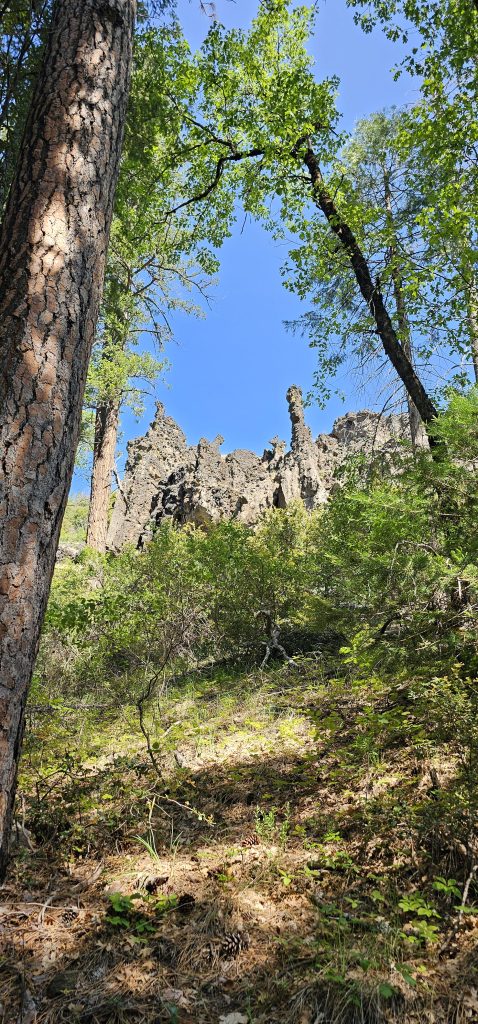
The trail begins quietly from the Red Bridge pullout on Highway 32—no big sign, just a small parking area and a trail that gently slips into the forest next to bridge into the Lassen National Forest. Almost immediately, you’re greeted by fascinating geology. The first mile of trail winds beneath towering pines and old oaks, with volcanic pillars rising dramatically from the hillside above. These dark, jagged formations look like the remains of a prehistoric spine, jutting out of the earth with a quiet authority that instantly captivates.
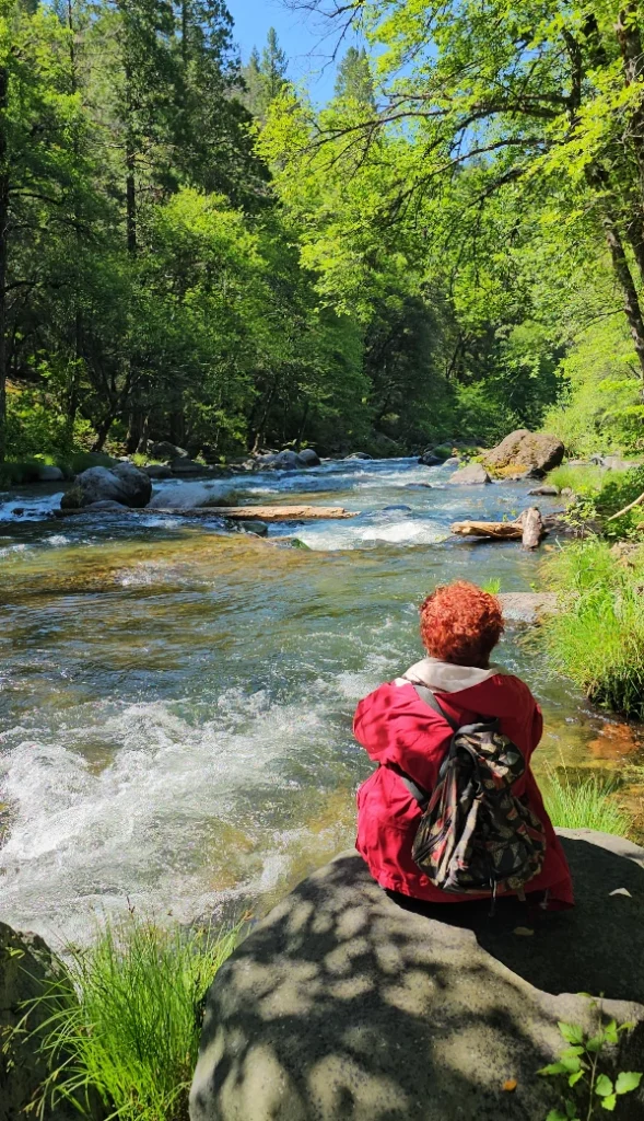
In this early section, the trail stays mostly close to the river, and there are several spots where the forest opens up just enough to reveal inviting day-use areas. We even came across one well-developed unofficial camping spot, tucked near a flat bend in the creek—though camping is prohibited beyond the 1.3-mile mark into the Deer Creek Preserve. The river here is broad and lively, its banks perfect for fishing, photography, or simply sitting and listening.
Shade is plentiful throughout the hike, with cedar, manzanita, and dense oak overhead. This part of the trail feels both accessible and wild—an easy rhythm to follow, where you can pause often and never feel rushed.
About 400 yards before reaching the gorge and fish ladder, the trail becomes overgrown with tall grass. It’s a striking shift, and while beautiful, we found ourselves on alert for snakes. This patch also happened to be where the spring wildflowers truly showed off—lavender and yellow bursts lining the trail in waves.
Into the Preserve: Where the Trail Narrows and the River Roars
Roughly a mile in, you cross into the Deer Creek Preserve, a public-private partnership designed to permanently protect the river’s habitat. From here, the trail becomes more enclosed. The cliffs grow steeper, and thick foliage limits your access to the water until you reach the gorge.
That sound? It gets louder. You’ll hear it before you see it.
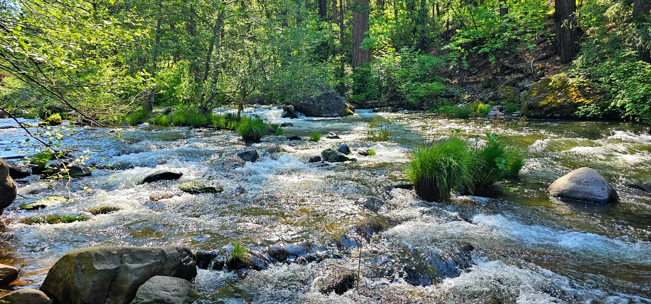
The trail emerges at a dramatic rock chute and fish ladder system, where the creek crashes through a narrow canyon with intense force. Here, Lower Deer Creek Falls drops nearly 20 feet into a swirling pool surrounded by dark granite and moss-covered boulders. The fish ladder—a series of carved rock steps and bypass channels—lets salmon bypass this turbulent plunge during spawning season.

There’s a reverence to this space. It’s powerful, loud, alive. You can feel the canyon breathing.
We lingered. Took it all in. Snapped photos. Watched the mist rise. The water was far more powerful than we expected—a reminder of what spring means in the Sierra foothills.
Beyond the Falls: The Trail Continues
We weren’t sure what lay beyond the fish ladder. The trail continues, though information was limited. It likely connects to additional forest roads or higher creek access. But for us, the gorge and falls felt like the natural turnaround point.
One note: the trail surface is covered in acorns in some sections—a detail I’d never really encountered before, but one that gave the path a uniquely wild texture.
Bonus Stop: Deer Creek Falls
If you’re not done chasing water just yet, continue a few miles north on Highway 32 and look for a small pullout near Deer Creek Falls. A short 250-yard descent brings you to a stunning plunge over a volcanic cliff into a deep pool below. Sunlight cuts through the forest canopy here, and the mist rising from the water catches the light in all the right ways.
This spot is less of a hike and more of a photo-worthy viewpoint—but it’s absolutely worth the detour.


Final Thoughts
Deer Creek surprised me—not just with its waterfalls and geology, but with its spirit. The fish ladders show what happens when humans and ecosystems work together. The preserve offers a blueprint for conservation and access. And the hike? It’s a perfect reminder that the best trails often start with few expectations.
If you’re planning a spring waterfall adventure in the Lassen foothills, make sure Deer Creek is on your list.
#DeerCreekFalls
#WaterfallsOfCalifornia
#TrailTestedStories
#SierraRecMagazine
#VisitPlumasCounty
