Plan by region, plan backwards, and build a summer you don’t waste
January and February are when my Sierra year actually begins.
Not because summer is close—it isn’t. Not because the snow is gone—it’s not. But because this is the quiet season when the maps come out, the imagination wakes up, and the right kind of planning removes pressure later.
I love winter in the mountains. I love snowshoeing where the trail disappears and the forest goes quiet. I love the days when the Sierra feels like it belongs to the weather, not the crowds. But at the same time, I’m also already thinking ahead—because I’ve learned something after years of chasing summer: the best Sierra seasons don’t start at the trailhead. They start at home, long before the first drive.
This is the season of possibility. The season of opening drawers of old paper maps and spreading them out across the floor. The season of pulling guidebooks off shelves and reading the same paragraph twice, not because I forgot it—but because I’m trying to picture it. The season of toggling between topo lines and satellite imagery, zooming into granite basins, river bends, high passes, and small lakes that look like they’re hiding just out of sight.
If there’s a pattern to what pulls me in, it’s water.
Rivers. Lakes. Valleys. A blue line running through a remote section of map is often enough to get me dreaming. Sometimes it means crossing a pass. Sometimes it means committing to bigger miles. But more often, it means the kind of trip that stays with you—one basin at a time, one day at a time, moving through country that feels endless if you let it.
In the early years, I tried to see too much. I treated every summer like a race against time. I wanted new routes every trip, new trailheads every year, and I didn’t want to repeat myself. I still love new terrain—but I don’t plan that way anymore. The Sierra doesn’t reward hurry. It rewards patience, timing, and return.
Now my planning looks different. It looks like building a short list, not a long one. It looks like choosing a region—then choosing the season when that region is at its best. It looks like matching dreams to reality: snowpack, permits, fire season, trail access, and my own calendar. And it looks like building options, because no matter how well you plan, the Sierra will still have a vote.
That’s the point.
This feature is the planning system I use to shape a year that doesn’t get wasted. We’ll go region by region—Northern Sierra, Tahoe and Desolation, the central spine of Yosemite and Emigrant, the wide-open Eastern Sierra, and the bigger commitment of the Southern range. Then we’ll plan backwards from summer, using winter as the starting line.
If you do this work now, you don’t spend July staring at a map asking where to go. You spend July already driving—early, prepared, and ahead of the pressure.
“By the time summer arrives, I don’t want to be asking where to go. I want to be leaving.”
Upper Long Lake – Hoover Wilderness
THE SIERRA YEAR AT A GLANCE
Choose a region first. Everything gets easier after that.
The Sierra is too big to “do it all” in one year. The simplest way to plan a season that feels intentional—and actually happens—is to choose a primary region (or two), then plan backwards from the best window for that place.
Use this spread as your starting point. Pick the region that matches what you’re craving, then keep reading for the deeper planning notes.
Mill Creek trail along the shores of Bucks Lake
NORTHERN SIERRA
Best window: June–October (shoulder seasons shine) Trip style: Lakes, ridgelines, quieter basins, weekend loops Permit pressure: Low–Medium Crowd factor: Low–Medium What you’re chasing: Hidden lakes, forest solitude, big-country views without the big pressure
Why start here: You can build a full summer of trips without fighting for every trailhead.
Long Lake on the Bishop Pass Trail
EASTERN SIERRA
Best window: June–October (wide seasonal range) Trip style: High passes, big elevation, basin-to-basin travel, dramatic terrain Permit pressure: Medium (varies by trailhead/agency) Crowd factor: Medium at popular entry points What you’re chasing: High country that feels immediate—ridges, lakes, and big skies
Why start here: It’s a planner’s region. You can cluster trips and build momentum.
At the Western Edge of Ropi Lake
TAHOE + DESOLATION
Best window: July–September (early starts matter) Trip style: Iconic granite, short overnights, day hikes with big payoff Permit pressure: Medium–High (varies by entry and use) Crowd factor: High near easy access What you’re chasing: Granite bowls, alpine lakes, high ridges close to town
Why start here: Fast access makes this region easy to visit—and easy to underestimate.
SOUTHERN SIERRA
Best window: July–September (heat + access matter) Trip style: Longer trips, bigger drives, higher commitment, high reward Permit pressure: Medium–High (varies) Crowd factor: Medium (but concentrated in famous areas) What you’re chasing: The deep Sierra—long miles, serious basins, a sense of scale you can’t fake
Why start here: This region rewards people who commit early and build real margin.
Yellowhammer Lake Emigrant Wilderness
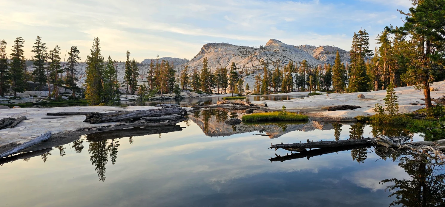
CENTRAL SIERRA: YOSEMITE + EMIGRANT
Best window: July–September (timing is everything) Trip style: Big basins, classic routes, ambitious loops, off-trail options Permit pressure: High in Yosemite / Low–Medium in Emigrant Crowd factor: High at famous corridors, lower deeper in What you’re chasing: Granite wilderness, high lakes, long views, routes that feel like a story
Why start here: If you plan well, you get the kind of trip people talk about for years.
“Pick the region first. The rest of the year starts to organize itself.”
Northern Sierra: The Quiet Advantage
If you want a Sierra year that feels calm, the Northern Sierra is where I’d start.
This part of the range doesn’t always get the spotlight the way Yosemite or the Eastern Sierra does, but that’s exactly why it works. You can build a full season of hikes and overnights without constantly fighting crowds, reservations, and permit anxiety. It’s the kind of country that rewards people who like finding their own rhythm—lakes tucked beyond forest ridges, basins that don’t make everyone’s “top 10” list, and trails where you can still hear the wind.
In winter planning mode, I treat the Northern Sierra like a foundation. I don’t need every trip to be the biggest trip. I need a reliable region that keeps me outdoors often, keeps the driving manageable, and gives me room to explore without pressure.
Best Window
Most years, the Northern Sierra shines from June through October, with strong shoulder-season potential depending on snowpack and weather. Early summer can still hold snow in higher pockets, but you’ll often find workable elevation bands sooner than you expect—especially for day hikes and shorter loops.
How I Plan It
I plan this region in layers:
Start with water. Find a cluster of lakes or a drainage that draws you in, then look for multiple ways to approach it.
Think in loops and “add-ons.” A trip becomes better when it has options: a side lake, a ridge, a small basin beyond the obvious stopping point.
Build a weekend ladder. Identify a few day hikes that can turn into overnights later. This gives you flexibility as the season evolves.
The Northern Sierra also makes it easier to plan around real life. If you only have Saturday, you can still get a meaningful day. If you have a two-night window, you can still build a trip that feels like you stepped into the backcountry.
What to Watch For
This region’s biggest wild card isn’t crowds—it’s seasonal change. Snowpack can delay access. Summer heat can push you toward higher elevation. Late-season storms can arrive earlier than expected. And in modern Sierra planning, you can’t ignore the impact of fire season on road access and trail conditions.
The good news is that when you plan the Northern Sierra well, you’re rarely locked into one single trailhead. You can pivot without losing the trip.
Tahoe and Desolation: Iconic Country, Real Planning
Tahoe and Desolation can give you some of the most rewarding days in the Sierra—and some of the most frustrating ones if you don’t plan.
This region is close to roads, close to towns, and close to millions of people who want the same thing you do: alpine lakes, clean granite, and a fast escape. Because access is easy, pressure concentrates quickly. That doesn’t make Desolation less special. It just means the “before the trailhead” part matters more here than almost anywhere.
I’ve spent a lot of time in Desolation. It’s one of those places that delivers what you came for—if you show up prepared and choose your timing wisely.
Best Window
Desolation and the Tahoe backcountry typically peak July through September for snow-free travel, with shoulder-season opportunities on either side depending on conditions. If you want the region to feel calmer, your two best tools are:
early starts
midweek windows
A Tuesday morning entry can feel like a different wilderness than a Saturday morning entry.
How I Plan It
For Tahoe/Desolation, I plan around three realities:
Access pressure is predictable. It’s not a mystery why it’s busy. That means you can plan smarter.
A small mileage day can still feel huge. You don’t need long distances to get high value here—especially if you go beyond the first obvious lake.
Options matter more than ambition. Having a second route option often makes the day.
I start by picking a primary destination, then immediately choose a secondary one that serves as a pivot—another basin, another ridge, another exit route. That way, I’m not forcing one plan into a crowded trailhead or a weather shift.
What to Watch For
This is where planning gets practical:
Parking and trailhead logistics can make or break the day.
Permits and usage rules vary by entry point and season—know them early.
Crowds are real, especially near the most famous lakes and short-access routes.
But here’s the truth: if you plan well, Tahoe and Desolation are some of the best “high reward per mile” terrain in the range. Granite bowls, open ridges, and lakes that catch the light in a way that makes you forget you’re close to town.
“In Desolation, the difference between magic and frustration is often a 6 a.m. departure.”
Central Sierra: Yosemite and Emigrant
If you want a Sierra trip that feels like a true journey—granite basins, long views, high passes, and that sense of moving deeper into the range—the Central Sierra is where it happens.
This is also where planning matters most.
Yosemite’s high country has a way of becoming people’s “one big trip.” The danger isn’t the ambition. The danger is attaching everything to a single plan: one trailhead, one start date, one route you refuse to let go of. That’s how people end up spending peak summer weeks frustrated, stuck in logistics, or defaulting to the most crowded version of the experience.
My winter planning approach here is simple: build the dream, then build the options.
Best Window
In most years, the Central Sierra peaks from July through September for backpacking and high-country travel. Early season can be held back by snowpack, and late season can shift quickly with cold nights and early storms. The best trips here often happen when you plan a window—and stay flexible within it.
How I Plan It
The Central Sierra is where I lean hardest on maps and satellite imagery. This terrain looks dramatic on a screen, but the real work is understanding what it feels like on foot: where the climbs are, how long the traverses take, where water will be reliable, and where you have real exit options if you need them.
I also plan this region as a “story route,” not a checklist. I’m drawn to basins and water first, then I connect them with ridgelines, passes, and travel corridors that create flow. Sometimes that’s an established loop. Sometimes it’s a route with small off-trail variations that make the experience feel personal.
This is also where I pay attention to the reality of my calendar. Longer drives, longer routes, and permit windows mean I plan Central Sierra trips around vacation time and midweek starts whenever I can. A Thursday entry changes everything—crowds, logistics, and often the kind of permit you can actually obtain.
Yosemite and Emigrant: The Two-Track Strategy
Here’s the practical truth: Yosemite is iconic and can be hard to access cleanly in peak season. Emigrant can be a pressure-release valve that still gives you high-country basins, lakes, and space.
When I plan this region, I treat it like two tracks running side-by-side:
That way, I’m never locked into one outcome. I still get a true Central Sierra experience, even if the exact version changes.
“Build the dream—then build the options. The Sierra always gets a vote.”
Eastern Sierra: Big Sky, High Passes, and a Planner’s Playground
The Eastern Sierra is where planning feels both easier and more demanding at the same time.
Easier because the landscape is open, the basins are dramatic, and the route ideas almost build themselves once you start studying maps. More demanding because the terrain is high, the weather can be sharp, and altitude adds a layer of reality you can’t ignore.
This is the region that makes me think in clusters: one drive, multiple adventures. If you’re traveling from farther away—or planning fewer but more targeted trips—this is where you can get the most value out of a season when you plan it well.
Best Window
Eastern Sierra travel can stretch from June through October, depending on snowpack, access to high passes, and how comfortable you are with shoulder-season cold and wind. There are years when early summer still holds snow high up, and years when late September feels like mid-summer in the day and winter at night.
You plan the Eastern Sierra by respecting that range.
How I Plan It
My winter routine for the Eastern Sierra looks like this:
Choose a basin first. I let one drainage or lake cluster become the anchor.
Study the passes. Passes aren’t just scenery here—they’re your connectors.
Build a route ladder. I plan a day hike version, an overnight version, and a 3–4 night version of the same area. This gives me options based on time, weather, and fitness.
Altitude matters, too. I plan acclimation into my trips when needed. I plan for wind. I plan for the reality that weather can feel harsher on the east side even when the forecast looks mild.
And I plan for light. The Eastern Sierra rewards early mornings and long evenings. When the day is clear and you’re moving through high country with room around you, it can feel like the Sierra at its most honest.
“In the Eastern Sierra, one good basin can power an entire season.”
Southern Sierra: The Big Commitment
The Southern Sierra is the part of the range I treat with the most respect—not because it’s “harder” in some bragging-rights way, but because it asks for more commitment. Longer drives. Bigger elevation. More exposure to heat early in the season. And often, longer trip designs that don’t leave you a lot of easy shortcuts once you’re deep.
When people talk about the “real Sierra,” this is often what they mean: deeper country, bigger basins, longer traverses, and a sense of scale that makes you slow down whether you want to or not.
This is also the region where winter planning pays off the most.
Best Window
Most Southern Sierra backpacking peaks in July through September, when access is open and high routes become reliably workable. Early season can be constrained by snow at elevation, while mid-summer can carry heat concerns in lower approaches. Late season can be ideal for fewer crowds, but weather shifts fast once nights start to drop.
In other words: timing matters here—sometimes more than in any other region.
How I Plan It
My winter planning approach for the Southern Sierra has one goal: remove the pressure to make one trip carry the whole season.
The Southern Sierra is the region that tempts people into building a “once-in-a-lifetime” plan. And that’s where mistakes creep in: pushing mileage too hard, choosing routes without margin, or feeling stuck because you’ve attached everything to a single trailhead and a single week.
Instead, I plan it like this:
Choose one anchor trip you truly want—something worth committing to.
Choose one “shorter” alternative in the same broader region that still feels meaningful if conditions shift.
Build exit awareness into your route design. Not because you plan to bail, but because smart planning keeps decisions calm if you need them.
And I plan the Southern Sierra around recovery. Bigger miles require better sleep, better food planning, and honest pacing. This isn’t the region where you win by rushing. You win by staying steady and letting the country unfold.
What to Watch For
Heat and exposure on lower-elevation approaches
Snowpack timing in high basins and on passes
Long drives that turn a “three-day trip” into a bigger logistical effort
Fire season and closures, which can shift access late in summer
The Southern Sierra will always be there, and it deserves patience. Plan early, commit wisely, and leave room for the Sierra to change the story without ruining it.
“The Southern Sierra isn’t a casual decision—so make it early, and make it count.”
Plan Backwards: Your Summer Starts in Winter
When I say I “plan backwards,” I mean I start with the trip I want most—then work in reverse until I’m standing in January with a plan I can actually execute.
This doesn’t require a perfect schedule. It requires a simple structure:
choose a region
choose the best seasonal window
match it to your real calendar
then build options so you’re never stuck
Think of Page 10–11 as your Sierra planning timeline. The goal isn’t to lock every weekend. The goal is to avoid arriving in peak summer with no plan, no permits, and no margin.
JANUARY–FEBRUARY: DREAM + MAP + SHORTLIST
This is the quiet work that makes summer easier.
What to do now
Pick one primary region for your biggest trip
Pick one secondary region for backup weekends
Pull out your maps, open satellite imagery, and start building a shortlist
Identify the lakes, basins, or rivers that are pulling you in—and the trails that reach them
Start a simple notes file: “2026 Sierra Ideas” (regions + routes + timing)
The key mindset
You’re not trying to plan everything
You’re trying to choose what matters most and build options around it
Pull Quote Option: “Winter planning isn’t about control—it’s about freedom when the season arrives.”
MARCH–APRIL: CHOOSE THE SPINE OF YOUR SEASON
Now you turn the shortlist into a plan with structure.
What to lock in
Your top 1–2 backpacking trips (or long weekends)
Your backup options if permits, snowpack, or access shift
The trips that require the most logistics: longer drives, bigger mileage, or higher demand
What to review
permit requirements by region and agency
realistic mile ranges based on your fitness and time
your vacation calendar—midweek starts if possible
MAY–JUNE: ADJUST TO REAL CONDITIONS
This is where many people either panic or get stuck. Planning backwards prevents that.
What to do
Use snowpack and access reality to confirm your early-season plans
Shift elevation bands if needed
Confirm trailhead access and road openings
Book what needs booking (travel, shuttle logistics, lodging if part of the plan)
What you’re protecting
your ability to leave quickly when a window opens
your ability to pivot without losing the trip
JULY–AUGUST: EXECUTE PEAK TRIPS, KEEP ONE FLEX WEEKEND
By July, the Sierra becomes louder. More people. More pressure. More traffic at the same trailheads everyone bookmarked in winter.
This is where planning backwards pays off. If you’ve done the work early, summer doesn’t feel like a scramble. It feels like a sequence.
What to do
Run your primary backpacking trip(s) in the best window you identified
Keep one flex weekend uncommitted—this becomes your weather/crowd escape hatch
Use your shorter weekends to explore nearby basins and “add-on” routes you flagged during winter planning
What to watch for
heat at lower approaches
smoke and fire impacts that shift regional access
crowd pressure at famous corridors
The mindset Your best summer isn’t the one where you force every plan. It’s the one where you execute the trips that matter—and pivot calmly when the Sierra changes the terms.
SEPTEMBER: THE HIKER’S MONTH
If I had to pick the month that most consistently delivers the Sierra I want, it’s September.
The days are still long enough. The nights are cooler. Water is still there if you planned for it. Bugs settle down. And a lot of the summer rush begins to fade.
What to prioritize
your “heart trip” if you haven’t used it yet
longer backpacking loops
high basin travel that benefits from cooler temps and steadier footing
Why it works September rewards people who planned early enough to keep the calendar open—and who didn’t burn themselves out in July.
Pull Quote Option: “September is where the Sierra feels like itself again.”
OCTOBER: SHOULDER-SEASON MAGIC (WITH A SHORTER LEASH)
October can be spectacular—clean air, sharp light, quiet trailheads. It can also change fast.
How to plan it
keep trips shorter and closer to the car
choose routes with clean exit options
be honest about daylight and cold
What it’s best for
day hikes with big payoff
one-night overnights when weather is stable
revisiting familiar trails with a new seasonal lens
Permits Without Panic: How to Keep the Dream Without Getting Stuck
Permits are part of modern Sierra travel. That’s not a complaint—it’s just reality.
But what I’ve seen again and again is that permits don’t break people’s summers. Attachment breaks people’s summers.
When your identity gets pinned to one trailhead, one date, and one exact route, you create a situation where a single “no” can ruin the season. Planning backwards is meant to remove that pressure. Your job isn’t to force one plan into existence. Your job is to build a plan that can bend and still deliver the experience you’re chasing.
Here’s the permit mindset that works year after year:
1) Protect the Experience, Not the Entry Point
If you know what you want—high lakes, granite basins, a quiet loop, a river corridor—you can often reach that feeling through multiple trailheads and multiple route designs.
The permit is the doorway. The experience is the house.
2) Plan in Options, Not Absolutes
This is the simplest system I know:
If your trailhead is fixed, keep dates flexible
If your dates are fixed, keep trailheads flexible
If both are flexible, your odds and your peace of mind go way up
3) Build a “Backup That Still Matters”
Your backup plan should not feel like a consolation prize.
A good backup is:
in a different region window
or in a similar terrain style with lower pressure
or a shorter trip that still gives you a real wilderness experience
This is how you keep momentum. It’s how you avoid the common trap of spending all summer waiting for the “perfect” plan to open up.
Closing: What Winter Planning Really Gives You
In winter, it’s easy to dream big. It’s also easy to freeze up under the weight of all the options.
The Sierra is too vast to finish. That’s the gift. Choose a region. Choose a seasonal window. Plan backwards. Build your options. Then leave room for surprise—because the moments you remember most rarely happen exactly as planned.
By the time summer arrives, I don’t want to be asking where to go. I want to be leaving—with a plan strong enough to guide me, and flexible enough to let the Sierra do what it does best.
“The best Sierra seasons begin before the trailhead.”