

Additional areas of Death Valley National Park opening 12/23: North Highway, Ubehebe Crater, and The Racetrack
DEATH VALLEY, Calif., December 23, 2023 – On Saturday, Death Valley National Park will reopen 95 miles of flood-damaged roads. Pockets of wildflowers and cool temperatures make this an ideal time to visit the park.
It’s an ideal time to visit Death Valley National Park, according to Superintendent Mike Reynolds. “The hiking in December and January is superb. Added to that, there’s a temporary lake at Badwater and some wildflowers are out.”

The roads will open four months after they were heavily damaged by flash floods caused by the remnants of Hurricane Hilary. The repairs were funded by a combination of the National Park Service’s (NPS) Disaster Supplemental and Federal Highway Administration’s (FHWA) Emergency Relief for Federally Owned Roads (EFRO) programs. The repairs were done by contractors, NPS employees stationed in Death Valley National Park, and NPS employees assisting from other parks across the country.
Roads reopening on Saturday, Dec. 23 include:
- North Highway
- Ubehebe Crater Road
- Old Stovepipe Well Road
- Lower end of Titus Canyon Road
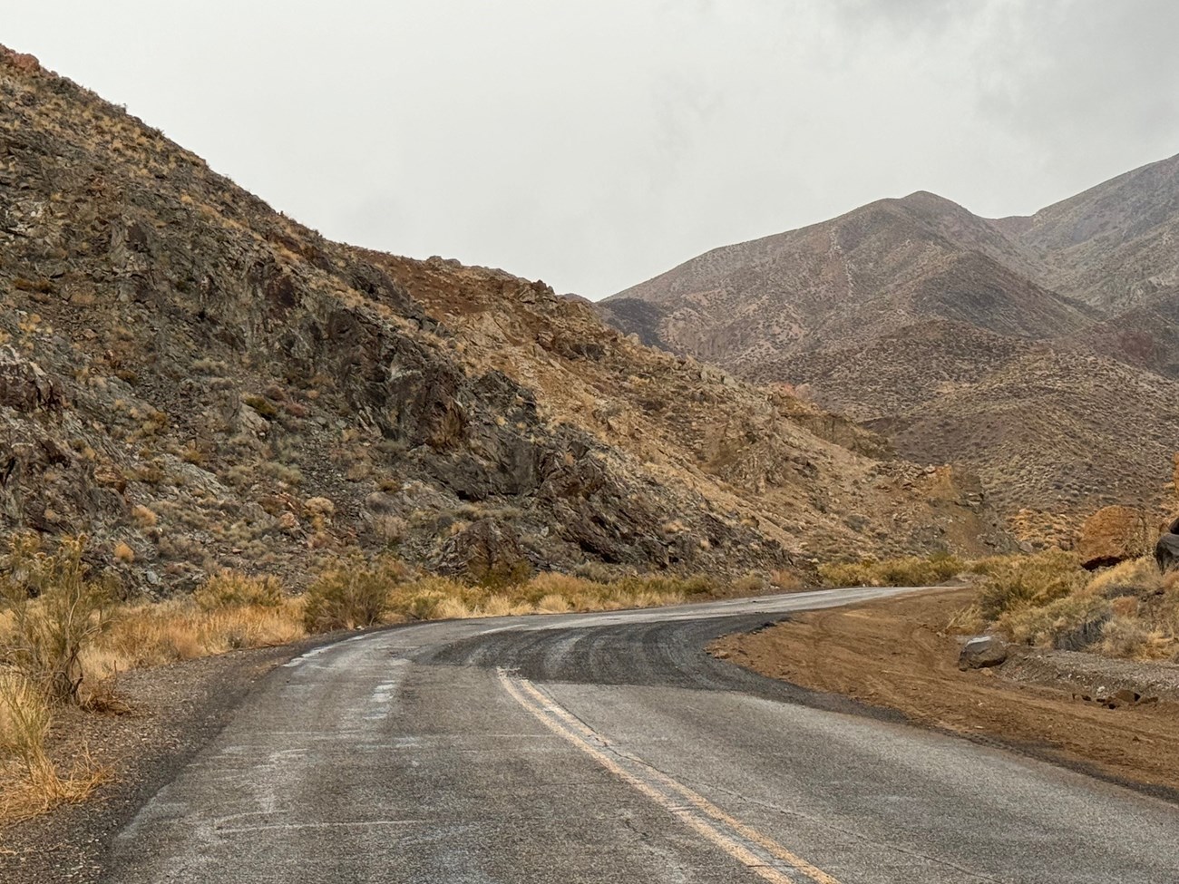
- Racetrack Road
- Lippincott Road
- Hidden Valley Road
- Lost Burro Mine Road
- White Top Mountain Road
These roads provide access to some of the park’s iconic features. Ubehebe Crater is a 600-foot-deep volcanic crater. There are currently unseasonable patches of pink and yellow flowers on crater’s black slopes.
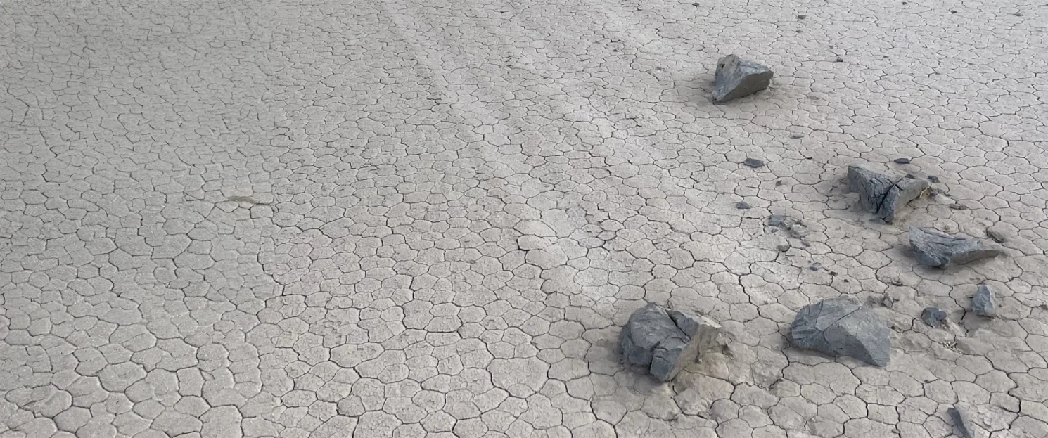
The Racetrack is famous for tracks left by moving rocks on the dry lakebed. A lake was present for at least a month after Hurricane Hilary. Now the lakebed is dry again, so people can walk on it without causing damage. No vehicles or bicycles are allowed on the Racetrack.
Many of the park’s roads, including Racetrack Road, are only suitable for high clearance vehicles. Many park roads remain closed until flood repairs are completed. Mesquite Springs Campground will likely open before December 31. Information on Death Valley’s camping, lodging, activities, and road conditions is at nps.gov/deva.
Southern backcountry roads open: Harry Wade Road & Warm Springs Road

On December 12, the National Park Service (NPS) announced that 60 additional miles of backcountry roads in the southern end of Death Valley National Park are now open.
Warm Springs Road is fully open. People with high clearance 4×4 vehicles can drive over Mengel Pass between Death Valley and Panamint Valley. Warm Spring Canyon Gold and Talc Mining Historic District, Butte Valley, and Barker Ranch are points of interest along the way.
West Side Road remains closed north of the junction with Warm Springs Road.
Harry Wade Road is a 4×4 route that connects Badwater Road to CA-127 on the park’s southeastern corner. The NPS has only completed interim repairs on the road. Extended sections of the road are a single lane between deep sandy berms, with limited opportunities to pass oncoming vehicles.
All 1,400 miles of roads within Death Valley National Park were damaged by the remnants of Hurricane Hilary on August 20. The NPS, Federal Highway Administration, Caltrans, and Inyo County continue their work to repair the park’s roads.
Additional Openings in the Past few weeks in Death Valley
Portions of Eureka Valley and Saline Valley opened on November 30.

Eureka Valley and Saline Valley can only be accessed by entering the park from Big Pine, CA. These roads were repaired by Inyo County.
Eureka Dunes are the tallest dunes in California. The Big Pine – Death Valley Road is open from Big Pine to Eureka Valley. It is closed east of the Eureka Valley junction. Eureka Dunes primitive campground is now open. Eureka Valley Road / Steel Pass Road is closed past the campground due to flood damage.
The soaking tubs and primitive campground at Saline Valley Warm Springs are now open. The only route open to drive there is from Big Pine, CA over Saline Valley Road’s North Pass. Saline Valley Road’s South Pass and Steel Pass Road past Palm Springs are still closed due to flood damage.
Roadside Camping and Backpacking openings
Roadside camping and backpacking is now available along Echo Canyon Road, Hole in the Wall Road, Cottonwood Canyon Road, Marble Canyon Road, and Greenwater Valley Road (aka Furnace Creek Wash Road). The free, mandatory camping permits are available at Furnace Creek Visitor Center, same day only.
Inyo County graded Greenwater Valley Road. The adjoining Deadman Pass and Gold Valley Roads are open, but have not been maintained. Conditions in Gold Valley Road may be challenging even for vehicles with 4×4 high clearance.
-www.nps.gov/deva-
Death Valley National Park is the homeland of the Timbisha Shoshone and preserves natural resources, cultural resources, exceptional wilderness, scenery, and learning experiences within the nation’s largest conserved desert landscape and some of the most extreme climate and topographic conditions on the planet. Learn more at www.nps.gov/deva.

