
By Charlie Pankey, Sierra Rec Magazine
Escape the crowds and experience one of the Eastern Sierra’s most rewarding early-season alpine hikes.
Hiding just off Highway 108, Leavitt Lake is a rugged, high-elevation gem near the summit of Sonora Pass that offers solitude, snowmelt waterfalls, and glacier-fed beauty just as the Sierra awakens in late spring. While the lake is often reached by high-clearance 4×4 in summer, an early-season hike up the closed Leavitt Lake Jeep Road offers a wild, trail-tested adventure with dramatic alpine rewards.

A Bluebird June Day in the High Sierra
This past weekend, I needed trail time—badly. The itch to get some early-season miles in was relentless, and Sonora Pass kept calling. So I loaded up in Carson Valley, grabbed some last-minute supplies, picked up my hiking buddy Tom, and we hit the road.
Sonora Pass is only 60 miles south—an easy and scenic drive down Highway 395 through Topaz, Walker, and the ever-winding Walker River Canyon. With valley temps rising, we were more than happy to head for the high country. As we climbed, we spotted lingering snowfields tucked into the shaded slopes, but surprisingly little snow lined the roadside. I was tempted to pull over at the Leavitt Meadow turnout—I’ve hiked into that basin toward Secret Lake many times—but this trip had a different pull.
Today, it was Leavitt Lake calling—a place I hadn’t visited since 2015.
The Road to Leavitt Lake (When the Gate is Closed)
We reached the unmarked turnoff for Leavitt Lake just under 2 miles below the summit of Sonora Pass. If you’re climbing westbound, it’s the last sharp right before the final ascent.
A group of off-roaders had gathered at the base, their rigs idle, the gate firmly closed. That was the sign we needed: today, only hikers would make it in. Perfect.
Know Before You Go: Leavitt Lake Jeep Road Conditions
- Distance: 2.7 miles one way from Highway 108 to the lake
- Elevation Gain: Approx. 1,100 feet
- Road Type: High-clearance 4×4 recommended when open
- Access Status: Typically gated until late June or early July
- Hazards: Two seasonal creek crossings, large embedded boulders, rutting
- Hike Difficulty (when closed): Moderate to challenging due to elevation and snowpack
- Trailhead Location: Unmarked turnoff on Hwy 108, near 9,000 ft elevation (GPS: 38.3173, -119.5912)
Into the Silence of Spring
We parked just beyond the gate at a dispersed camping pullout, shouldered our packs, and stepped past the barrier. I was testing new gear—La Sportiva Prodigio GTX hikers, an Ibex wool-blend tee, and some Alpaca socks from Paka. As we walked, the world fell quiet. The kind of quiet that only exists in spring above 9,000 feet, when the snow is melting, the wildlife is stirring, and the crowds haven’t returned yet.

About half a mile in, we came to Deadman Creek, a snowmelt-fed flow that shimmered in the morning sun. I caught the sound of rushing water through the trees and followed it up a narrow game trail. What we found was unexpected—a 50-foot snowmelt waterfall plunging through a hidden granite slot canyon. It’s not marked on any map and might only exist for a few weeks each year, but this was spring magic at its finest. Complete with a rainbow near the bottom that made me feel like I was at the base of vernal falls. The canyon was a pure geological mystery adn had such great layers of textures.
Snow Bridges, Ridge Views & a Frozen Jewel
As we climbed higher, the snow thickened. A second creek, this one coming from Koenig Lake to the West, required a quick waterproof test of the Prodigios. They held—until I stepped too deep and sent icy water pouring over the collar and into my Paka socks. Ah well. They stayed warm, and we pushed on.
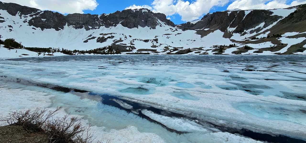
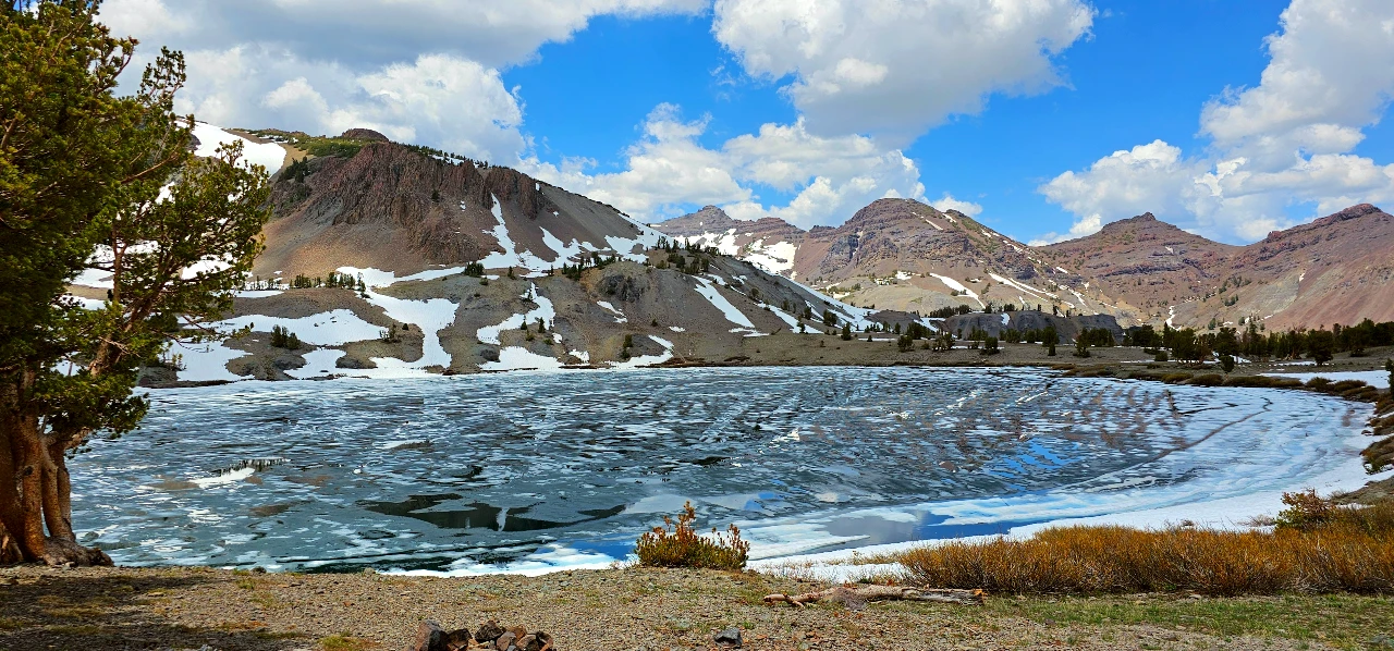
The final stretch of the road was buried in several feet of wet, slushy snow. But then the trees opened, and Leavitt Lake came into view—its waters half-frozen, ringed by alpine cliffs and shaded by high cornices above. The ice was breaking, leaving fractured reflections in pools of blue.

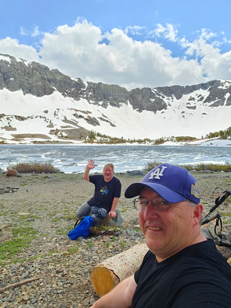
A lone fisherman greeted us. He had already caught a couple lake trout, and mentioned that his two hiking companions were circling the lake—taking selfies for social. They weren’t the only ones capturing the view. This place feels like a secret basin carved from glacier and snow, a stage set for alpine drama.
Perched in the Pines
We found a wind-sheltered seat among the stunted pines that circle the shoreline—twisted and tough from decades of surviving 20-foot snowpacks and howling ridge gusts. These trees are the elders of this place, shaped by freeze-thaw cycles and granite winds. Some barely reached shoulder height, their roots clinging to shallow soils between boulders. And still they stood—green, resilient, and offering us the best lunch spot in the Sierra that day.


The ridgeline to the south marked the Pacific Crest Trail’s crossing point; above us, the bowl still brimmed with snow. It felt untouched, like a sanctuary carved into the range’s spine. We sat for a long time. No agenda. No signal. Just sun, snow, stories, and the rhythmic clunk of my trekking pole as I dug into it for lunch.
Eventually, Tom stripped down and braved a polar plunge into the slushy lake, swimming briefly among the ice floes. It looked like something out of a high-alpine cocktail. I stayed dry—someone has to work the camera, right?
A Reminder: Leave No Trace Still Matters
After lunch, we wandered to the back of the lake—and the scene shifted. Stunning winter playground in full spring thaw, the meadows were awakening and as muddy as you would expect, adn the avalanche fields crackled up the canyon wall as the sun warmed the rocks. However, the melt-out revealed past visitors’ debris: old dirty socks, pull tabs, shoes, mylar balloons, fishing tackle, and broken camping gear seemed littered everywhere; we needed a large garbage bag or two. Come on, folks. This place deserves better. Whatever you pack in, pack it out. Always.
The Descent and the Long Way Down
I rarely take the same route back when traveling off-trail. We veered onto a new ridge shortly after leaving the lake—briefly lost the line—and had to backtrack to find a creek crossing. No harm. It’s just another excuse to linger in the high country. Two backpackers passed us, headed in for the night. They were overloaded, clearly struggling, but I envied them all the same. That night, they’d have the whole lake basin to themselves.
We spotted bubbling thermal features on the way out, but no hot spring pools. By the time we reached the truck, thunder rolled overhead and a light rain began to fall. The pass was saying goodbye.
We made a couple of scenic stops to photograph the snowmelt in motion, then rolled down the hill to Walker Burger for burgers and shakes—because what’s a Sierra day without one?
Final Thoughts: Why You Need to Hike Leavitt Lake
A hidden waterfall. A half-frozen alpine lake. A tough old tree. A cold plunge. A quiet trail and a hot burger at day’s end.
This is why we go.
I’ll be back later this summer with my dad’s Jeep. When that gate finally opens, Leavitt Lake will make for the perfect basecamp—no crowds, just stories waiting to be made.
The road will open soon, and vehicles will return—but if you can catch it on foot, before the gate swings wide, you’ll find the Sierra just as it’s waking up. And it just might wake something in you, too.
Related Posts:
- Hire a Pack Guide at Leavitt Meadow
- Best Spring Adventures in the Eastern Sierra
- Hiking Hoover Wilderness
- Three Days in the Hoover Wilderness- A great beginners backpack trip out of Leavitt Meadow


