Mammoth Lakes, CA — July 2025 | This weekend, the Mammoth Lakes community marks a milestone long in the making: the official opening of the Sherwin Trails Recreation Area, a vision nurtured since 2009 and now brought to life with a new paved trailhead, restrooms, and the first of many miles of planned trails at the base of the Sherwin’s.
A Beloved Backyard, Reimagined
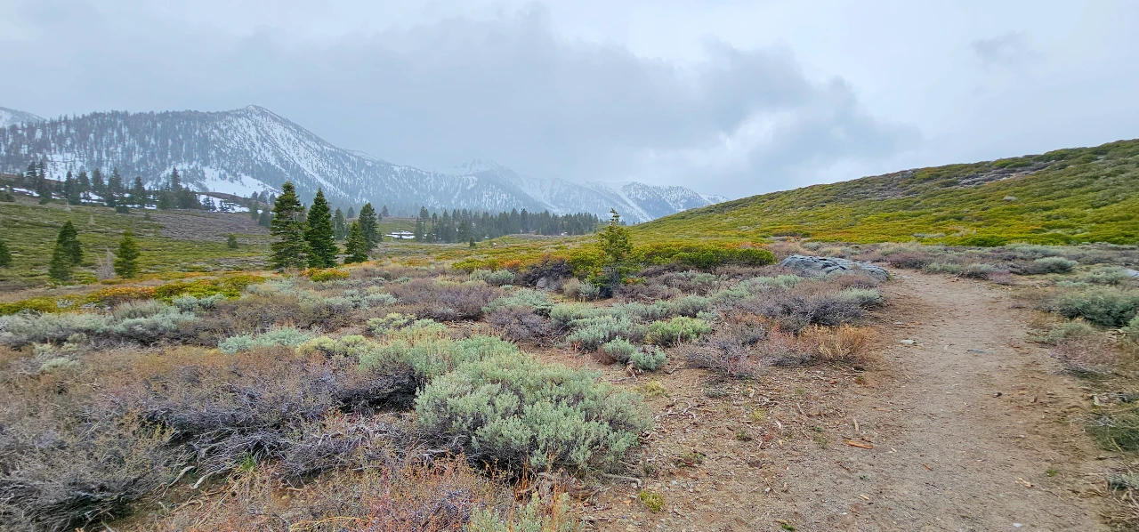
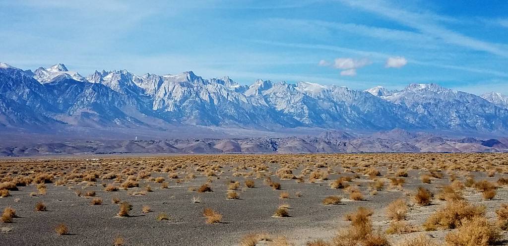
If you’ve ever wandered the sagebrush meadows below Mammoth Rock or climbed the dusty singletrack behind it, you know the Sherwins area is one of Mammoth Lakes’ most cherished front-country escapes. Locals and visitors alike have long flocked to these high desert hills year-round — from quiet hikes and bike rides under bluebird skies to backcountry ski laps leaving graceful tracks on winter slopes.

But that love, and the rising use over the years, has left its mark. A spiderweb of user-created trails had sprung up through sensitive alpine meadows, causing erosion and habitat damage that became too obvious to ignore. There were no formal trailheads or facilities, meaning ad-hoc parking in the “borrow pit” gravel lot and no restrooms or signage to manage the heavy recreation use. Clearly, the Sherwins deserved some TLC — and the community of Mammoth Lakes was determined to give it.
From Vision to Reality
The effort to better manage and enhance recreation in the Sherwins began over a decade ago. Back in 2009, local agencies and trail advocates formed the Sherwins Working Group and drafted the Sherwins Area Recreation Plan (SHARP) — a vision for sustainable trails and trailheads shaped by public input.
By 2022, the vision finally got the green light. In December 2022, Mammoth Lakes Recreation (MLR) secured two major grants from the Sierra Nevada Conservancy totaling $1.46 million:
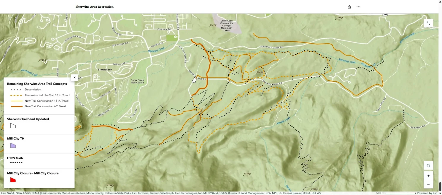
- A $510,000 planning grant for environmental analysis of roughly 20 miles of new trails and expanded trailhead.
- A $950,000 implementation grant to build the new Sherwin Meadows Trailhead with paved parking, double vault toilets, trash bins, and signage.
Years of outreach, environmental surveys, and community meetings laid the groundwork. By June 2025, the community’s patience paid off.
A New Trailhead for the Sherwins
On June 7, 2025, Mammoth Lakes Recreation, the Town of Mammoth Lakes, and Sierra Nevada Conservancy cut the ribbon at the Sherwin Meadows Trailhead.
What was once a dusty pull-out now boasts:
- Paved parking with ADA-accessible spaces
- Double vault toilets
- Bear-resistant trash cans
- New signage and kiosks
- A bike rack for riders rolling in on two wheels
No more squeezing onto the shoulder or ducking into the brush. The Sherwin Meadows Trailhead is a real gateway to adventure — and a clear example of what’s possible when a community steps up to steward the lands it loves.
From Ribbon Cutting to Stewardship
The opening ceremony wasn’t just symbolic. Over 35 volunteers stayed to kick off the “Summer of Stewardship” — picking up trash, lopping brush, dispersing native seeds, staining new trail signs, and installing the bike rack.
Just four days later, District Ranger Fred Wong signed the final Decision Memo for SHARP Phase 3, unlocking construction on the remaining trail network. The plan calls for closing old user-created “social” trails, restoring damaged areas, and building nearly 20 miles of sustainable, multi-use singletrack.
Trails for All Seasons and Users
The Sherwins trail network is designed for multi-use recreation: hikers, trail runners, mountain bikers, snowshoers, and backcountry skiers all share these trails. By realigning old unsustainable tracks and carefully siting new ones, the plan protects sensitive meadows, cultural resources, and fragile alpine soils.
In winter, the same routes double as skin tracks for backcountry skiing or mellow snowshoe loops with easy parking at the new trailhead. In summer and fall, they offer high desert vistas, blooming sage, and a quiet alternative to busier trailheads around town.

A Spring Hike: Mammoth Rock Trail Loop
I got a taste of the Sherwins revival this past spring during Fishmas Weekend — the official start of fishing season in the Eastern Sierra.
I started near the Mammoth Ice Rink, following Mammoth Creek past the historic Hayden Cabin, one of the oldest structures in town. The creek, alive with snowmelt, sang me along as I climbed a side canyon up to Sherwin Creek Road.
Crossing the fresh pavement of the new Sherwin Meadows Trailhead, I picked up the Mammoth Rock Trail, a classic singletrack that hugs the Sherwin Range’s steep flank. Sagebrush and Jeffrey pines lined my path, and Mammoth Rock loomed overhead like a stone sentinel.
Trail runners breezed past. A pair of mountain bikers cranked uphill, grinning at the view. The trail’s gentle grades and switchbacks made the climb feel just right — enough to get the heart pumping, but not punishing.
At the high point, near Old Mammoth Road, the forest closed in with cooler breezes from the higher lakes. I looped back down the Mammoth Rock Trail and out onto Sherwin Creek Road, tracing my steps to Mammoth Creek and the ice rink.
A perfect 5-mile sampler — and just the beginning of what’s possible when the new network is complete.
What’s Next
Over the next year, trail crews and volunteers will continue building out SHARP Phase 3:
- New trail segments linking meadows, ridges, and viewpoints.
- Restoration of unsustainable trails to protect wildlife and wetlands.
- Better signage and trail connections to town, the Lakes Basin, and beyond.
The Sherwins project is a community investment paid for by Measure R funds, Sierra Nevada Conservancy grants, and thousands of hours of local volunteer time. It’s a model for how Mammoth Lakes can balance growth with stewardship — and protect the places we love for the next generation.
Plan Your Visit
Trailhead: Sherwin Meadows Trailhead, off Sherwin Creek Road
Parking: Paved, free — please respect signage and closures
Facilities: Vault toilets, bear bins, bike racks, signage
Use: Hiking, running, biking, winter snow access
Respect: Stay on designated trails, pack out trash, keep dogs leashed
More Info & Maps: Sherwins Area Trails & Trailheads Story Map
See You on the Trail
If you’ve ever dreamed of wandering wide-open meadows under Mammoth Rock — now’s your chance. This new trail network is your invitation to rediscover a beloved backyard playground. Step lightly, breathe deeply, and if you’re local or just passing through, lend a hand in keeping the Sherwins wild and welcoming for all.
Happy trails, Mammoth.
📷 Photos by Sierra Rec Magazine — Mammoth Rock Trail, April 2025
Sources: Sherwins Area Trails Project – Mammoth Lakes Recreationmammothlakesrecreation.org; Sierra Rec Magazinesierrarecmagazine.com; Inyo National Forest press releasemammothlakesrecreation.org; Mammoth Lakes Trail System info mammothtrails.org.


