

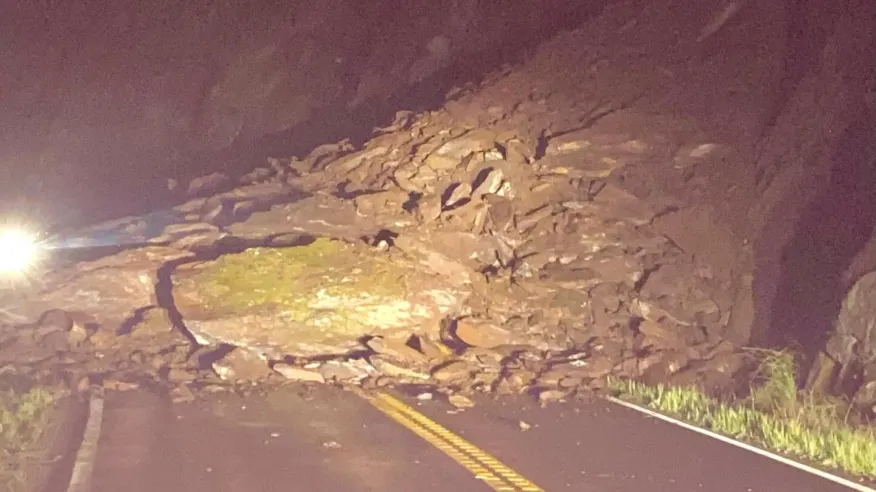
If you’re planning a trip to Yosemite National Park via State Route 140 out of Mariposa, you’ll need to adjust your route. Caltrans has issued a long-term full closure of SR-140 near Briceburg in Mariposa County due to a significant debris slide that occurred late Monday night, March 17, 2025.
March 26,2025 Update
#TrafficAlert Caltrans FULL CLOSURE remains in place on SR-140 from Briceburg to the Yosemite Cedar Lodge in #MariposaCounty due to a rockslide that occurred on 3/17/25. One-Way traffic ETO scheduled for tomorrow Wed. 3/26/25.
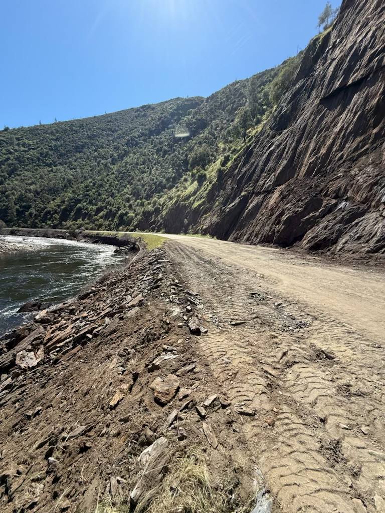
UPDATE (3/25): Caltrans & Teichert Construction continue to make great progress on clearing the debris and repairing the roadway in wake of the SR-140 rockslide.
Teichert Construction was able to finish the debris removal operations on Monday (3/24) and have started making repairs to the roadway today (3/25) in anticipation of re-opening SR-140 to one-way traffic control tomorrow afternoon (Wed. 3/26/25).
For real-time highway & closure information #KnowBeforeYouGo w. Caltrans QuickMap app on mobile devices or visit Quickmap.dot.ca.gov.
What Happened?
At approximately 10:00 p.m. on March 17, a large debris slide blocked both lanes of SR-140 near Briceburg. Overnight, the slide continued to shift, prompting Caltrans and the California Highway Patrol (CHP) to extend the closure for safety reasons. Officials are currently assessing the situation, but there is no estimated reopening date at this time.
Where is the Closure?
🚧 West of the slide: Road closed at Savage Trading Post in Briceburg
🚧 East of the slide: Road closed at Yosemite Cedar Lodge in Incline

How to Get to Yosemite Now
For visitors heading to Yosemite National Park, Caltrans recommends using alternate routes:
- State Route 41 (from Fresno) – through Oakhurst and Wawona entrance of Yosemite National Park
- State Route 120 (from Manteca) – Through Groveland and the North entrance of Yosemite National park near Hetch Hetchy Reservoir
- For Visitors in Mariposa County traveling along Highway 49 the Route from Coulterville to Route 120 is also accessible option.
These routes remain open and accessible for travelers heading to Yosemite, but be prepared for potential increased traffic due to detours.
Why This Matters for Travelers
This closure is significant because SR-140 is one of the main all-weather routes into Yosemite and is particularly popular due to its gradual elevation gain, making it a key entry point for RV travelers and those avoiding steep mountain roads. With this closure, visitors should allow for extra travel time and check road conditions before departing.
Stay Updated on Road Conditions
Caltrans will provide real-time updates through:
📍 Caltrans QuickMap: quickmap.dot.ca.gov
📍 Changeable Message Signs (CMS): Located along SR-41, SR-49, SR-99, and SR-120
📍 Social Media & Weekly Traffic Advisories
Plan Ahead & Stay Safe
Caltrans emphasizes that public safety is the top priority. Until the slide is cleared and the road is safe for travel, motorists should avoid this section of highway and seek alternative routes.
For those visiting Yosemite this spring, this is a great opportunity to explore alternative gateway towns such as Oakhurst (via SR-41) or Groveland (via SR-120) while still enjoying a spectacular adventure in the Sierra.
We’ll continue to monitor this situation and provide updates as soon as they become available. Stay safe and #KnowBeforeYouGo!


