
Three Hours of Snowshoe Wandering in Amador County
Bluebird days in the Sierra Nevada are hard to pass up, especially when the weekend arrives in The Carson Valley, our homebase for all our adventures at Sierra Rec. Living near Lake Tahoe has its perks—you don’t always need to plan far in advance or start at the crack of dawn to enjoy an adventure. This past Saturday, I woke to crystal-clear skies and knew most people would be heading to the slopes. Instead of joining the crowds, I decided to find a quiet spot for an afternoon snowshoe trek along Highway 88.

Finding Solitude on Highway 88
Weekend traffic on Highway 88 is a mix of bustling hotspots and quiet stretches of solitude. Since I was heading out late in the day, I knew flexibility would be key to finding the peaceful adventure I was craving.
I left home around 12:30 PM—later than my usual start time—but I wasn’t going to stress about it. This day was about enjoying the moment. I picked up my hiking and snowshoeing companion, Tom, and we set off up Highway 88. I gave him a few route options, and he encouraged me to seek out an unfamiliar destination. He knows I love the thrill of the unknown. Still on 88 there are so many old favorites, I was prepared to go just about anywhere.
Exploring Alpine County
Arriving in Alpine County, it was clear we weren’t alone in our desire to be outdoors. Known for its quiet escapes, Alpine County can still get busy on a perfect Saturday. As we passed the Blue Lakes winter recreation area, we saw the snowmobile community was out in full force. Even with winter Parking passes required, it is sometimes surprising how many people congregate in single locations when there are so many options. Still hard to deny the Blue Lakes winter recreation area with its groomed access.
One pleasant surprise was the number of roadside parking spots plowed by CalTrans. During lighter snowfall years, they have more time to clear extra areas for recreationists. However, driving past Red Creek, we also noticed that snowfall in Hope Valley was below average—sagebrush and willows, typically buried by this time of year, were still poking through the snow. I decided to continue deeper into the Sierra in search of better conditions.
Past Kirkwood and Toward Silver Lake
We crossed Carson Pass and the Sierra Crest, passing the heavily trafficked trailheads near Winnemucca Lake. As we descended toward Caples Lake and Kirkwood Basin the snow depth started to improve however, the number of parked cars was staggering—skiers were walking down the road from as far out as the Caples Lake Dam. Seeing the sheer number of people, I commented to Tom, “If I were a skier, I’d be a permanent backcountry guy. The community is great, but the crowds—just wow.”
As we climbed out of Kirkwood Bowl into the Silver Lake region, roadside crowds began thinning. I set my sights on a parking area near Tragedy Springs just up the ridge above Silver lake, but when we arrived, it was full of snowmobile trailers and vehicles. At that point, an hour into our drive, we turned back to Shealor Lake’s pull-out just down the ridge back towards the Silver Lake bridge, which had just enough space for a couple of cars. It’s rare to find this spot plowed in winter—an unexpected but welcome opportunity.

Snowshoeing Shealor Lake
I hadn’t been to Shealor Lake in years, not since the devastating fire that scorched this part of the Eldorado National Forest. I was eager to rediscover it. Before the fire Shealor Lake was a hidden gem for easy backpacking get-aways for individuals looking for tee lined lakes and moderate to easy climbs. The moderate climb to the ridge promised stunning views, and the deeper snow in this area, untouched by other visitors, added to the anticipation. If we choose to go all the way to the lake the trail is only about 2 miles in distance, but will require us to crawl over a short pass and then down a granite slope to the lakes. We will see what conditions are like when we arrive at the top.
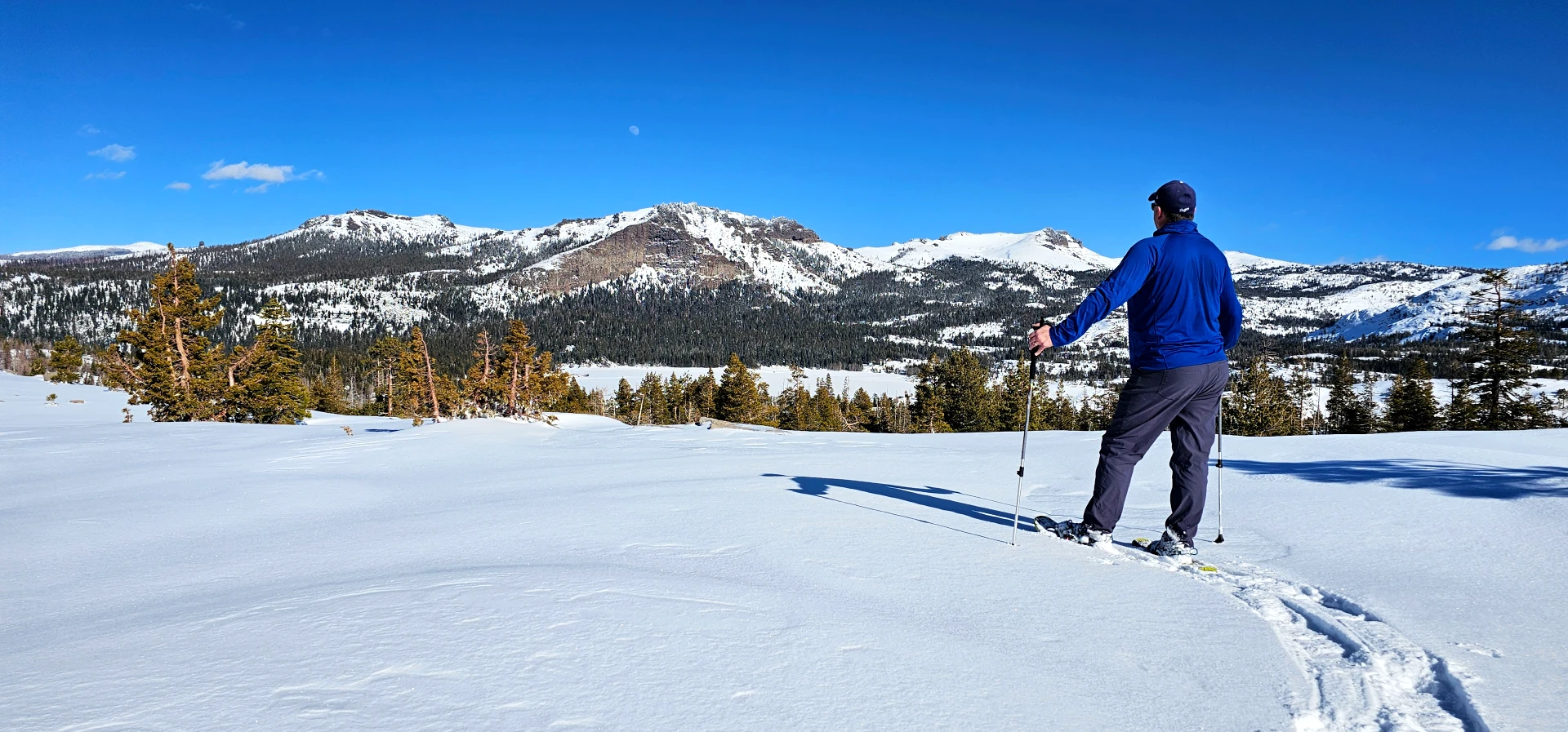
We strapped on our MSR snowshoes and layered up for the trek. This winter I have been playing around with layering trying to find the right mix for my body temp. Today with the weather I choose a simple Merino Wool t-shirt followed up by a new favorite of mine the Alpine Onset Merino 150 Hoodie by Outdoor Research. This ended up being the perfect layer for todays temps and I never had to pull out my puffer from the bag for warmth. The fresh powder and towering snowbanks gleamed under the blue sky. At 1:30 PM, we had several hours before sunset to explore.


Without a defined trail to follow, I navigated by memory and instinct, considering slope angles, avalanche awareness, and scenic appeal. The trail from the parking area heads Northeast back towards Silver Lake before curing around the hillside to the pass. The climb to the ridge was about a mile with 350 feet of elevation gain—a gentle ascent that we took at a leisurely pace. Beneath the powder two inches of powder, we encountered a thick ice crust, a reminder of the recent avalanche warnings. While our chosen route was low-risk, I remained mindful of the conditions.
Wildlife Encounters and Hidden Signs
Along the way, we crossed a solitary set of coyote tracks—proof that wildlife still thrives here in winter. Soon after, we found wild hare tracks, likely a food source for the coyote. As we emerged from the forest for the final climb, we spotted a second set of coyote tracks, possibly indicating a hunting pair working in tandem. I for one love seeing signs of wildlife when I am out. It takes me back to the days of hunting for wildlife in the winters with my father as he tried to hone his skills as a wildlife photographer.


The final ridge ascent was tricky—wind exposure had hardened the ice left it exposed with no cover in many locations, making footing more precarious. Carefully, we advanced up between two small peaks, finally reaching the breathtaking Shealor Lake vista. Even with the burn scars from the fire, the view across the Eldorado National Forest was spectacular. It is obvious from here that the trek down to Shealor lake would be tricky, and probably a little to risky for us today, so we traveled along the ridge to the North for some time just taking in the view and enjoying the solitude.
A Mysterious Sound in the Wilderness
One of the great things about adventuring with Tom is our mutual appreciation for solitude. As we trekked, I took a moment to separate and enjoy the mountain’s peaceful silence along the ridge. Strangely, I kept hearing a faint scraping sound from the ridge but couldn’t pinpoint the source. Was it a coyote? A hidden campsite? The mystery lingered as we explored further.

Choosing Our Own Path
Standing atop the Shealor Lake pass, we were treated to a panoramic 360-degree view. To the northwest, we could see Echo Summit. Below us, the frozen expanse of Shealor Lake stretched out. However, an unusual ice formation on a granite hillside to the west caught our eye. This is what I love about backcountry snowshoeing—the ability to forge your own adventure. Every outing is a blank canvas, shaped by curiosity and choice. So we turned around after drifting north a bit and headed back over to the South west corner of the ridgeline towards the Ice.
We descended into a draw and climbed toward the ice formation—a frozen cascade draped over the granite, with a hollow cavity forming behind its crystalline curtain. Tom, always excited by rare natural features, was in his element. I took notice of several old trees an the different ways that the trees fight for survival on the granite. several trees showing networks of root systems above the snow and a variety of odd shaped trees from years of battle they face with annual snowpack. After admiring the formation, we began looping back toward our starting point, taking another ridge to the east.
The Mystery Revealed
As we neared the top of the ridge, the source of the strange sounds herd earlier became clear—a lone backcountry skier had traversed behind us and ascended a parallel ridge, carving a solitary line down the slope back towards where we had come through the forest earlier. It was an elegant and isolated run with spectacular views over silver Lake and Thunder Mountain in the backdrop. I had no idea where he had come from, but I instantly admired his choice to embrace the backcountry’s solitude.
The Final Descent

Following his ski tracks for a while, we then veered off-trail once more, venturing into a pristine draw. The trees were still cloaked in snow and ice from the last storm, and the untouched landscape beckoned us forward. Eventually, we climbed out of the draw near our original path, making the retracing of our initial route easy, and arrived back at the truck.
In total, we covered just over two miles with 350 feet of elevation gain. Though a relatively short trek, we took our time and soaked in the experience, enjoying three hours of serene beauty, fascinating wildlife signs, and friendly conversations about ice formations and coyotes. This trip was a perfect reminder that the simple joys of the Sierra—the tracks in the snow, the panoramic vistas, and the quiet moments of wonder—are what make these adventures truly special.
Gear Used on this Adventure
- MSR Lightning Explore Snowshoes – These shoes with the new Paradigm™ Binding are fantastic.
- Alpine Onset Merino 150 Hoodie by Outdoor Research– Lightweight Warm and comfortable Hoodie mad ethe perfect mid layer
- York Nordic Two Section Hiking sticks – These are by far my favorite Hiking sticks. this old 10 year old pair have out lasted all the other options. And Perfect for treks like this.
- Tart Cherry Cacao Nutrition Squeeze by Neve – A new snack for after trail experiences. Tastes like Cherry flavored Chocolate Mouse. YUM!
- Merino Wool Ski Socks by Outdoor Masters – I picked these up for winter 2024-25 and love these new compression socks.
- Columbia Men’s Bugaboot™ III Boot – Feet are warm and dry on every snowy adventure. The ankles are stiff, which are not my favorite, but I can believe how warm and dry they are in powder and wet snow.
- Osprey Day Pack – I have had this day pack for a couple years now. Perfect size for dayt trips int he Sierra


