

Ebbetts Pass is more than just a scenic drive; it’s a portal to some of the Sierra Nevada’s most pristine wilderness and day trip adventures. With its towering peaks, crystal-clear lakes, and winding trails, this iconic pass offers exceptional backpacking experiences that deliver on the quality solitude sought by most. A great place to target for 1-3 day pack trips we love to connect with the PCT and several Wilderness access points while exploring this region for a quick and easy get a way.
Let’s explore some of the best treks this region has to offer.
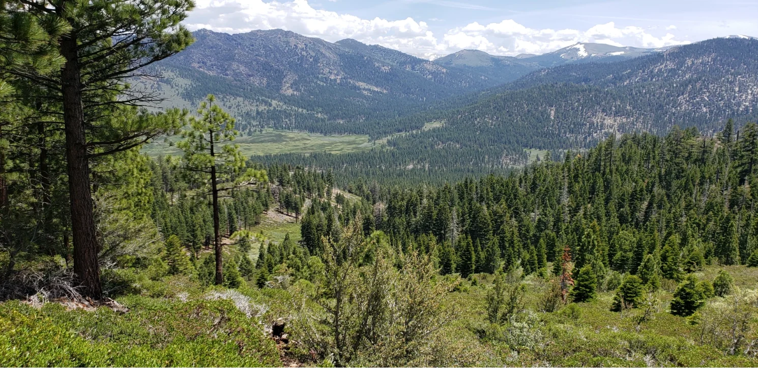
Immerse Yourself in the Carson-Iceberg Wilderness
To the south of highway 4 lies the serene wilderness solitude within the Carson-Iceberg Wilderness. This protected expanse is a haven for hikers seeking solitude and natural beauty. We often find days in the Carson Iceberg Wilderness filled with wildlife and solitude. Fewer people to spread out across its river canyons and peak. Wolf Creek Access and High Country trail routes off the Ebbett’s Pass drop backpackers in to lush meadows, stunning lakes and canyons carved by extreme weather. here are a few of the most popular backpacking trips from the Ebbetts pass side of Carson Iceberg wilderness.
Horse Meadow
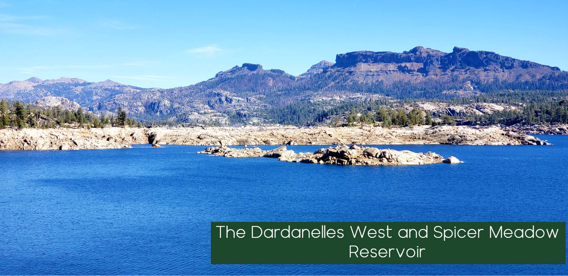
Trailhead: Spicer Meadows Reservoir
Distance: 6 miles one way (12 miles round trip)
Elevation Range: 6,400′ – 7,100′
An unforgettable adventure through the rugged beauty of the Carson-Iceberg Wilderness Horse Meadow offers spectacular views of the Dardanelles and the Middle Fork of the Stanislaus River Canyon.
Trail Description
Starting at the trailhead by the Spicer Reservoir dam, the journey begins with a steady ascent. As you climb, you’ll traverse through a variety of landscapes, including pine forests and rocky outcrops. The trail soon leads you over a saddle near Whittakers Dardanelle, where the first breathtaking views of the surrounding wilderness unfold. From this vantage point, the vistas of the Dardanelles and the Middle Fork of the Stanislaus River Canyon are simply awe-inspiring.
Descending from the saddle, you’ll find yourself in Wheats Meadow, a serene and expansive area ideal for a quick rest or picnic. Continue southward, following the trail as it winds towards Horse Meadow. Along the way, you’ll be treated to ever-changing scenery, from dense woodlands to open fields adorned with wildflowers, depending on the season.
Arriving at Horse Meadow, you’ll discover an idyllic camping spot nestled amidst the wilderness. The meadow provides ample space for tents, and nearby high points offer striking views of the Stanislaus River Canyon and the sparkling waters of Donnell Reservoir. The evenings here are particularly magical, as the setting sun casts a warm glow over the landscape, creating a perfect backdrop for a peaceful night under the stars.
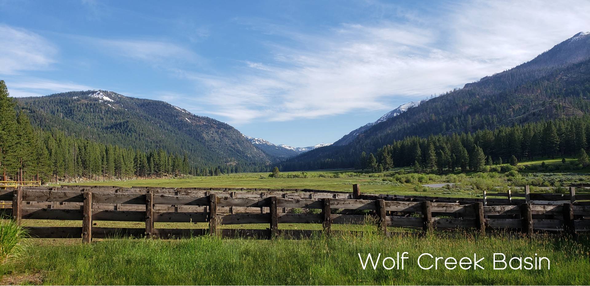
Wolf Creek Loop: A Three-Day Wilderness Adventure
Trailhead: Wolf Creek
Distance: 23 miles
Elevation Range: 6,500′ – 8,000′ – 6,600′ – 8,800′ – 6,500′
We love the Wolf Creek drainage and high loop combination. A highly underrated section of the Sierra Nevada. The Wolf Creek Loop Starts at the Backside of a large meadow and climbs up into another large meadow before and incredible Vista views along the trail . This scenic trail offers a blend of high ridges, lush valleys, and cascading waterfalls, making it an ideal adventure for backpackers looking to experience the beauty of the Eastern Sierra.
Trail Description
Day 1: Wolf Creek to Dumonts Meadows (8 miles)
The adventure begins at the Wolf Creek trailhead, where you’ll start on the High Trail. The initial climb takes you up a ridge, offering sweeping views of the surrounding mountains. As you traverse the ridge, the trail gradually descends into the picturesque East Fork of the Carson River Valley. The day’s hike ends at Dumonts Meadows, where the trail crosses the river. This tranquil spot is perfect for setting up camp, with the soothing sounds of the flowing river as your evening soundtrack.
Day 2: Dumonts Meadows to Murray Canyon (8 miles)
On the second day, continue upstream along the East Fork of the Carson River. A highlight of the day is a mile-long detour to Carson Falls at Falls Meadow. The hike to the falls offers a refreshing break and the chance to enjoy the stunning waterfall up close. After returning to Falls Meadow, follow the main trail as it ascends through Murray Canyon. The climb involves a series of switchbacks, rewarding you with panoramic views as you gain elevation. It’s important to avoid any side trails heading south to stay on course. As the trail descends back towards Wolf Creek, you’ll find ample spots to set up camp for the night.
Day 3: Murray Canyon to Wolf Creek Trailhead (7 miles)
The final day takes you along the beautiful Wolf Creek. The trail gradually descends, following the creek’s gentle flow. The route is mostly downhill, making for a pleasant and relaxed hike back to the trailhead. Enjoy the diverse flora and fauna along the way, as well as the peaceful ambiance of the creek.
Epic Thru-Hikes: Ebbetts to Beyond
Of Course the central hub of the Ebbett’s Pass highlands is the PCT. Ebbett’s offers a unique experience that easily splits two segments of the PCT into great weekend experiences, for those seeking a longer challenge, consider these epic journeys:

Ebbetts Pass to Sonora Pass: A High Sierra Adventure
Trailhead: Ebbetts Pass
Distance: 26 miles
Elevation Range: 8,100′ – 10,500′
Experience the grandeur of the High Sierra on this exhilarating three-day trek from Ebbetts Pass to Sonora Pass. This journey along the Pacific Crest Trail (PCT) traverses stunning alpine landscapes, crossing ridges and valleys, and offering breathtaking views at every turn. This route requires setting up a shuttle, with one car parked at either Sonora Pass or Ebbetts Pass, depending on your starting point. The landscape of this section of the PCT is often described as Rugged, scenic and wild.
While beginning at Sonora Pass provides an easier climb due to the higher starting elevation, this description starts at Ebbetts Pass, providing a gradual introduction to the trail’s challenges and rewards.
Trail Description
Day 1: Ebbetts Pass to Wolf Creek (7 miles)
Beginning at the PCT parking lot at Ebbetts Pass, hikers will set out southward into a remote and unique section of the Sierra. The trail winds through the Carson-Iceberg Wilderness, where granite ridges and volcanic peaks define the landscape. The area can hold snow well into summer, adding a stark contrast to the colorful wildflowers that splash the terrain. As you climb towards the ridge near Tryon Peak, you’ll traverse a largely treeless landscape with fragmented cliffs and slopes of volcanic rock, providing awe-inspiring views over snow-streaked peaks and verdant valleys below. Upon descending, you will reach the serene Wolf Creek, an ideal campsite for your first night.
Day 2: Wolf Creek to East Carson River Canyon (11 miles)
The second day brings an ascent past Disaster Peak, where hikers will notice the geological transition from granite to volcanic rock formations. The trail circles the head of Golden Canyon, descending gradually into the East Fork Carson River drainage. As you descend, you’ll re-enter pine forested areas, with small streams and potential campsites dotting the route. Look out for the fascinating dome of dark basalt crowning a white-rock ridge, a testament to the volcanic activity that shaped this region. The day concludes in the East Carson River Canyon, where the peaceful river and surrounding meadows offer a perfect camping spot.
Day 3: East Carson River Canyon to Sonora Pass (8 miles)
On the final day, the trail climbs steadily towards the shoulder of Sonora Peak. At around 10,500 feet, you’ll be treated to sweeping panoramic views of the surrounding Sierra landscape. The ascent may include some steep snow crossings, depending on the season. As you near Sonora Pass, the trail becomes more rugged, contoured along weathered volcanic slopes. The path alternates between curving around valleys and crossing mountain gaps, showcasing a blend of stark geology and vibrant subalpine flora. Notable water features along this stretch include small streams and alpine lakes like Noble Lake, offering refreshing spots to rest and take in the scenery. However, remember to camp at least 100 feet away from any water source.
The segment concludes at Sonora Pass, where the trail crosses State Route 4. This remote and scenic area offers a less frequented access point to the trail, making it a unique experience for section hikers. The surrounding wilderness and the challenging yet rewarding terrain make this section a memorable part of the PCT journey.

Ebbetts Pass to Carson Pass: A Journey Along the Northern Sierra Crest
Trailhead: Ebbetts Pass
Distance: 24 miles
Duration: 3 Days
Elevation Range: 8,800′ – 7,800′ – 9,000′ – 8,600′
The hike from Ebbetts Pass to Carson Pass along the Pacific Crest Trail (PCT) offers a relatively gentle yet scenic journey through the Northern Sierra. Unlike the more rugged section to Sonora Pass, this route features moderate ups and downs, with the most significant climb being only 1,200 feet. The trail winds through beautiful alpine lakes, rugged peaks, and lush meadows, making it a delightful trek for backpackers seeking a three-day adventure. A Quick overnighter for families is from Ebbetts to Upper Kinney Lake.
Trail Description
Day 1: Ebbetts Pass to Wet Meadows Reservoir (11 miles)
Begin your journey at the trailhead parking lot at Ebbetts Pass. From here, take a short side trail to join the PCT and head north. The trail quickly crosses Highway 4 and continues past the serene Upper Kinney Lake, a great spot for a quick rest or photo. As you proceed, the trail traverses the rugged shoulders of Reynolds and Raymond Peaks, offering stunning views of the surrounding landscape.
For an early camping option, consider Pennsylvania Creek. However, if you’re up for a longer first day, continue on to Wet Meadows Reservoir, covering a total of 11 miles. This area offers ample camping opportunities in a picturesque setting, surrounded by lush meadows and forested slopes. Also there is a side route to a very windy of fishers haven at Raymond Lake.
Day 2: Wet Meadows Reservoir to Lost Lakes (7 miles)
The second day starts with a trek through the scenic Blue Lakes area. Here, you may encounter more hikers and even a few cars, as the area is more accessible. Despite the presence of others, the beauty of the Blue Lakes area is undeniable, with clear waters reflecting the surrounding peaks.

Continue your journey with a significant climb towards Lost Lakes. This 7-mile section includes a challenging ascent, but the effort is well worth it. Lost Lakes provides a tranquil and secluded campsite, with stunning views of the surrounding alpine landscape.
Day 3: Lost Lakes to Carson Pass (6 miles)
On the final day, the trail descends gently through Forestdale Creek, offering a more relaxed pace after the previous day’s climb. The route meanders through beautiful meadows and forested areas, with occasional glimpses of distant peaks. The hike concludes with a gradual ascent to Carson Pass, where you’ll find a visitor center and parking area, marking the end of this scenic journey.
Additional Highlights and Notes
- Golden Trout at Raymond Lake: While possibly more legend than fact, the golden trout of Raymond Lake adds a layer of local intrigue and curiosity. This rare species, reputedly present in the lake, is a point of interest for those who enjoy fishing or are simply fascinated by regional folklore.
Family-Friendly Adventures
Not all backpacking trips require days of strenuous hiking. Ebbetts Pass also caters to families and less experienced hikers:
Bull Run and Heiser Lakes: A Family-Friendly Backpacking Adventure
Trailhead: Stanislaus Meadow
Distance: 9 miles round trip
Elevation Range: 7,400′ – 8,400′ – 7,900′ – 8,400′
Location: Carson-Iceberg Wilderness
Trail Overview
The hike to Bull Run and Heiser Lakes is a gentle and scenic adventure, perfect for families and those looking for a short yet rewarding backpacking trip. Nestled within the Carson-Iceberg Wilderness, this trail offers beautiful mountain lakes ideal for camping, swimming, and fishing. The manageable distance and moderate elevation changes make it an excellent choice for introducing children to the joys of backpacking.
Trail Description
Day 1: Stanislaus Meadow Trailhead to Heiser Lake (5.5 miles)
The journey begins at the Stanislaus Meadow Trailhead, located 4.5 miles east of Lake Alpine. The trail descends slightly to cross the Stanislaus River, where you can enjoy the serene sound of flowing water. As you continue, the trail climbs gradually to Bull Run Lake, a beautiful alpine lake nestled at 8,400 feet. This 3-mile stretch offers an excellent opportunity to enjoy lunch by the lakeside, surrounded by stunning views of Bull Run Peak and the surrounding wilderness.
After a relaxing break, retrace your steps for about a mile until you reach the junction with the Heiser Lake trail. Follow this trail to Heiser Lake, approximately 5.5 miles from the trailhead. The lake is a peaceful spot for setting up camp, with ample space to relax and explore. The area around Heiser Lake offers a scenic backdrop, with Bull Run Peak towering above. For those interested in a short additional hike, a nearby trail leads to the rim of Pacific Valley, providing breathtaking vistas of the valley below.
Day 2: Heiser Lake to Stanislaus Meadow Trailhead (4 miles)
On the second day, take your time packing up and enjoying the tranquility of Heiser Lake. The return journey retraces the previous day’s route, covering 4 miles back to the Stanislaus Meadow Trailhead. The descent offers a pleasant and leisurely walk, perfect for taking in the sights and sounds of the wilderness.
Activities at the Lakes: Both Bull Run and Heiser Lakes offer opportunities for swimming and fishing. The clear, cold waters are inviting for a refreshing dip, while fishing enthusiasts may enjoy casting a line in the hopes of catching some of the area’s trout. Scenic Views and Wildlife: The trail provides plenty of chances to enjoy the natural beauty of the Carson-Iceberg Wilderness. Keep an eye out for local wildlife, including deer, birds, and small mammals. The trail’s relatively low traffic enhances the experience of solitude and connection with nature.

Spicer Meadow Reservoir Loop: A Scenic Backcountry Adventure
Trailhead: Summit Lake
Distance: 17 miles
Duration: 2 Days
Elevation Range: 7,000′ – 6,400′ – 7,100′ – 6,400′
Trail Overview
The Spicer Meadow Reservoir Loop offers a picturesque and varied backcountry experience, ideal for those looking to explore the serene beauty of the Sierra Nevada. This 17-mile loop is best tackled by leaving one car at the trailhead near the Spicer Meadow Reservoir dam and starting the hike from the Summit Lake Trailhead. The trail traverses diverse landscapes, including alpine lakes, meadows, and creek crossings, making it a rewarding adventure for hikers seeking a blend of solitude and natural beauty.
Trail Description
Day 1: Summit Lake Trailhead to Sword and Lost Lakes (9 miles)
Begin your journey at the Summit Lake Trailhead, where the trail crosses Wilderness Creek and descends to the upper shore of Spicer Meadow Reservoir. This peaceful section of the reservoir is motor-free, providing a quiet and undisturbed environment. As you circle the upper end of the lake, you’ll encounter Highland Creek, a great spot for a mid-day break or camping at mile 6. The area offers beautiful views and ample opportunities for fishing and relaxation.
For those looking to extend the day’s hike, continue on to Sword and Lost Lakes, located about 3 miles further. These secluded alpine lakes, nestled amid rugged terrain, offer excellent camping spots with stunning views. The total distance for the day is approximately 9 miles, making it a satisfying and scenic day of hiking.
Day 2: Sword and Lost Lakes to Spicer Meadow Reservoir Dam (8 miles)
The second day begins with a descent from Sword and Lost Lakes into the picturesque Dardanelle Creek area. The trail then crosses a low ridge to reach Wheats Meadow, a lush and expansive meadow that offers another potential camping spot for those who might want to break the hike into three days. From Wheats Meadow, the trail climbs 500 feet over another ridge, providing panoramic views of the surrounding wilderness.
The final stretch leads back down to the Spicer Meadow Reservoir dam, completing the loop. This section offers a mix of forested paths and open meadows, providing a pleasant and varied end to the hike.
Additional Highlights and Notes
- Alternative Cross-Country Route: Experienced cross-country hikers may opt for a more direct route from Sword and Lost Lakes, bypassing the detour to Dardanelle Creek and Wheats Meadow. This alternate route shortens the loop by approximately 3 miles and offers a more adventurous, off-trail experience.
As you prepare for your backpacking adventures off Ebbetts Pass, it’s crucial to be aware of essential considerations and wilderness ethics. Whether you’re exploring the serene Bull Run and Heiser Lakes, trekking from Ebbetts to Sonora Pass, experiencing the Spicer Meadow Reservoir Loop, or any other enchanting route, these tips will help ensure a safe, enjoyable, and respectful journey.
Wilderness Permits
All the trails discussed, including those in the Carson-Iceberg Wilderness, require wilderness permits for overnight stays. These permits help manage visitor impact and preserve the natural beauty of the area. Permits can be obtained through the Stanislaus National Forest ranger stations or online. Be sure to check for any specific trail conditions, fire restrictions, or additional guidelines before setting out.
Leave No Trace Principles
The unique and fragile environments you’ll encounter around Ebbetts Pass deserve our utmost respect. To minimize your impact and protect these pristine landscapes, please follow the Leave No Trace principles:
- Plan Ahead and Prepare: Know the rules and special concerns for the areas you’ll visit. Prepare for varying weather conditions and possible emergencies.
- Travel and Camp on Durable Surfaces: Stay on established trails and use designated campsites. Keep camps at least 100 feet away from lakes and streams to protect water quality.
- Dispose of Waste Properly: Pack out all trash, leftover food, and litter. This includes organic waste like orange peels or sunflower seed shells.
- Leave What You Find: Preserve the natural and cultural features of the wilderness. Leave rocks, plants, and other natural objects as you find them.
- Minimize Campfire Impact: Where campfires are permitted, use established fire rings, keep fires small, and burn only small sticks from the ground. Consider using a portable stove instead.
- Respect Wildlife: Observe animals from a distance and never feed them. Protect wildlife and your food by storing rations and trash securely.
- Be Considerate of Other Visitors: Respect other visitors and protect the quality of their experience. Yield to other users on the trail and maintain a quiet camp.
An Enchanting Invitation
The trails off Ebbetts Pass offer a gateway to some of the most enchanting landscapes in the Sierra Nevada. From the rugged volcanic peaks and granite ridges to the tranquil alpine lakes and verdant meadows, each trail offers a unique window into the natural beauty of the region. The diverse flora and fauna, including vibrant wildflowers, ancient pine forests, and a variety of wildlife, create a dynamic and captivating environment.
These trails also provide a rare opportunity for solitude and introspection. Whether you find yourself amidst the expansive views from Sonora Peak, the quiet shores of Sword and Lost Lakes, or the lush meadows near Heiser Lake, the serenity and isolation of these areas offer a perfect escape from the everyday world. The whispers of the wind through the trees, the distant call of a bird, and the silent grandeur of star-filled skies all contribute to a profound sense of peace and connection with nature.
Embark on these journeys with an open heart and a respectful spirit, ready to embrace the wonders of the wilderness. The trails off Ebbetts Pass are more than just paths through the mountains—they are invitations to discover a landscape of breathtaking beauty, rich history, and deep tranquility. As you hike these trails, you will not only explore the Sierra’s unique volcanic and alpine environments but also forge unforgettable memories of adventure and discovery. Enjoy the journey, and may the wilderness inspire and rejuvenate you.
Important Considerations
- Permits: Many of the trails in this area require wilderness permits. Be sure to obtain the necessary permits before your trip.
- Wildlife: The Sierra Nevada is home to a variety of wildlife. Practice Leave No Trace principles and store food properly to avoid encounters.
- Weather: The Sierra’s weather can be unpredictable. Check the forecast before your trip and be prepared for changing conditions.
Whether you’re a seasoned backpacker or a novice hiker, Ebbetts Pass offers something for everyone. With its stunning scenery, diverse trails, and opportunities for adventure, it’s a destination that will leave you longing for your next visit.


