There are many different ways to spend a 4th of July holiday in America. For the past two years I have choose to spend most of the day by myself on a solo hiking experience in Yosemite National Park. This year I chose to explore one the furthest east trail experiences and to discover more about the region where Ansel Adams wilderness and Yosemite meet high in the Sierra.
Unlike 2019 when the park was fully open and expectations were that was likely not going to be in seclusion much of the day on the JMT as I traveled Lyell Canyon. This year I figured that limited access crowd controls of Covid-19 pandemic besides the fact that this just did not seem like the most sought out set of trail location could provide me with a good amount of seclusion for the day. It was certain to provide me with new perspective of this Eastern rim of the park and visual contrast between the towering granite of Yosemite and the colored sediment rocks of the Ansel Adams Wilderness on this boarder. My goal for the day was to climb to both Mono Pass and Parker Pass with brief excursions into Ansel Adams Wilderness to see a set of lakes close to the boarder of both. Unlike last year when i hung the hammock and napped along the river, this year I carried the hammock, but had ambitious goals on what I want to see so setting up a hammock may not be in the cards.
I set out at 6:30 am for the Carson Valley knowing that on a standard day at the Tioga Pass entry gate I could be parked and starting to hike with in the next 2.5 hours. To my delight the gates were not backed up and I was able to access Yosemite based on my Reservation with in a minute of approaching the gate.
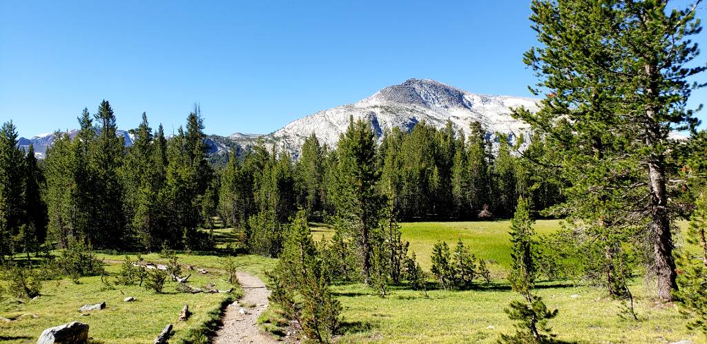
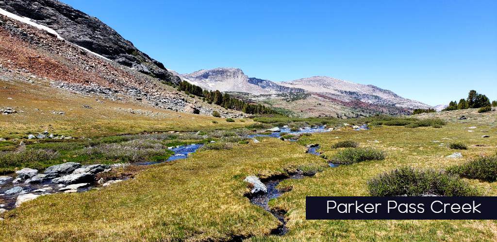
Mono Pass/ Parker Pass trailhead is located in the first few miles of the parks gates set in a densely populated forested area providing a preview of what most of the first section of today’s adventure would feel like as you stroll upwards through forested meadows and stream crossings. The Mono Pass Trailhead sits at roughly 9,500 feet and on the days trek we will reach peak elevations of 11,100 feet at Parker’s Pass. The Tree cover is prevalent through the first 3 miles of the trail before bursting out of the trees into high alpine meadows leading up to the lakes on top. Along the trail you are given options at 1.8 miles to split up to Mono Pass or veer up to Spillway lake which lays below Parker Pass to the West. If you choose the Mono Pass route as we did on our journey, you are again offered a split about .3 miles from the top of Mono Pass to Parkers Pass which is another 1.7 miles.
Mono Pass
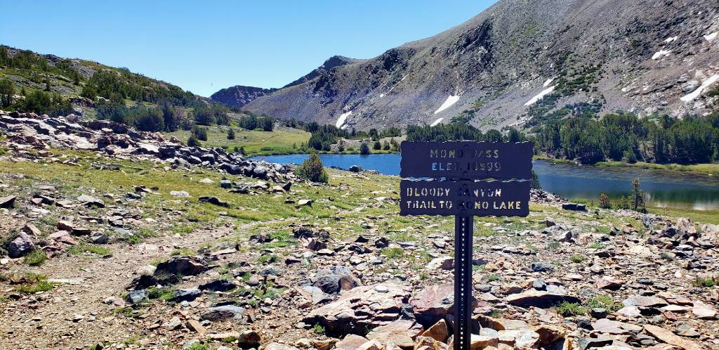
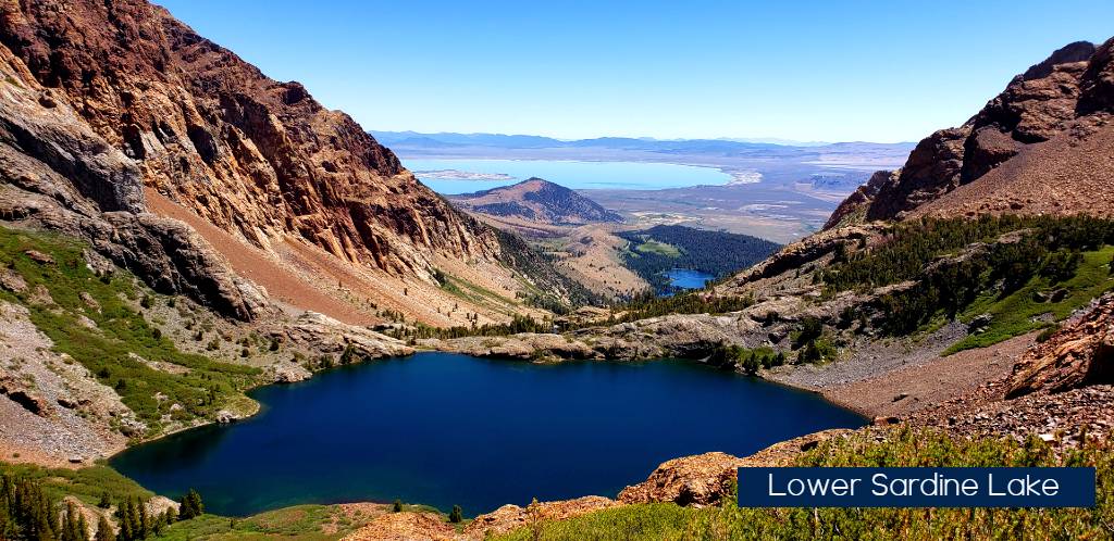
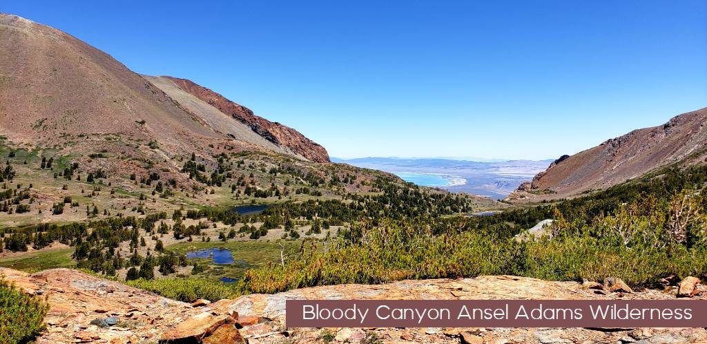
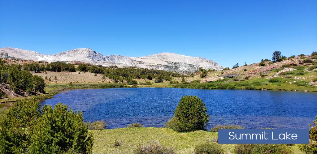
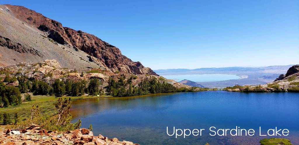
Mono Pass sitting at 10599′ is the gateway to Bloody Canyon trail to Mono Lake. It will lead you beside Summit Lake, Upper and Lower Sardine Lakes in the Ansel Adams Wilderness and on into Walker lake and Mono Lake basin. Here the Lush meadows that race into Yosemite High country flush with flowing water and green grass, give way to a rough and colorful landscape that brings to mind the very image of dry and desolate. The landslide mountain slopes of Mount Gibbs and Mt Lewis stand as towering gateways to Mono Basin and a stark contrast to the Granite towers of the Kuna Crest to the West of these meadows. Just below Summit Lake stands a set clear water lakes great for backpacking and fishing in Upper and Lower Sardine Lakes. Travelers over the Pass down to these lakes are also introduced to one of the iconic vista views of the Eastern Sierra with Mono Lake and its oddly colored blue waters dominating the horizon.

Backpacking into Sardine Lakes can be done from Walker Lake trail area with a rating as difficult as the climb is close to 3000 ft elevation gain to the upper lake in approximately 3-3.5 miles. I saw one Tent at Upper Sardine Lake that had the entire basin to themselves for the 4th of July Weekend, besides us Day hikers pooping in for a few pictures. I would think Since Camping is not allowed on the Yosemite side of Mono Pass that this is a popular choice for backpackers coming from Yosemite who would like to stay for a few days up in these mountain lakes. Additional Permits would probably need to be acquired from Inyo National Forest for staying in Ansel Adams Wilderness.

Parker Pass
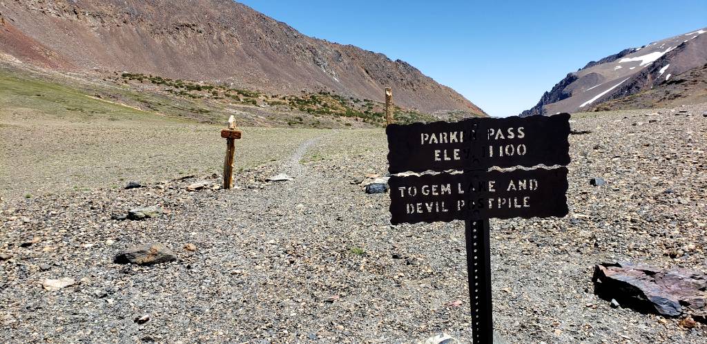
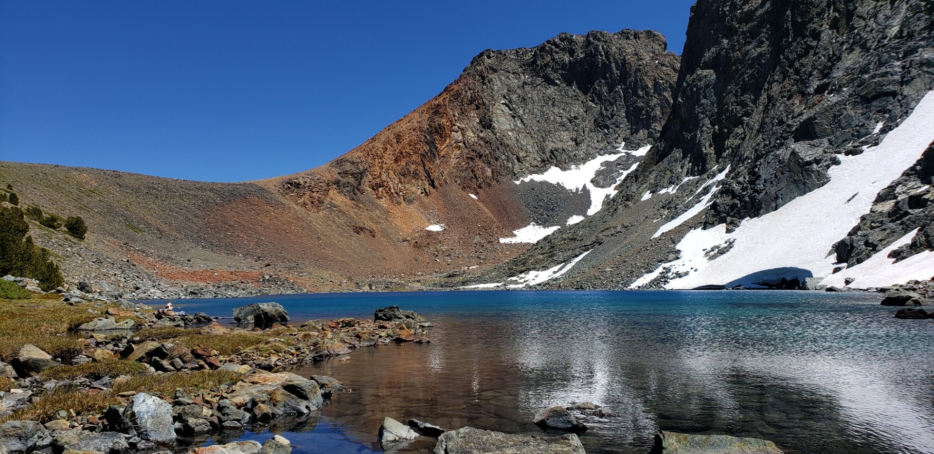
After a quick Lunch at Summit Lake it was time to head over to Parker Pass. Now the trail was only .3 miles back down the trail to head up to Parker Pass, but this seemed like a good place for a little off trail experience so I headed off behind summit lake in a trajectory that would eventually lead me to the trail maybe about a mile down-line. this route took me through another meadow region with great photo opps and then had me climb a gradual hill where i would meet up with the trail to Parker Pass. At this point in the Day it was getting Warm and the sun was beating down on me as I walked the grooved trail with now Tree cover to Parker Pass. It is a bit cruel because you can see the top for the entire last mile and frankly it seemed to never get closer for awhile. I was climbing Parker Pass for one reason today, I wanted Visit Parker Pass Lake which is located just to the South of the Pass below a Snow patch covered mountain that frankly looked volcanic but i am not a geologist. (It stood out as different)
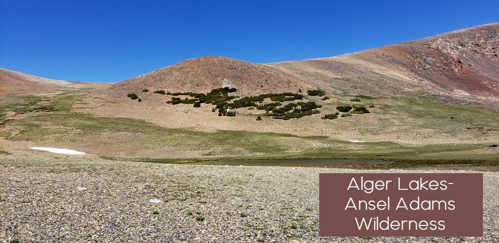
Parker Pass itself is Gateway again to a series of lakes and trail options. The Alger Lakes start just beyond the border into Ansel Adams wilderness. this area is completely baron and looks like a region left behind by the glaciers as more of a scrape heap of ground rocks that have grown a tundra like soil overtop. However this region gives backpackers another route into the Ansel Adams and John Muir wilderness traveling over Koip Pass into Devils Postpile and Gem lakes region. Based solely on perspective I would bet this alternative is for those that could not get permits over Donahue pass.

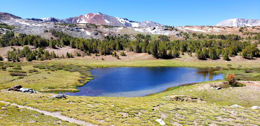
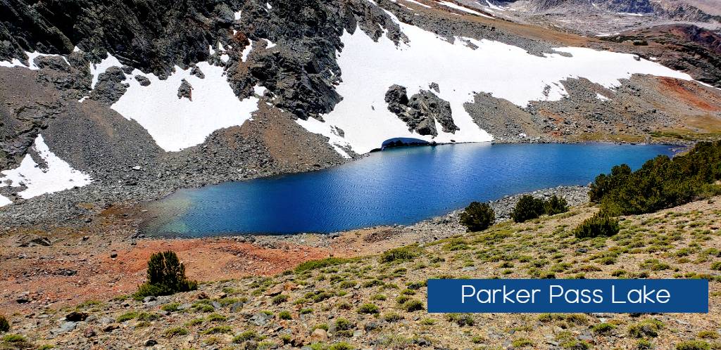
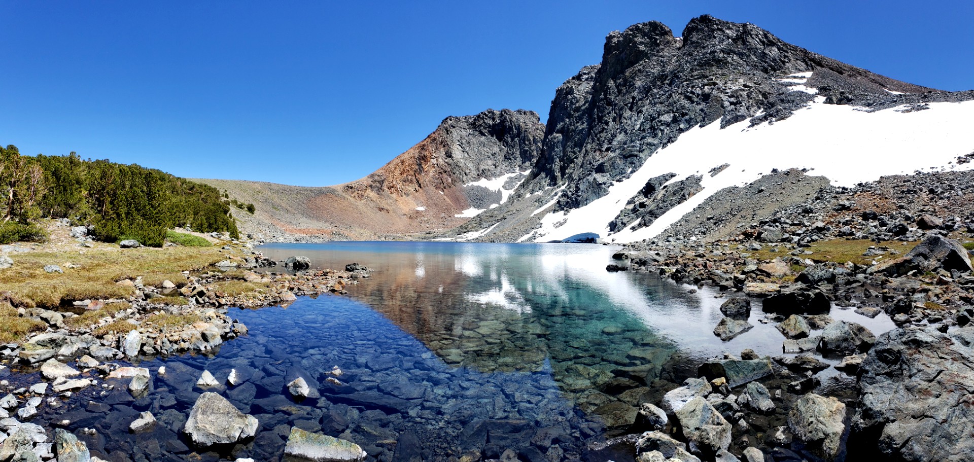
Parker Pass Lake might have been the highlight of this loop I was making. Frankly it might be the prettiest lake I have yet to see in Yosemite National Park. The glacial waters of Parks Pass Lake were so blue and clear it was breath taking to just see as I crested the slope off Park Pass. The snow hung from the banks and the water glistened as I scrambled down to the lake shores., now I have found seclusion… No camping is allowed here at Parker Pass Lake so if you are ever near this region, it is a must see in my book. I wonder how many have traveled over Parker Pass and never veered 400 feet south to peak over at the lake below?
Parker Pass Lake feeds out to the North of the lake down toward Spillway lake joining waters from Helen Lake and various tributaries in the area from mountain crevasse still filled with snow. The meadow Region from Parker Pass Lake to Spillway Lake is teaming with wildlife and up against the rising colors of the slopes around the region was spectacular vantage point.

Traveling to Spillway Lake
After departing Park Pass Lake it was time for another off trail excursion to Spillway lake. Spillway was seen from the Parker Pass Trail and is easily located if you just follow the water down hill. However with all this water also come very marshy conditions in much of this area, I found that staying a little high from the water and gradually pricking my way down the mountain of the out skirts of the meadow kept my feet dry and the travel light. Not this section I have no definitive distance, but it was further than I was expecting easily could have been 1.5 miles. My original plans were to cross the creek and scale up to Helen Lake which sits directly above Spillway lake, but my tired body and possible a little elevation sickness started to persuade me that I had done enough for the day. So I focused on a set of Water falls coming down to the shore of Spillway lake and made myself a path through he trees along the meadow edge until I reached the lake. Saw a couple dozen dear and all kinds of creatures in the meadows.
Spillway Lake
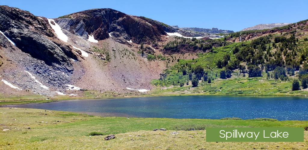
Now if I had not been to Parker Pass Lake prior to, Spillway lake would probably been the highlight lake of the trip. Waterfalls cascading down the Western edge of the lake and the green meadows that seemed to falloff to the north with views of Gaylor peaks and white mountain region in the North made this a great place to soak the feet in the water and get lost in the sounds of nature. (Note I have heard that the mosquito swarms hear are deadly, but lucky for me no mosquito problems today) I stayed here for an hour and relaxed on the lake shore knowing that I have to return someday to see Helen lake above, plus there are a series of lakes to the West (Bingham and Kuna Lakes that look inviting) . As the day was getting long it was time to head back down trail to civilization. The trail from Spillway lake follows the Creek most of the way and gives you several vantage points to enjoy. Looking back up cascading creeks to the mountains above the lake and then looking north down stream at the peaks to the north of Tioga road. Deer again were prevalent on my trip as the meadows were great place to see them laying under trees or snacking on the lush grasses. 3.8 miles back to the cars and after the first mile once again in the forest and meadows for the entire trip back.
Overview
Well as always there is no bad day hiking in Yosemite. I found this hike to be very fun and rewarding experience. The variety of lakes made it spectacular the wildlife and lush meadows with active streams were very pleasant. The elevation gain adds up quickly if you do as I did and go cross country a bit and walk between trails. Parker Pass Lake was worth the trip in itself.


